Thomaston, ME Weather Forecast
Marine Forecast: Port Clyde to Cape Elizabeth
Thomaston, Maine
Lat: 44.08N, Lon: 69.18W
Mostly Cloudy
Temp: 60°F
- Humidity:
- 36%
- Winds:
- 8 MPH WNW
- Gusts:
- 16 MPH
- Barometer:
- 30 in.
- Dewpoint:
- 33°F
- Heat index:
- 60°F
- Sunrise:
- 5:49 AM EDT
- Sunset:
- 7:21 PM EDT
- Moonrise:
- 12:01 PM EDT
- Moonset:
- 3:05 AM EDT
| Tonight...Partly cloudy this evening, then clearing. Lows in the lower 30s. Northwest winds around 10 mph with gusts up to 25 mph this evening, becoming light and variable. |
| Wednesday...Mostly sunny. Highs in the mid 50s. Northwest winds around 10 mph. |
| Wednesday Night...Mostly clear. Lows in the mid 30s. Light and variable winds. |
| Thursday...Mostly sunny. Highs in the lower 50s. Light and variable winds, becoming southeast around 10 mph in the afternoon. |
| Thursday Night...Mostly clear in the evening, then becoming partly cloudy. Lows in the mid 30s. Light and variable winds. |
| Friday...Partly sunny. Highs in the lower 50s. |
| Friday Night...A chance of showers in the evening, then rain likely after midnight. Lows in the lower 40s. Chance of rain 60 percent. |
| Saturday...Rain likely in the morning, then a chance of showers in the afternoon. Highs in the mid 50s. Chance of rain 60 percent. |
| Saturday Night...Partly cloudy with a chance of showers in the evening, then mostly clear after midnight. Lows in the upper 30s. Chance of rain 30 percent. |
| Sunday...Mostly sunny. Highs in the lower 50s. |
| Sunday Night...Partly cloudy in the evening, then clearing. Lows in the mid 30s. |
| Monday...Mostly sunny. Highs in the mid 50s. |
| Monday Night...Partly cloudy. Lows in the upper 30s. |
| Tuesday...Partly sunny. Highs in the mid 50s. |
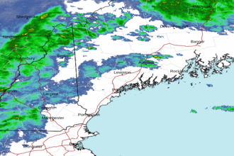 Portland ME Radar
 Northeast Radar