Alligator River Marine Forecast
| Rest Of Today...N Winds 5 To 10 Kt, Becoming E Late. Waves Light Chop. |
| Tonight...S Winds 10 To 15 Kt, Becoming Sw 15 To 20 Kt With Gusts Up To 25 Kt After Midnight. Waves A Moderate Chop, Increasing To Choppy After Midnight. |
| Wed...Sw Winds 15 To 20 Kt With Gusts Up To 25 Kt, Becoming W 10 To 15 Kt In The Afternoon. Waves Choppy, Diminishing To A Moderate Chop In The Afternoon. |
| Wed Night...W Winds Around 10 Kt, Becoming N With Gusts Up To 25 Kt After Midnight. Waves Light Chop, Increasing To A Moderate Chop After Midnight. |
| Thu...Ne Winds 15 To 20 Kt With Gusts Up To 25 Kt. Waves Choppy. |
| Thu Night...Ne Winds 10 To 15 Kt. Waves A Moderate Chop. |
| Fri...Ne Winds 10 To 15 Kt. Waves A Moderate Chop. |
| Sat...Se Winds Around 10 Kt, Becoming S After Midnight. Waves Light Chop. |
| Area Forecast Discussion National Weather Service Wakefield VA 656am EDT Tuesday April 23 2024 Synopsis High pressure centered over the local area this morning slides off the Carolina coast this evening. A weak cold front pushes through the region on Wednesday, with a few light showers possible. Strong high pressure then builds from the eastern Great Lakes eastward to off the New England coast Thursday through Friday. A marked warming trend is then expected for the upcoming weekend into early next week. Near Term - Through Tonight As of 300am EDT Tuesday... Key Messages: - Near-normal temperatures today under plentiful sunshine after a frosty start this morning. - Increasing clouds and milder tonight. The latest weather analysis reveals 1022+mb surface high pressure centered from the deep south into the Mid-Atlantic region. Low pressure was noted over SW Ontario, with a cold front extending back into the northern plains. Aloft, a pair of deep troughs are evident on early morning WV satellite imagery. The first is associated with a second deepening surface low well off the Carolina coast. The other is a weak shortwave trough diving E-SE across the Dakotas toward the upper midwest. In between, shortwave ridging over the plains to the mid-south is slowly pushing E-NE this morning. 07z Temperatures are chilly as expected, largely in the 30s to low 40s, and a the Frost Advisory in effect for much of the area away from the immediate coast still looks in good shape. For today, look for mainly sunny conditions with just a few passing high clouds as the surface high drifts off the mid-Atlantic and southeast coasts by this afternoon. The resultant SSW wind ~10mph well inland by afternoon will warm into the lower 70s well inland, with mid to upper 60s near the coast, where a cool afternoon sea-breeze is expected to stabilize temperatures, with some falling temps possible for Hampton Roads by mid to late afternoon. .SHORT TERM /WEDNESDAY THROUGH FRIDAY NIGHT/... As of 300am EDT Tuesday Key Messages: - Temperatures remain below normal through the late week period. - Scattered showers or sprinkles possible with a passing cold front Wednesday into Wednesday afternoon. - Another chance for patchy frost Thursday night into Friday morning for much of the area outside of urban Hampton Roads and coastal northeast NC. Increasing clouds move in overnight Tuesday into Wednesday morning in advance of the previously referenced front currently over the upper midwest. The increasing clouds and return flow will keep early morning lows much milder relative to this morning's readings. Forecast lows range from the mid/upper 40s over interior southern VA/NE NC, to the lower 50s elsewhere. Deterministic models remain in good agreement with the upper trough and main surface low tracking east across Ontario/Quebec into northern New England on Wednesday, dragging its cold front through the local area during the afternoon. Moist of the moisture from this system gets scoured out in the Appalachians to the west, as the low-level flow turns downslope (westerly) rather quickly. As such, only scattered light rain showers or sprinkles are anticipated. Probability of Precipitation will only be ~30%, with Quantitative Precipitation Forecast on the order of a few hundredths to a tenth of an inch at most. Timing of the front is a bit faster, and while it will be well- mixed, high temperatures have been lowered over Hampton Roads in anticipation of a bit more cloud cover during peak heating time. Highs in the low to mid 70s north, upper 60s to lower 70s along the SE coast. The front pushes SSE of the area Wednesday night, with surface high pressure building eastward across the Great Lakes. There still seems enough mixing to keep temperatures from dropping off too much except over the far N/NW zones Wednesday night. Lows will be in the upper 30s/around 40F NW to the upper 40s SE. High pressure builds east from the eastern Great Lakes to off the New England coast Thu through Fri. Mostly sunny and cool Thu/Fri with highs ranging from the upper 50s to mid 60s. Clear/mostly clear Thu night with lows ranging from the mid 30s to mid 40s. Patchy frost will be possible once again, mainly over the northern 1/2 of the FA from the piedmont to e-central VA and the eastern shore. Slightly milder as the airmass modifies (but remains near to below normal) courtesy of persistent onshore flow. Lows Friday night range through the 40s. Long Term - Saturday Through Monday As of 300am EDT Tuesday... Key Messages: - Marked warming trend expected for the weekend into early next week. - Rain chances return ahead of and with an approaching cold front Monday afternoon. The medium range forecast period begins with an amplifying upper ridge from the Gulf of Mexico to the upper midwest, expanding to the east coast over the weekend. This ridge continues to look a bit stronger than modeled earlier this week, which should keep the FA mainly dry through the weekend. Temperatures trend back upward through the period; from near normal Sat (highs in the 70s), to above normal Sun- Monday (mid 80s inland, upper 70s to low 80s coast) as the upper ridge remains across the eastern CONUS. The next system will approach Monday and Tuesday of next week, with the associated cold front approaching by the middle of next week. Some showers and storms will be possible over the NW portion of the area Monday afternoon and evening, as some pre- frontal (lee trough) convection could push into the area. More widespread showers and storms would then be possible with the frontal passage itself next Tuesday. Marine As of 320am EDT Tuesday... Key Messages: - SCAs (Small Craft Advisories) have been issued for all local waters this evening into Wednesday. - Another round of SCA (Small Craft Advisory) conditions is likely Wednesday night into Thursday behind a cold front. Low pressure remains well offshore today with high pressure sliding off the Southeast coast late this afternoon into tonight. Winds early this morning were generally W 5-10 kt. Winds diminish later this morning before becoming SE/S this afternoon, increasing to 15- 20 kt by late afternoon. As the high slides offshore, winds become S with gusts to 25 kt this evening into early tonight, becoming SW 15- 25 kt with gusts to 30 kt late tonight ahead of a cold front. Therefore, SCAs (Small Craft Advisories) are now in effect for all local waters. Winds diminish below SCA (Small Craft Advisory) criteria by Wednesday afternoon. The cold front crosses the local waters Wednesday evening into early Wednesday night with winds becoming N/NE 15-25 kt with gusts to 30 kt late Wednesday night into Thu. Another round of SCAs (Small Craft Advisories) will likely be needed for this surge. NE winds diminish Thu across the N waters but remain 15-20 kt across the S coastal waters (and potentially the lower bay/mouth of the bay). High pressure builds in across New England Thu night into Fri before gradually sliding off the coast Sat. Winds generally remain NE/E 10- 15 kt with occasional gusts to 20 kt into Sat, becoming SE late Sat and S Sat night into early next week. Waves and seas were generally 1-2 ft and 2-4 ft respectively early this morning. Waves and seas build to 3-4 ft and 4-7 ft tonight. Seas gradually subside below 5 ft by Tuesday evening before building back to 4-6 ft late Tuesday night into Thu behind the cold front. Fire Weather As of 300am EDT Tuesday Given the significant drying that occurred yesterday, fire wx could become a bit more of a concern today. Gusty SW winds of 10-12 mph with gusts to around 20 mph are expected, with afternoon relative humidities to fall into the 20 to 30 percent range over central and south central Virginia, including the Richmond metro area and the VA northern neck. With good mixing anticipated (which is notoriously not modeled well with respect to dewpoint temperatures), we will coordinate with state officials and neighboring offices later this morning to determine the need for an SPS/IFD statement. Main area of concern today would be for areas along and NNW of I-85. Tides / Coastal Flooding As of 500am EDT Tuesday... Winds become SE/S this afternoon into early tonight before becoming SW after midnight. As such, water will be pushed into the upper bay before being redirected towards the western coast of the Maryland Eastern Shore later tonight during high tide. Tidal anomalies of 1-1.6 feet are expected which should allow Bishops Head and Cambridge to reach solidly into Minor Flood stage. As such, a Coastal Flood Advisory has been issued for tonight's high tide across portions of the Maryland Eastern Shore. Winds diminish Wednesday along with tidal anomalies. NOAA Wakefield VA Office: Watches - Warnings - Advisories MD...Frost Advisory until 8am EDT this morning for MDZ021>024. Coastal Flood Advisory from midnight tonight to 8am EDT Wednesday for MDZ021>023. NC...Frost Advisory until 8am EDT this morning for NCZ012>014-030. VA...Frost Advisory until 8am EDT this morning for VAZ048-060>062- 064>069-075-076-079>083-087>090-092-093-096-097-509>522. Marine Small Craft Advisory from 4pm this afternoon to 10am EDT Wednesday for ANZ630-631. Small Craft Advisory from 4pm this afternoon to 1pm EDT Wednesday for ANZ632-634. Small Craft Advisory from 10pm this evening to 10am EDT Wednesday for ANZ633-635>637. Small Craft Advisory from 7pm this evening to 10am EDT Wednesday for ANZ638. Small Craft Advisory from 7pm this evening to 7pm EDT Wednesday for ANZ650-652-654. Small Craft Advisory from 10pm this evening to 7pm EDT Wednesday for ANZ656-658. |
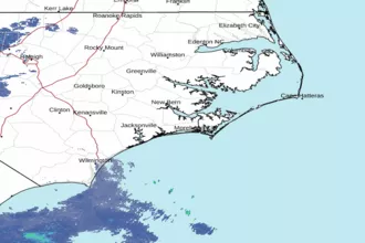 Newport NC Radar
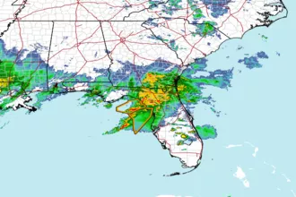 Southeast Radar
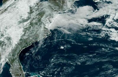 East Coast Satellite