Baffin Bay to Port Aransas Marine Forecast
| Tonight...Southeast Winds 10 To 15 Knots. Waves 2 To 3 Feet. |
| Thursday...Southeast Winds 10 To 15 Knots With Gusts Up To 20 Knots, Increasing To 20 To 25 Knots With Gusts Up To 30 Knots In The Afternoon. Waves 3 To 4 Feet, Occasionally Seas Around 5 Feet, Building To 4 To 6 Feet, Occasionally Seas Up To 8 Feet In The Afternoon. |
| Thursday Night...Southeast Winds 15 To 20 Knots With Gusts Up To 30 Knots. Waves 5 To 7 Feet, Occasionally Seas Up To 9 Feet. |
| Friday...Southeast Winds 20 To 25 Knots With Gusts Up To 30 Knots. Waves 6 To 8 Feet, Occasionally Seas Up To 10 Feet. |
| Friday Night...Southeast Winds 15 To 20 Knots With Gusts Up To 30 Knots. Waves 6 To 9 Feet, Occasionally Seas Up To 11 Feet. |
| Saturday...Southeast Winds 20 To 25 Knots With Gusts Up To 30 Knots. Waves 6 To 9 Feet, Occasionally Seas Up To 11 Feet. |
| Saturday Night...Southeast Winds 20 To 25 Knots With Gusts Up To 30 Knots. Waves 6 To 8 Feet, Occasionally Seas Up To 10 Feet. |
| Sunday...Southeast Winds 15 To 20 Knots. Waves 6 To 8 Feet, Occasionally Seas Up To 10 Feet. |
| Sunday Night...Southeast Winds 15 To 20 Knots. Waves 5 To 7 Feet, Occasionally Seas Up To 9 Feet. |
| Monday...Southeast Winds 10 To 15 Knots. Waves 4 To 6 Feet, Occasionally Seas Up To 8 Feet. |
| Monday Night...Southeast Winds 10 To 15 Knots. Waves 4 To 5 Feet, Occasionally Seas Up To 6 Feet. |
| Area Forecast Discussion National Weather Service Corpus Christi TX 143pm CDT Wednesday April 24 2024 ...New SHORT TERM, Long Term .SHORT TERM... (Tonight through Thursday night) Issued at 120pm CDT Wednesday April 24 2024 Mid/upper level ridge over South Texas this afternoon will shift to East Texas on Thursday as next trough advances into the central Rockies. This will result in the development of a surface low in the Lee of the Rockies and gradual strengthening low level flow across the southern plains into South Texas through Thursday afternoon. Given the strengthening moist southerly flow and strong low level capping inversion, expect a stratus cloud deck to redevelop over the forecast area tonight with clouds lingering most of Thursday, with the exception of the west where some clearing is expected. Winds will gust around 25-35 mph on Thursday but are not expected to reach wind advisory levels. Small Craft Advisory conditions are expected over the southern bays on Thursday expanding to the gulf waters Thursday Night. A s/w will track to the north of our forecast area Thursday night with a less than 10% chance for convection developing across the northwest brush country. Given the subsident flow aloft, continued warming will occur out west on Thursday with max temps in the mid 90s and heat indices reaching the triple digits. Elsewhere mid 80s are expected. Long Term (Friday through next Tuesday) Issued at 120pm CDT Wednesday April 24 2024 Key Messages: -Medium to high chance for Wind Advisory Conditions for portions of the Coastal Plains and Victoria Crossroads Friday and Saturday -Very warm conditions Saturday with highs around 100 degrees out west The forecast looks to remain on track from the previous issuance. A series of upper level short waves will move across the area. This will be in conjunction with above normal PWAT (Precipitable Water) values (1.7-1.9 inches). This will allow for isolated to scattered showers and thunderstorms mainly along the northern portions of the CWA (County Warning Area) and Victoria Crossroads Friday, Sunday, Monday, and Tuesday. Models (GFS/ECMWF) depict a surface low developing out west on Friday and lingering through Saturday. This will enhance the tightening of the pressure gradient over the Coastal Plains and Victoria Crossroads which will cause some periods of Wind Advisory Conditions. Conditions over the waters will be SCEC to SCA (Small Craft Advisory) in response to the elevated winds Friday through Monday. Expect hot weather through the long term with highs expected to be in the 80s and 90s each day with 100s out west Saturday. It appears that summer made an early appearance this year with all of the heat that we have been experiencing. Marine Issued at 331am CDT Wednesday April 24 2024 Weak to moderate onshore flow expected tonight. Generally moderate onshore flow will develop Thursday afternoon, as an upper level disturbance approaches the southwestern United States. Onshore flow is forecast to strengthen to moderate to strong levels Thursday night, with periods of Small Craft Advisory or Caution conditions persisting through Sunday. Winds will weaken into more moderate levels Sunday night and into weak to moderate by Monday. Isolated showers and thunderstorms will be possible daily Sunday through Tuesday as a weak disturbance moves over the area. NOAA Corpus Christi TX Office: Watches - Warnings - Advisories TX...None. GM...None. |
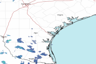 Corpus Christi TX Radar
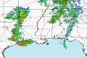 Gulf Radar