Bays and Waterways from Baffin Bay to Port Aransas Marine Forecast
| Rest Of Today...Southeast Wind 5 To 10 Knots. Bays Smooth. |
| Tonight...Southeast Wind Around 10 Knots Shifting South After Midnight. Bays Slightly Choppy To Occasionally Choppy. A Slight Chance Of Showers And Thunderstorms In The Evening. Patchy Fog In The Evening. Areas Of Fog After Midnight. |
| Wednesday...Southwest Wind 10 To 15 Knots Becoming North 15 To 20 Knots In The Afternoon. Bays Choppy To Occasionally Rough. Patchy Fog In The Morning. |
| Wednesday Night...North Wind 20 To 25 Knots. Bays Choppy To Rough. |
| Thursday...Northeast Wind 15 To 20 Knots. Bays Choppy To Occasionally Rough. |
| Thursday Night...Northeast Wind 10 To 15 Knots. Bays Slightly Choppy To Occasionally Choppy. |
| Friday...North Wind 10 To 15 Knots Shifting Southeast In The Afternoon. Bays Slightly Choppy To Occasionally Choppy. |
| Friday Night...Southeast Wind 15 To 20 Knots Becoming South 10 To 15 Knots After Midnight. Bays Choppy. |
| Saturday...South Wind 10 To 15 Knots Becoming Southeast 15 To 20 Knots In The Afternoon. Bays Choppy. |
| Saturday Night...Southeast Wind Around 20 Knots. Bays Choppy To Occasionally Rough. |
| Area Forecast Discussion National Weather Service Corpus Christi TX 116pm CDT Thu April 25 2024 Long Term (Friday night through next Wednesday) Issued at 511am CDT Thu April 25 2024 Key Messages: - Medium to high chance of Wind Advisory conditions for portions of South Texas Saturday - Very warm Saturday with highs near 100 degrees out west - Low to medium rain/storm chances daily Sunday through Wednesday A strong surface pressure gradient will develop over the area Saturday into Saturday night leading to a medium to high chance of Wind Advisory conditions. The threat will first begin over the Victoria Crossroads during the afternoon and then transition westward into the Coastal Plains and Brush Country during the early evening hours. The pressure gradient is forecast to relax by Sunday as the surface low over the Plains drifts northeastward and a surface high over the southeastern CONUS begins to build westward extending into the Gulf. Low to medium rain and thunderstorm chances (20-40%) return to the forecast on Sunday as the next mid to upper level disturbance tracks over the area combining with plentiful available moisture (PWATs (Precipitable Waters) 1.7- 1.8"). A persistent onshore flow will continue to bring moisture into the region throughout the week (PWATs (Precipitable Waters) peaking at almost 2.0" at times). This, in conjunction with the arrival of several passing disturbances aloft, will lead to additional low to medium rain and convective chances daily through mid next week. The highest precipitation chances will be across the eastern half of the CWA (County Warning Area) through Tuesday, then drift westward mid week. No flooding concerns are expected at this time. In terms of temperatures, these will be very warm on Saturday as a dryline nears the area from the west. Highs are forecast to approach the upper 90s to around 100 degrees over portions of the Brush Country and Rio Grande Plains, with maximums in the mid 80s across the east. Otherwise, expect highs to range from the low 80s to mid 90s through the end of the Extended period, with overnight lows generally in the upper 60s to mid 70s. Marine Issued at 511am CDT Thu April 25 2024 As an upper level disturbance moves across the southwestern CONUS/Plains during the period, moderate to strong onshore flow will develop over the waters. A Small Craft Advisory is in effect for the southern bays/nearshore waters this afternoon, and over the coastal waters tonight/Friday. A persistent strong onshore can be expected through Monday, with periods of Small Craft Advisory or Small Craft Exercise Caution conditions. Winds become weak to moderate during the day Monday and will persist through the remainder of the period. Isolated showers and thunderstorms will be possible daily Sunday through Tuesday as a couple weak disturbances move over the area. NOAA Corpus Christi TX Office: Watches - Warnings - Advisories TX...None. GM...Small Craft Advisory until 1am CDT Friday for GMZ231-232. Small Craft Advisory from 10am to 7pm CDT Friday for GMZ231- 232-236-237. Small Craft Advisory until 7pm CDT Friday for GMZ250. Small Craft Advisory from 10pm this evening to 7pm CDT Friday for GMZ255-270-275. |
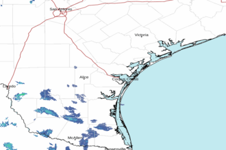 Corpus Christi TX Radar
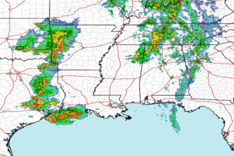 Gulf Radar