Cape Hatteras to Ocracoke Inlet, NC out 20 NM Marine Forecast
| Overnight...Sw Winds Around 20 Kt With Gusts Up To 25 Kt. Seas 4 To 5 Ft. Dominant Period 6 Seconds. A Slight Chance Of Showers And Tstms Late. |
| Thu...Sw Winds 15 To 20 Kt With Gusts Up To 25 Kt. Seas 4 To 5 Ft. Dominant Period 5 Seconds. A Slight Chance Of Showers In The Morning. |
| Thu Night...Sw Winds 10 To 15 Kt, Becoming Ne After Midnight. Seas 3 To 4 Ft. Dominant Period 7 Seconds. |
| Fri...Ne Winds 10 To 15 Kt. Seas 3 To 4 Ft. Dominant Period 8 Seconds. |
| Fri Night...Se Winds Around 10 Kt, Becoming S After Midnight. Seas 3 To 4 Ft. A Slight Chance Of Showers. A Slight Chance Of Tstms After Midnight. |
| Sat...Sw Winds 5 To 10 Kt, Becoming Nw 10 To 15 Kt In The Afternoon. Seas 3 To 5 Ft. A Chance Of Showers. |
| Sat Night...Nw Winds 10 To 15 Kt, Becoming N 15 To 20 Kt With Gusts Up To 25 Kt After Midnight. Seas 3 To 5 Ft. A Chance Of Showers And Tstms. |
| Sun...Ne Winds 15 To 20 Kt. Seas 4 To 6 Ft. A Chance Of Rain And Tstms In The Morning, Then Rain Likely. |
| Mon...Ne Winds 20 To 25 Kt, Diminishing To 15 To 20 Kt After Midnight. Seas 5 To 8 Ft. Rain Likely, Mainly In The Morning. Winds And Seas Higher In And Near Tstms. |
| Area Forecast Discussion National Weather Service Newport/Morehead City NC 815pm EDT Wednesday April 17 2024 Synopsis Shortwave and attendant cold front bringing low chances of light rain tonight. Another weak cold front cross the region by the end of the work week before another stronger cold front impacts the area next weekend. Near Term - Until 6am Thursday Morning As of 735pm Wednesday...Southerly WAA (Warm Air Advection - the movement of warm air) continues, although winds have diminished a bit at the time of this update. Radar imagery would suggest rain reaching the ground for NOBX, but dry low levels is evaporating the drops before they can reach the ground. This is supported by a lack of measurable precipitation at KMQI and K7W6. CAMs suggest highest chance of rainfall ahead of a shortwave tonight will be for areas north of hwy 264. With virga likely eating away at the stubborn dry layer for NE portions of the CWA, this region is best primed for precipitation reaching the ground. Previous Discussion...As of 1530 Wednesday...Warm front has lifted N of the FA leading to Serly WAA. Have lowered Highs a degree or two for this afternoon due to cloud coverage. Upper front and attendant shortwave will approach the region tonight. CAMs point to a broken band of precipitation crossing the FA just after midnight ahead of the s/w, but confidence is low any of this will reach the ground especially west of Highway 17 where dry air will remain stubbornly entrenched. Modestly better risk of rainfall will be along the coast where moisture profiles are less hostile. Still, the odds of precipitation are low - no higher than Chc Probability of Precipitation in any area. Persistent cloud cover and steady southwesterly winds keep temperatures elevated with overnight lows in the mid 60s. Short Term - 6am Thursday Morning Through 6pm Thursday As of 800pm Wednesday...No major changes with this update, as previous forecast is still trending well. Previous Discussion...As of 1530 Wednesday...SFC low sliding off the MidAtlantic coast will usher a weakening front through the NEern half of the FA while flow aloft becomes more downsloping NWerly in the wake of the shortwave trough axis pushing offshore. Werly background winds 10G15kt keeps seabreeze pinned along the Crystal Coast; Nern sea/sound/river breezes showing more penetration inland, aided by the front moving through at the same time. Highest Probability of Precipitation in the afternoon will be centered over the convergence zone of the Nern sound/river breezes and the front which could be enough to spark some upward motion, but the column is expected to be too dry for any meaningful rainfall. Regardless, can plan on sunny skies for most with clouds developing along the pinned Crystal Coast seabreeze and the boundaries in the N with a broader diurnal Cumulus clouds field developing inland later. Mostly sunny through the day leads to MaxTs in the upper 80s inland, low to mid 70s beaches. Long Term - Thursday Night Through Sunday As of 230pm Wednesday... A fairly active pattern is on tap this week into early next week with multiple frontal passages impacting the area. Thursday night through Friday night...Upper ridging will build back over the area late Thursday, with the axis cresting over the area early Friday with dry conditions prevailing. Another dampening mid level shortwave and attendant cold front is forecast to push across the area late Friday and Friday night, which may bring isolated to widely scattered showers and thunderstorms across the region. Most guidance keeps the best overlap of shear and instability to the west of ENC, but we'll have to monitor trends in guidance as there is a non-zero risk of some stronger afternoon storms west of HWY 17. Temps will remain above average across the Coastal Plain with highs Thursday generally in the mid to upper 80s inland and 70s along the coast. On Friday, E to NE onshore flow will bring cooler conditions along the coast, especially across the OBX where mid to upper 60s will prevail, but well inland highs expected in the mid 80s with a few upper 80s possible. Saturday through Tuesday Broad cyclonic flow prevails over the Eastern CONUS over the weekend and into early next week. A weakening cold front will drop into the area Saturday and stall just off the coast Saturday night. The timing of the front during the day Saturday will need to be monitored, as some of the 12z guidance today has come in slower with the front, which may allow more heating/destabilization to occur across southern sections of ENC. Should this slower trend hold, we'll have to watch for a strong to severe thunderstorm risk. Additional shortwave energy moving through the flow aloft will bring better forcing across the area with surface low pressure developing along the offshore front, which is forecast to pass off the OBX Sunday night and push the cold front farther offshore on Monday as high pressure builds in from the west through Tuesday. Highs Saturday will be a few degrees cooler inland with highs around 75-80 with mid 60s to mid 70s along the coast. Saturday normal inland with highs in the low to mid 80s inland and 70s along the coast. A cooler airmass builds in behind the front which, along with clouds and showers, will keep temps several degrees below normal with highs in the 60s Sunday and Monday. Temps are expected to warm back to near normal for Tuesday. Marine SHORT TERM /Tonight/... As of 1545 Wednesday...Benign boating conditions continue this afternoon as warm front lifted N through area waters earlier today. Regional observations show seas of 3-4 feet with predominantly S to SWerly 10-15kt. Several of the high-res models continue to suggest SCA (Small Craft Advisory) conditions developing offshore overnight. The less aggressive guidance still shows gusts up to 20+ kt tonight into Thursday morning. Considering how poorly the model suites resolved the winds near the front yesterday, have erred on the side of caution and went with SCAs (Small Craft Advisories) for Central and Sern coastal waters as well as PamSound overnight.Seas will remain steady at 3-4 feet through the day, building slightly to 3-5 feet with 6 ft possible over far outer waters overnight with the stronger winds. Long Term - Thursday Through Sunday As of 445am Wednesday...An active pattern will prevail in the long term with a series of mid level systems and weakening cold fronts move into the waters but conditions are expected to remain below SCA (Small Craft Advisory) criteria until late in the weekend. SW winds around 10-20 kt on Thursday will become NE behind a cold front pushing through Thursday night into Friday. Variable winds around 10 kt or less Friday night becomes Nly around 10-15 kt on Saturday as another cold front drops into the area and stalls offshore. Low pressure will develop along the front Sunday and pass off the OBX Sunday night with NE winds around 15-25 kt. Seas will generally be 2-4 ft, occasionally getting to 5 ft across the outer waters through most of the period but will build to 4-7 ft Sunday night. NOAA Newport/Morehead City NC Office - Watches - Warnings - Advisories NC...None. Marine Small Craft Advisory until 7am EDT Thursday for AMZ135(Pamlico Sound). Small Craft Advisory until 11am EDT Thursday for AMZ152(Oregon Inlet to Cape Hatteras NC)-154. Small Craft Advisory until 9am EDT Thursday for AMZ156-158. |
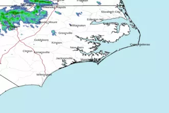 Newport NC Radar
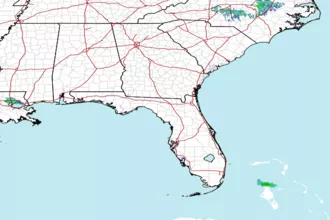 Southeast Radar
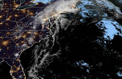 East Coast Satellite