Casco Bay Marine Forecast
| Tonight...Nw Winds 15 To 20 Kt, Increasing To 20 To 25 Kt Late This Evening, Then Diminishing To 15 To 20 Kt After Midnight, Diminishing To 10 To 15 Kt Late. Seas 2 To 4 Ft. |
| Thu...Nw Winds 5 To 10 Kt, Becoming Sw 10 To 15 Kt In The Afternoon. Gusts Up To 25 Kt. Seas 2 To 4 Ft. |
| Thu Night...Sw Winds 10 To 15 Kt With Gusts Up To 25 Kt, Becoming Nw Around 5 Kt After Midnight. Seas 2 To 3 Ft. |
| Fri...Nw Winds 5 To 10 Kt, Becoming S In The Afternoon. Seas Around 2 Ft. |
| Fri Night...Sw Winds 5 To 10 Kt. Seas Around 2 Ft. |
| Sat...Sw Winds 5 To 10 Kt, Becoming S 10 To 15 Kt With Gusts Up To 25 Kt In The Afternoon. Seas Around 2 Ft. |
| Sat Night...S Winds 10 To 15 Kt With Gusts Up To 20 Kt. Seas 2 To 3 Ft. |
| Sun...S Winds Around 10 Kt. Seas 2 To 3 Ft. |
| Sun Night...S Winds 5 To 10 Kt, Becoming W After Midnight. Seas 2 To 3 Ft. |
| Mon...Ne Winds 5 To 10 Kt, Becoming Se In The Afternoon. Seas Around 2 Ft. |
| Mon Night...Se Winds 5 To 10 Kt. Seas Around 2 Ft. |
| Area Forecast Discussion National Weather Service Gray ME 702pm EDT Wednesday April 24 2024 Synopsis Dry high pressure then moves into and across the region tonight through Saturday. A warming trend can be expected over the weekend with chance of showers Saturday night or Sunday. Warmer weather is then expected early next week for most areas except possibly the coastal plain. Near Term - Tonight 702 PMJust a few minor tweaks to T/Td/sky trends overnight with latest hires guidance coming in. Overall very little change of consequence. At this time, the cold front is slipping offshore with gusty northwest winds 25-35 and a clearing trend. over the area. Previously... A cold front will pass through the area through the evening, kicking up some winds as well as dropping temperatures overnight. After midday clearing, scattered showers have again developed over the area. This is associated with lift from the passing cold front, and should taper into the early evening. Some light snow is also expected through early evening along the US/CAD border. Mixing taps into some low level winds through late evening, creating gusts up to 35 mph. Winds should lose gust factor around midnight, with breeze continuing. Temps fall due to this cold air advection, with widespread values around freezing or off into the 20s across the mountains. Short Term - Thursday and Thursday Night Wave that enhanced winds Wednesday evening will have moved out for Thursday, with just a few gusts early. As mixing kicks in amid a very dry airmass, will likely see RH values fall into the 20s and teens through the afternoon. Limited moisture through the column should prove for a nearly full sun day. Temperatures will be cooler however, and struggle to warm outside of direct sun insolation. HRRR (High-Resolution Rapid Refresh) is depicting a seabreeze beginning early afternoon, and this should bring a wind shift to coastal communities around 2pm along with a bit more humidity as temps fall off a couple degrees. Long Term - Friday Through Wednesday We'll start off the long term period 12z on Friday with a 1030+ millibar high pressure center overhead. A cool crisp morning will give way to a sunny afternoon but with below normal temperatures. Deep layer ridging builds Friday night allowing for the fair weather to continue. Radiational cooling is likely Friday night and therefore sided with MOS guidance for lows. Deep layer ridging slowly moves eastward on Saturday but still should provide for a fair weather day with temperatures returning to the 60s. A warm front approaches from the west Saturday night with the chance of showers late. However, the ridge aloft will hold firm so capped the Probability of Precipitation some as it's entirely possible that any period of showers Saturday night and Sunday could be brief. It still should remain cloudy Sunday with low level onshore flow in place, but larger scale subsidence should keep chances of rain low. The same general setup looks to be in the cards for Monday but there is more uncertainty in temperatures as onshore flow may penetrate deeper into Maine and portions of NH. The best chance of 70+ degree readings will be over southwestern NH while lower temperatures are expected as one moves eastward. There is also a chance that some showers will spill over the ridge axis. The best chance of measurable rainfall will come Tuesday and/or Wednesday as the ridge finally breaks down and allows a trough to approach from the west. Showers and perhaps a few thunderstorms will be possible then. Marine Short Term NW winds increase this evening as a cold front crosses the waters. Some gusts to 35 kt are possible, but bulk of these winds should be 30kt or less. These winds slacken below SCA (Small Craft Advisory) criteria Thursday morning, with seas slowly lowered to 3 to 4 ft through the day. A seabreeze may form during the afternoon, turning winds onshore for the bays/harbors. Long Term Winds and seas to remain below thresholds hazardous to small crafts as high pressure builds over the waters Fri-Mon. NOAA Gray/Portland ME Office - Watches - Warnings - Advisories ME...None. NH...None. Marine Small Craft Advisory until 8am EDT Thursday for ANZ150-152- 154. Small Craft Advisory until 4am EDT Thursday for ANZ151-153. |
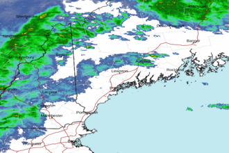 Portland ME Radar
 Northeast Radar