Little Egg Inlet to Great Egg Inlet NJ out 20 NM Marine Forecast
| Overnight...S Winds 15 To 20 Kt With Gusts Up To 25 Kt. Seas 3 To 4 Ft, Building To 4 To 6 Ft. Wave Detail: S 3 Ft At 4 Seconds And E 3 Ft At 9 Seconds, Becoming S 4 Ft At 4 Seconds And E 4 Ft At 10 Seconds. |
| Wed...Sw Winds 10 To 15 Kt With Gusts Up To 25 Kt. Seas 5 To 7 Ft. Wave Detail: S 4 Ft At 5 Seconds And E 4 Ft At 11 Seconds. A Chance Of Showers In The Morning. |
| Wed Night...Nw Winds 10 To 15 Kt, Becoming Ne 15 To 20 Kt After Midnight. Seas 4 To 5 Ft. Wave Detail: Ne 5 Ft At 10 Seconds And S 3 Ft At 6 Seconds. |
| Thu...Ne Winds 15 To 20 Kt, Diminishing To 10 To 15 Kt In The Afternoon. Seas 4 To 5 Ft. Wave Detail: Ne 5 Ft At 6 Seconds And S 2 Ft At 6 Seconds. |
| Thu Night...E Winds 5 To 10 Kt. Seas 2 To 4 Ft. Wave Detail: Se 4 Ft At 7 Seconds. |
| Fri...E Winds 5 To 10 Kt. Seas 2 To 3 Ft. Wave Detail: E 3 Ft At 8 Seconds. |
| Fri Night...Se Winds Around 10 Kt. Seas 2 To 3 Ft. |
| Sat...Se Winds 10 To 15 Kt. Seas 2 To 3 Ft. |
| Sat Night...S Winds 10 To 15 Kt. Seas Around 3 Ft. |
| Sun...S Winds 10 To 15 Kt. Seas 3 To 4 Ft. |
| Sun Night...Sw Winds 10 To 15 Kt. Seas 3 To 4 Ft. |
| Area Forecast Discussion National Weather Service Mount Holly NJ 1023pm EDT Tuesday April 23 2024 Synopsis The center of high pressure will continue to build to our south as low pressure tracks through Ontario and Quebec. This will drag a cold front will across our region Wednesday. High pressure then arrives from the Great Lakes Thursday before shifting to our northeast and east during Friday. A warm front should lift north of our area late Saturday, then a cold front gradually approaches later Monday. Near Term - Through Wednesday High clouds are increasing, but temperatures have fallen fairly rapidly into the 50s this evening due to both the lack of clouds and dew points in the low to mid 30s. However, with the approach of an upper- level trough, clouds and dew points will both increase through the overnight hours which will slow the rate of cooling. Overnight lows will be in the upper 40s to low 50s. With the approaching trough, some showers may move into the region, particularly during the pre- dawn hours Wednesday morning. However, with the drier air in place, these showers are expected to remain isolated to scattered so Probability of Precipitation remain around 20-30%. The upper-level trough is then forecast to swing across our region during the day Wednesday. This will drive a cold front across our area during mainly Wednesday morning, bringing a break to the showers, particularly across the southern half of the area. This system looks to have limited moisture with it, without a tap to Gulf of Mexico moisture, and therefore rainfall amounts are forecast to be very light. While the main cold front shifts offshore by early afternoon, a secondary cold front or trough (dew point front) may arrive by late afternoon. Since the cold front continues to look faster, more drying is forecast to be working into the area through the afternoon. This would tend to decrease the instability, however the model forecast soundings show some weak instability present in the afternoon. The overall forcing though may be on the weaker side, however the model forecast soundings also show lowering freezing levels and steepening low level lapse rates. If a heavy shower or thunderstorm were able to develop in the afternoon ahead of the dew point front, then locally gusty winds and small hail will be possible. Overall though with the extent of the drying forecast from about late morning through the afternoon, the thunder potential looks to be on the low side. Probability of Precipitation for this period are around 15-25%. Mild temperatures Wednesday for most of the area with highs in the upper 60s to low 70s. However, a strengthening/gusty west to northwest wind will be in place in the afternoon and evening with gusts of 25-30 mph possible. The sky will clear especially later in the day as high pressure begins to build in. Short Term - Wednesday Night Through Friday Colder, drier air moves in Wednesday night due to northerly winds in the wake of the cold front. It looks like the winds may stay up enough to keep frost from being an issue but it does look like portions of NW NJ and the southern Poconos will see lows get down to right around or below freezing so a Freeze Watch has been issued for our NW NJ zones where the growing season has started. A notably colder and dry air mass will be in place Thursday despite a mainly sunny sky with high temperatures mostly in the 50s. An onshore wind will also keep it even cooler along the coastal areas. Thursday night may feature more areas of frost with temperatures dropping into the 30s for much of the area and lighter winds compared to Wednesday night. This will be followed by another mainly sunny day for Friday under the continuing influence of high pressure that will be starting to shift offshore. This will help cause winds to shift from ENE early in the day to ESE and then eventually SSE. High temperatures should be about 5 degrees warmer compared to Thursday with highs mostly in the low to mid 60s except 50s near the coast and over the southern Poconos. Long Term - Friday Night Through Tuesday Surface high pressure will be over the western Atlantic Friday night through Saturday as an upper level ridge starts to build along the east coast. Meanwhile low pressure tracks north and east into the upper Great Lakes helping pushing a warm front through PA and upstate NY. This will bring the area a mainly cloudy day but the chance of showers looks low...only around 15 to 20 percent near the I-95 corridor and 20 to 30 percent over the Lehigh Valley into the southern Poconos. Highs should be mainly in the upper 50s to low 60s. For Saturday night through Sunday, the initial low tracks by well to to our north over eastern Canada but by later Sunday a new low will be emerging over the central CONUS. This will help keep the upper level ridge in place over the east with a southwest flow at the surface ushering in warmer air. As a result, expect highs shooting into the mid to upper 70s for most under variable cloud cover. Right near the coast and over the Pocono Plateau it will be cooler though with highs mainly in the upper 60s to low 70s. By early next week, temperatures have the potential to be even warmer than Sunday as they may get into the low to mid 80s. However there will also be an approaching cold front that will bring chances for some showers and storms beginning as early as late Monday with better chances for these by Tuesday afternoon into the early evening. Marine Latest observations and guidance point towards winds staying elevated across the Delaware Bay through the overnight period. With the approach of the frontal boundary, expecting the pressure gradient to tighten and allow for winds to remain in Small Craft Advisory criteria as a result. Winds and seas also picking up a bit earlier across the southern waters, so moved up the Small Craft Advisory onset time to begin this evening. Winds across the Delaware Bay will subside around daybreak. Winds diminish across the coastal waters through the morning, but remain gusty around 20 kts during the afternoon. Seas will continue to build, however, peaking around 5-7 feet Wednesday afternoon. Outlook... Wednesday night through Thursday...Small Craft Advisory conditions Wednesday night with these diminishing Thursday morning. Friday through Sunday The conditions are anticipated to be below Small Craft Advisory criteria. Tides / Coastal Flooding A period of southerly flow will occur into Wednesday morning ahead of a cold front. This is forecast to result in surge values rising to 1-2 feet above normal along Delaware Bay, the tidal Delaware River, and Chesapeake Bay. With the full moon occurring today, astronomical tides will be maximized around this time as well. This should result in some areas of minor coastal flooding with the Wednesday morning high tide. As it stands currently (Tuesday afternoon), sites in the Delaware Bay and the Chesapeake will touch minor flooding, but stay below the threshold to issue an Advisory. PETSS guidance remains relatively bullish on Tolchester Beach getting near Moderate, with some guidance suggesting they will not even touch minor at all. If anywhere were to need an advisory, it would be the Maryland Eastern Shore, but the forecast suggests that isn't necessary at the moment. Coastal flooding is not currently anticipated along the Atlantic coast, except for potentially Barnegat Bay. NOAA Mount Holly NJ Office: Watches - Warnings - Advisories PA...None. NJ...Freeze Watch from late Wednesday night through Thursday morning for NJZ001-007-008. DE...None. MD...None. Marine Small Craft Advisory until 7am EDT Wednesday for ANZ430-431. Small Craft Advisory until 6am EDT Thursday for ANZ450>455. |
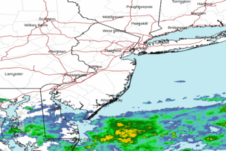 Mount Holly NJ Radar
 Northeast Radar
 East Coast Satellite