Port Aransas to Matagorda Ship Channel 20 - 60 NM Marine Forecast
| Rest Of Today...Southeast Winds 10 To 15 Knots. Waves Around 3 Feet. |
| Tonight...Southeast Winds 10 To 15 Knots. Waves 3 To 4 Feet, Occasionally Seas Around 5 Feet. |
| Wednesday...Southeast Winds Around 10 Knots. Waves Around 3 Feet. |
| Wednesday Night...Southeast Winds 10 To 15 Knots With Gusts Up To 20 Knots. Waves 3 To 4 Feet, Occasionally Seas Around 5 Feet. |
| Thursday...Southeast Winds 10 To 15 Knots, Increasing To 15 To 20 Knots In The Afternoon. Waves 3 To 5 Feet, Occasionally Seas Up To 6 Feet. |
| Thursday Night...Southeast Winds 20 To 25 Knots With Gusts Up To 35 Knots. Waves 5 To 7 Feet, Occasionally Seas Up To 9 Feet. |
| Friday...Southeast Winds 20 To 25 Knots, Diminishing To 15 To 20 Knots In The Afternoon. Waves 6 To 7 Feet, Occasionally Seas Up To 9 Feet. |
| Friday Night...Southeast Winds 15 To 20 Knots. Waves 6 To 7 Feet, Occasionally Seas Up To 9 Feet. |
| Saturday...Southeast Winds Around 20 Knots. Waves 7 To 8 Feet, Occasionally Seas Up To 10 Feet. |
| Saturday Night...Southeast Winds Around 20 Knots. Waves 7 To 8 Feet, Occasionally Seas Up To 10 Feet. |
| Area Forecast Discussion National Weather Service Corpus Christi TX 643am CDT Tuesday April 23 2024 Long Term (Wednesday night through next Monday) Issued at 246am CDT Tuesday April 23 2024 Key Messages: ▶ Minor to moderate risk of heat-related impacts Saturday as feels- like temperatures flirt around 100 An upper-level ridge will continue building into the region Wednesday and Thursday. By Thursday night, a series of mid-level troughs will dig into the Four Corners region and traverse across the Great Plains. This will eject several shortwaves across the region late this week into this weekend. Despite the presence of the shortwaves and elevated PWAT (Precipitable Water) values, the lack of available lift across the region with a strong cap will keep rain chances low below 20%. The biggest story within the long term will be the warm temperatures. Daytime highs late this work week will range from the mid 80s near the coast to the mid 90s across the Brush Country. By this weekend, daytime highs will flirt with the 100 degree mark across the Brush Country while coastal areas climb into the mid to upper 80s. When you combine the moisture across the region with the warm temperatures, heat index values are expected to climb into the upper 90s near the coast with areas within the Brush Country and Coastal Plains have a low to medium chance of going over 100 degrees. Overnight lows this week and into this weekend will remain mild with lows ranging from the low to mid 70s. Marine Issued at 246am CDT Tuesday April 23 2024 Weak to moderate onshore flow over the coastal waters today through Wednesday. Weak to moderate southeast flow Thursday is expected to strengthen to over 20 knots Thursday and continue impacting our local waters through Saturday. Winds are expected to weaken back to more moderate levels Sunday into early next week. With strong winds most of the week, there is a high chance for Small Craft Advisory conditions. NOAA Corpus Christi TX Office: Watches - Warnings - Advisories TX...None. GM...None. |
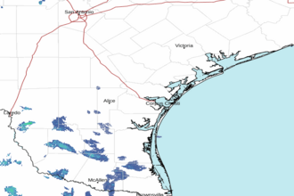 Corpus Christi TX Radar
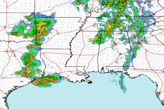 Gulf Radar