Vineyard Sound Marine Forecast
| Tonight...Ne Winds 10 To 15 Kt. Gusts Up To 20 Kt This Evening. Seas 2 To 3 Ft. Wave Detail: E 2 Ft At 3 Seconds And Se 2 Ft At 6 Seconds. A Chance Of Showers This Evening. A Slight Chance Of Showers After Midnight. |
| Fri...E Winds Around 10 Kt. Seas 2 To 3 Ft. Wave Detail: Se 2 Ft At 7 Seconds And E 1 Ft At 2 Seconds. |
| Fri Night...S Winds 5 To 10 Kt. Seas Around 2 Ft. Wave Detail: S 2 Ft At 6 Seconds And S 1 Ft At 3 Seconds. Patchy Fog After Midnight. Showers Likely After Midnight With Vsby 1 To 3 Nm. |
| Sat...Sw Winds 5 To 10 Kt. Seas Around 2 Ft In The Morning, Then 1 Foot Or Less. Wave Detail: Se 2 Ft At 6 Seconds And Sw 1 Ft At 3 Seconds, Becoming Sw 1 Ft At 4 Seconds And Se 1 Ft At 6 Seconds. Showers Likely, Mainly In The Morning. Patchy Fog In The Morning With Vsby 1 To 3 Nm. |
| Sat Night...W Winds 10 To 15 Kt With Gusts Up To 20 Kt. Seas Around 2 Ft. Wave Detail: W 2 Ft At 4 Seconds And S 2 Ft At 7 Seconds. |
| Sun And Sun Night...W Winds 15 To 20 Kt With Gusts Up To 25 Kt. Seas 2 To 4 Ft. Wave Detail: W 2 Ft At 4 Seconds And S 1 Ft At 7 Seconds. |
| Mon Through Tue...S Winds 10 To 15 Kt With Gusts Up To 20 Kt. Seas 1 Foot Or Less. |
| Tue Night...S Winds 10 To 15 Kt With Gusts Up To 25 Kt. Seas 2 To 4 Ft. A Chance Of Showers. Seas Are Reported As Significant Wave Height, Which Is The Average Of The Highest Third Of The Waves. Individual Wave Heights May Be More Than Twice The Significant Wave Height. |
| Area Forecast Discussion National Weather Service Boston/Norton MA 727pm EDT Thu April 18 2024 Synopsis Cool with a few showers into the evening. A more seasonable day on Friday, along with dry conditions during the daytime hours. A cold front brings another round of showers overnight into early Saturday morning. Dry for the rest of Saturday and all day Sunday with breezy conditions both days. The dry stretch of weather continues as we head into early next week, with the next chance for unsettled weather being Wednesday. Near Term - Until 6am Friday Morning 715 pm area of light rain is across RI and eastern MA and trying to move east, but it is running into a wall of very dry air. Expect the precipitation to dissipate within the next 2-3 hours. Noted that the latest hi-res models are all too quick with dissipation, so updated hourly Probability of Precipitation more on radar extrapolation, but it doesn't substantially change the forecast. 345 pm Highlights: * Raw afternoon with areas of light rain, turning drier overnight, but can not rule out a spot shower across eastern Massachusetts and Rhode Island. Southern New England stuck under a blanket of thick clouds while just to the north, people of Maine are enjoying lots of sunshine. A shortwave passing through continues to produce areas of light rain. Most of the day has been largely dry, thanks to drier air to the northeast. This light rain continues to move east this afternoon, ending early this evening. Overall a cool and raw rest of the afternoon for southern New England with temperatures in the 40s. Overnight, southern New England is between surface high pressure to the north over Nova Scotia and low pressure to the south over the outer waters. This set up will allows for on shore flow tonight. A few showers are possible, though do think much of tonight remains dry. A mid-level shortwave drops down out of northern New England and will help in producing scattered light rain mainly over the eastern half of the CWA. Though, with this afternoon, the high pressure to the north does provide a fair amount of dry air and that will limit the coverage. This is a slight change from the previous forecast, did add slight chance POPs for the overnight period for parts of eastern Massachusetts and Rhode Island. East/northeast winds, strongest at the south coast with gusts to 20 MPH, while further north winds are fairly light and at times variable in direction. Night time lows are seasonable, upper 30s across the interior and low 40s by the coast. Short Term - 6am Friday Morning Through Friday Night 345 pm Highlights: * Slight improvement for Friday with drier weather for the daylight hours and near seasonable temperatures. * Unsettled overnight with another chance for light rain, especially along the south coast near daybreak on Saturday. Some improvement weatherwise on Friday with surface high pressure expanding into southern New England, along with mid-level ridging. A warmer, more seasonable day with highs in the upper 50s and low 60s are on tap. Where temperatures may struggle are along the immediate coast as the winds are still coming off of the water. Areas of low clouds to start gives way to breaks of sunshine late morning into early afternoon, short-lived as mid and high clouds move in from west to east ahead of a cold front. Winds are more or less out of the southeast due to the flow from the surface high based in eastern Quebec and surface low well off to the south near Bermuda. The pressure gradient eases allowing for gusts less than 20 MPH at the coast. Increasing clouds from west to east during the second-half of the day ahead of an approaching front. A prefrontal trough could set off a few showers across western Massachusetts and northern Connecticut late afternoon, but do think the bulk of any perception will come with the frontal passage overnight, then kick off shore shortly after sunrise on Saturday. That said, do not anticipate a soaking rain, much of southern New England receives a few hundredths of an inch, and the immediate south coast, Cape, and Island receive around a quarter to a third of an inch. Wind shifts overnight from southeast to southwest, no strong gusts are expected. Overnight lows dip into the middle 40s. Long Term - Saturday Through Thursday 345 pm Key Point: * Fire weather concerns this weekend through Tuesday Fairly high consistency amongst the 12z global guidance runs as well with prior runs. So that results in overall higher than average confidence. In general, most of us will consider the weather for most of the period to be pretty nice. A weak front will be moving offshore during the first part of Saturday, only bringing a few light showers. Behind the front, a much drier airmass will be spreading in. So that will result in clearing skies. Have again blended in the warmer side of guidance for temperatures and lower side of guidance for dewpoints. Forecast soundings still show excellent mixing (5000-6000ft) developing in the afternoon along with westerly winds. Being still a "pre- greenup" phase of vegetation, that usually means temperatures overachieve and humidity levels go lower than most guidance thanks to the combo of downsloping and deep boundary layer mixing. We should see widespread mid 60s for highs, perhaps making a run at 70F in the CT River Valley. Sunday will be similar, though with 850mb temperatures slightly cooler (down around -1C vs +1C on Saturday), daytime highs will be a few degrees cooler, primarily either side of 60F. Again deep boundary layer mixing (6000-7000ft) will act to bring down some of the 25kt winds aloft along with dry air. Thus winds will be gustier than on Saturday and lower dewpoints. The combo will mean we will be flirting with some of the fire weather thresholds (RH <30%, Frequent gusts >25mph, less than 1/4" of rain in 3 days). Monday, high pressure will move overhead and maintain the dry weather. Still a dry airmass and deep mixing, but winds will be weaker, so will still need to monitor fire weather aspects, but don't think it's as significant a concern. Tuesday will still be dry, but with high pressure moving off the east coast, winds will start to turn southerly. Guidance showing another weak front coming through Wednesday, so stuck with NBM PoPs. Rainfall amounts again will be light. Dry weather should return for Thursday. Marine Forecaster Confidence Levels: Low - less than 30 percent. Medium - 30 to 60 percent. High - greater than 60 percent. 345pm Tonight and Friday...High confidence. Pressure gradient weakens as the wave of low pressure continues to move further southeast and away from the region. Seas will also diminish, but some 5 foot seas to linger across our southern outer- waters, extending small craft headlines in those locations through Friday late afternoon. Winds on Friday remain out of the east and less than 20 knots. Friday Night...High confidence. Wind direction from southeast to southwest with the passage of a frontal boundary, along with rain chances. Areas of fog is possible with reduced visibilities. Seas remain below 4 foot. Outlook /Saturday through Tuesday/... Saturday: Winds less than 25 kt. Chance of rain showers. Local visibility 1 to 3 nm. Saturday Night: Winds less than 25 kt. Seas locally approaching 5 ft. Sunday through Tuesday: Winds less than 25 kt. NOAA Boston MA Office: Watches - Warnings - Advisories CT...None. MA...None. RI...None. Marine Small Craft Advisory until 7pm EDT Friday for ANZ255-256. |
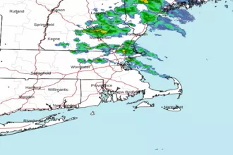 Boston MA Radar
 Northeast Radar
 East Coast Satellite