Cape Lookout to Florence OR between 150 and 250 NM Offshore Forecast
| Tonight...Nw Winds 15 To 25 Kt. Seas 10 To 14 Ft. |
| Thu...Nw Winds 10 To 20 Kt, Becoming N To Nw 5 To 15 Kt. Seas 7 To 11 Ft. |
| Thu Night...Nw Winds 5 To 10 Kt, Becoming Variable. Seas 5 To 8 Ft. |
| Fri...Variable Winds Less Than 5 Kt, Becoming S To Se 5 To 15 Kt. Seas 4 To 6 Ft. |
| Fri Night...S Winds 15 To 25 Kt. Seas 4 To 7 Ft. |
| Sat...S To Sw Winds 10 To 20 Kt. Seas 4 To 8 Ft. |
| Sat Night...S To Sw Winds 5 To 15 Kt, Becoming W. Seas 5 To 6 Ft. |
| Sun...W To Sw Winds 5 To 15 Kt, Becoming S. Seas 8 To 14 Ft. |
| Sun Night...E To Se Winds 5 To 15 Kt, Becoming E To Ne 5 To 10 Kt. Seas 9 To 13 Ft. |
| Mon...N Winds 10 To 15 Kt. Seas 7 To 9 Ft. |
| Mon Night...N To Nw Winds 5 To 15 Kt. Seas 6 To 8 Ft. |
| Area Forecast Discussion National Weather Service Portland OR 1052pm PDT Wednesday April 15 2026 Updated aviation discussion and hazards. Synopsis Post-frontal rain and mountain snow showers continue but will decrease coverage through Thursday night. Any heavier shower may produce small hail, while there is also a 15-30% chance of isolated thunderstorms this afternoon and evening. Accumulating snow continues above 2500 feet and Winter Storm Warnings remain in effect in the Cascades through tonight. The cooler airmass will also favor frost/freeze conditions tonight and possibly Thursday night. .SHORT TERM...Now through Friday Night...The potent cold front which crossed the region last night through this morning has exited the region to the south and east. Behind the front, scattered to numerous rain and mountain snow showers will linger into Thursday as a closed upper-level low passes overhead. With the cold core low aloft, any surface heating during sun breaks between showers will easily destabilize the column, generating perhaps 200-500 J/kg of SBCAPE. When combined with low freezing levels around 2500 ft, even a heavy shower could result in small hail reaching the surface. There is additionally a 15-30% chance of isolated thunderstorms this afternoon and evening, although limited instability will cap overall thunderstorm intensity. These chances will decrease after sunset, but may linger later into the evening as the coldest air within the upper low shifts overhead. Meanwhile in the Cascades above 2500 ft, snow showers will continue to produce accumulating snowfall. Winter Storm Warnings remain in effect until 5am Thursday as another 9-12 inches of snow may fall, resulting in storm total accumulations of 1-2 feet at and above pass level. As the upper low exits eastward and heigheights begin to rise aloft, rain showers will tend to dwindle in coverage tonight through Thursday and the cooler air mass will see temperatures fall to near-freezing across portions of the region. Despite morning low temperatures of 32-36 degrees across the lower elevations of NW Oregon and SW Washington, the combination of partly cloudy skies and persistent light winds tonight may inhibit widespread frost formation. Frost Advisories nonetheless remain in effect from 1-9am Thursday west of the Cascades with the exception of the immediate coast, Portland/Vancouver metro, and Columbia Gorge where temperatures will remain relatively warmer. East of the Cascade crest in the Upper Hood River Valley, temperatures will more likely fall into the upper 20s to low 30s, and a Freeze Warning has therefore been issued for 1-9am Thursday. Agricultural interests and those with sensitive outdoor plants should plan to take protective action to prevent plant damage. Conditions will be even more supportive of radiational cooling on Thursday night, however the slowly moderating air mass may counteract that tendency. A Freeze Watch has been issued from 1-9am Friday for the areas most likely to see temperatures fall below freezing, namely the Upper Hood River Valley and the Cascade foothills of Marion, Linn, and Lane Counties. As upper-level ridging builds on Friday, drier and warmer weather is expected across the region, although there remains some uncertainty in the progression of yet another upper low over the Northeast Pacific. This low or open trough may move nearer to the region and bring clouds and rain, although confidence is relatively low and rainfall chances only reach 5-10% by late Friday night. -36 Long Term Saturday through Wednesday An upper-level low or open trough tracking from the Gulf of Alaska over the Northeast Pacific will be the driver of sensible weather this weekend and into early next week, and the forecast remains sensitive to its low-confidence evolution. An upper low located nearby will favor cloudy skies and rainfall chances, while a position well to the west would see continued warm and dry weather. If it is located off the northern CA or southern OR coast, the pattern could allow sufficient moisture to move northward on its eastern flank to support convection along the Cascades. -36 Marine Post frontal showers will increase probability for lightning over the waters through around 1700 today. Small Craft Seas persist due to a westerly swell combined with a westerly wind wave. These small craft seas are hovering right around 9-10 ft at 8 seconds. Have extended the advisory through Thursday morning, though will see a steady decline in seas shifting from west to east. In addition, there will be a strong ebb early Thursday morning for the Columbia River Bar. The inner waters will see lowering seas as early as early Thursday morning. Winds will remain westerly through Friday morning, then shift to the north as a high pressure ridge sets up over the waters. This summer time pattern will bring increased winds to PZZ253 in the afternoon. While not quite a low- level jet, we could see a short burst of gusts up to 25 kt. High pressure over the area will maintain more settled conditions through early next week. -27 NOAA Portland OR Office: Watches - Warnings - Advisories OR...Frost Advisory until 9am PDT Thursday for ORZ104>110-114>118. Freeze Warning until 9am PDT Thursday for ORZ121-123>125. Freeze Watch from late Thursday night through Friday morning for ORZ121-124-125. Winter Storm Warning until 5am PDT Thursday for ORZ126>128. WA...Frost Advisory until 9am PDT Thursday for WAZ203>205-208. Winter Storm Warning until 5am PDT Thursday for WAZ211. PZ...Small Craft Advisory until 8am PDT Thursday for PZZ210. Small Craft Advisory until 5pm PDT Thursday for PZZ251>253- 271>273. |
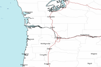 Portland OR Radar
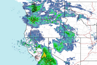 Northwest Radar