Juan de Fuca Strait - BC Waters - West Entrance Marine Forecast
| Winds... Wind South 10 To 20 Knots Tonight And Monday. |
| Waves... .Tonight... Waves 2 Ft Or Less. |
| Waves... .Mon... Waves 2 Ft Or Less. |
| Waves... .Mon Night... Waves 2 Ft Or Less. |
| Waves... .Tue... Waves 2 Ft Or Less. |
| Waves... .Tue Night... . |
| Skies... Tonight, Periods Of Rain. Monday, Cloudy. 30 Percent Chance Of Showers In The Morning. |
| Tuesday...Wind Light Increasing To West 10 To 20 Knots In The Afternoon. |
| Wednesday...Wind West 5 To 15 Knots Becoming West 10 To 20 Late In The Day. |
| Thursday...Wind West 5 To 15 Knots Becoming West 10 To 20 Late In The Day. |
Marine Weather Statement For The Pacific Waters
Issued By Environment Canada 3:57pm PDT Sunday 26 July 2026.
A 1002 Mb Low Will Approach Northern Explorer Monday Morning. Ahead Of The Low, Southerly Gales Will Develop Over Explorer, North Vancouver Island, And The Central Waters Monday Afternoon.
Technical Marine Synopsis For The Pacific Waters
Issued By Environment Canada 4:00pm PDT Sunday 26 July 2026 For Tonight And Monday. The Next Scheduled Synopsis Will Be Issued At 9:30pm PDT.
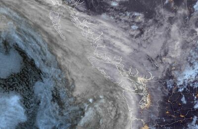
Systems Position. At 4:00pm PDT Today Weakening Frontal System Located On A Line North-South Over Southern Vancouver Island.
At 4:00pm PDT Today Low 1004 Mb Located West Of Explorer. By 4:00pm PDT Monday Low 1002 Mb Located Over Northern Explorer.
 Pacific Satellite