Marine Weather Net

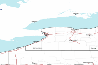
Lake Erie - Ripley to Dunkirk NY Marine Forecast


TODAY

NW
WINDS
5 - 15
KNOTS

TONIGHT

NE
WINDS
10
KNOTS

SUNDAY

NE
WINDS
10 - 15
KNOTS

SUNDAY NIGHT

N
WINDS
15 - 25
KNOTS

The Marine Weather Forecast In Detail:
LEZ040 Forecast Issued: 616 AM EST Sat Nov 08 2025

Today...Northwest Winds 5 To 15 Knots Becoming North Less Than 10 Knots. A Chance Of Showers Early And Again Late. Waves 2 To 4 Feet Subsiding To 1 Foot Or Less.
Tonight...Northeast Winds 10 Knots Or Less Increasing To 10 To 15 Knots. Rain. Waves 2 Feet Or Less.
Sunday...Northeast Winds 10 To 15 Knots Increasing To 15 To 25 Knots. Rain. Waves 2 Feet Or Less Building To 4 To 7 Feet. Waves Occasionally Around 9 Feet.
Sunday Night...North Winds 15 To 25 Knots. Rain And Snow. Waves 4 To 7 Feet Subsiding To 2 To 4 Feet. Waves Occasionally Around 9 Feet.
Monday...Northwest Winds 10 To 15 Knots Becoming West And Increasing To 15 To 25 Knots. Snow Showers. Waves 2 To 4 Feet Building To 4 To 7 Feet. Waves Occasionally Around 9 Feet.
Tuesday...West Winds To 30 Knots Becoming Southwest And Increasing To 35 Knot Gales. Snow And Rain Showers. Waves 7 To 10 Feet Building To 8 To 12 Feet. Waves Occasionally Around 15 Feet.
Wednesday...West Gales To 40 Knots Diminishing To 30 Knots. Rain Showers. Waves 9 To 13 Feet Subsiding To 8 To 11 Feet. Waves Occasionally Around 16 Feet.
SHARE THIS PAGE:           
Area Forecast Discussion
National Weather Service Buffalo NY
950am EST Sat Nov 8 2025

Synopsis
High pressure will briefly build across the area today, and will provide us with a cooler and mainly dry day...with the possible exception of a few spotty showers east of the lakes. Much more unsettled weather will then make a quick return tonight and Sunday as another area of low pressure crosses the area...with mainly rain south of Lake Ontario and a possible wintry mix across the North Country eventually giving way to snow Sunday afternoon and night as much colder air wraps in behind the departing low. The much colder airmass will also eventually bring a period of accumulating lake snows southeast and east of the lakes Monday night and Tuesday.

Near Term - Through Tonight
Weak high pressure will build across our region from west to east today...while the next area of low pressure will begin to slowly organize across the mid-Mississippi Valley. As this occurs... tonight's cold front will become increasingly west-east oriented while stalling out to our south. A few more spotty light upslope and lake-driven showers will remain possible east of the lakes into the first part of this morning...with additional scattered showers then becoming possible across the Southern Tier again later in the day as increasing amounts of moisture begin to advect eastward along the stalled out-boundary to our south. Otherwise the day should be dry and seasonably cool...with highs mostly between 45 and 50.

As we move into tonight...the aforementioned surface low will gradually deepen and become better organized as it makes its way to the Upper Ohio Valley. Increasing isentropic upglide/warm advection aloft out ahead of this feature will lead to increasingly widespread precipitation working back across the area from southwest to northeast. With respect to ptype...this will be a function of warmer air overspreading our region above an underlying layer of colder easterly to to northeasterly flow. Thermal profiles currently suggest that the bulk of this should be rain south of Lake Ontario...with perhaps a little snow mixing in across Niagara and Orleans counties given slightly colder near-surface temperatures there. Meanwhile across the North Country...thermal profiles will be much colder and supportive of mainly snow at the onset...before warming aloft potentially allows for some sleet and/or rain to begin mixing in late in the night across the Tug Hill and southern Lewis county. As for low temps...these should range from the mid/upper 20s across the North Country to the upper 30s along the Pennsylvania border.

Short Term - Sunday Through Monday Night
A potentially messy winter weather system will impinge upon the region Sunday as a deep mid-level shortwave forces a surface low northeast from the Ohio Valley towards central NY. This system will likely undergo a subtle but complex interaction with an area of secondary cyclogenesis on the leeward side of the Appalachians as the former transfers at least some degree of energy to the latter. This dynamic setup introduces an unusually high amount of uncertainty into the forecast despite the relative short forecast range, as the surface low approaching from the Ohio Valley is expected to pass very close to our southeast with a tight thermal gradient likely setting up right over the CWA. Models continue to struggle to resolve the coastal energy transfer and thus the ultimate track of the low, and any small deviation will move where this gradient sets up, potentially spelling a very different forecast outcome for some areas.

As of this update, have somewhat leaned back towards the colder solutions (more southern/eastern track), following the more consistent trend from the ECMWF (European Centre for Medium-Range Weather Forecasts) from the past several runs. Stratiform precipitation should continue to spread into the region through the day Sunday, with a potential dry slot temporarily taking up residence in the vicinity of the Finger Lakes. P-type should be rain in *most* locations, with two potential exceptions. The first may be across the North Country where snow or a wintry mix with sleet may be ongoing Sunday morning as a warm nose remains aloft, before a switchover to all or mostly rain occurs by the afternoon. The second, lower confidence area of concern is back across the Niagara Frontier. Despite their differences, guidance has been relatively consistent in depicting an area of enhanced Quantitative Precipitation Forecast within the cold conveyer belt on the northwestern periphery of the low, and many show this setting up somewhere in the vicinity of the Niagara Frontier later on Sunday. With very marginal temps at the surface and aloft, there is a concern that wet-bulb cooling could be sufficient to cause an earlier changeover to snow in this area. If this were to occur, any accumulations should be mostly limited to the grassy/elevated surfaces, though if precipitation intensity is sufficient it is not completely out of the question that some area roads get a slushy coating of wet snow.

Regardless of how Sunday plays out, a very cold airmass will wrap in behind the system with 850mb temps falling to around -10C Sunday night. This will cause any precipitation to change over to all snow, though there is a chance that a wintry mix with freezing rain and/or sleet occurs across the North Country during the transition period as the colder air undercuts the warm nose aloft before the whole column cools. Otherwise, general wrap-around lake enhanced snow showers will gradually transitioning to pure NW flow lake effect southeast of the lakes by Monday morning, which will then gradually diminish in most areas for a time as drier air moves across the lakes.

Another slug of synoptic moisture will then arrive Monday night as the core of an upper level low moves overhead, causing the lake response to become reinvigorated. While the flow will also back to a degree, the main focus for accumulating snow will remain southeast of Lake Erie and east-southeast of Lake Ontario, particularly across the Chautauqua Ridge and Tug Hill regions respectively. These areas could see several inches of snow by daybreak Tuesday, though warning- level amounts still seem unlikely. Mid/upper level height falls could support a few lake enhanced showers outside of these areas though accumulations should be light, generally under an inch.

Long Term - Tuesday Through Friday
Deep troughing will remain overhead of much of the eastern half of the CONUS Tuesday through Friday as yet another shortwave trough dives southeast across Ontario Province and pivots across the Great Lakes. This will result in another clipper-like system to traverse the Great Lakes with ongoing lake effect precipitation causing another active week of weather across western and north central New York.

Lake effect snow on Tuesday morning will linger through Tuesday night as the next system approaches the region. The flow is expected to turn southwesterly with the overall lake response diminishing for a time, before being reinvigorated Wednesday with the passage of the system and then lasting throughout the remainder of the week. Temperatures at 850mb will gradually warm up to -2C Wednesday, before tumbling back down towards -5/-6C Thursday and Friday. This should cause the lake effect snow to transition to lake effect rain late Tuesday night through Wednesday due to the warming temperatures aloft. Another transition back to snow will be likely in the wake of the system later in the week.

Marine
Northwesterlies will continue to weaken this afternoon as weak high pressure builds across our region, resulting in slowly improving conditions across the region from west to east, and eventually a brief window of light to modest winds and lower waves very late this afternoon through tonight. Small Craft Advisories remain in effect for Lake Ontario as outlined below to cover lingering brisk winds and wave action until conditions improve.

Tonight low pressure will deepen and become better organized as it makes its way from the mid-Mississippi Valley to the Upper Ohio Valley. As the low approaches winds will veer to northeasterly/ easterly and freshen again, with these becoming rather brisk by Sunday morning on Lake Ontario, and during Sunday on Lake Erie. This will eventually necessitate yet another round of Small Craft Advisories on both lakes, with elevated winds and wave action likely continuing through the first half of the new week.

NOAA Buffalo NY Office: Watches - Warnings - Advisories
NY...None.

Marine
Small Craft Advisory until 3pm EST this afternoon for LOZ042>045.

NEARBY TIDES: