Marine Weather Net

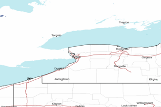
Lake Ontario - Open Waters from Sodus Bay to Mexico Bay Marine Forecast


TONIGHT

SW
WINDS
15 - 25
KNOTS

SUNDAY

W
WINDS
30
KNOTS

SUNDAY NIGHT

W
WINDS
30
KNOTS

MONDAY

SW
WINDS
30
KNOTS

The Marine Weather Forecast In Detail:
LOZ064 Forecast Issued: 341 PM EST Sat Jan 25 2025

GALE WATCH IN EFFECT FROM MONDAY MORNING THROUGH LATE MONDAY NIGHT
Tonight...Southwest Winds 15 To 25 Knots Becoming West To 30 Knots. Scattered Snow Showers This Evening, Then Snow Showers Likely After Midnight. Waves 5 To 9 Feet Building To 9 To 12 Feet. Waves Occasionally Around 15 Feet.
Sunday...West Winds To 30 Knots. Snow Showers Likely In The Morning, Then Lake Effect Snow In The Afternoon. Waves 10 To 14 Feet. Waves Occasionally Around 18 Feet.
Sunday Night...West Winds To 30 Knots Becoming Southwest. Lake Effect Snow Showers Likely. Waves 7 To 11 Feet. Waves Occasionally Around 14 Feet.
Monday...Southwest Winds To 30 Knots Increasing To 40 Knot Gales. A Chance Of Snow Showers. Waves 8 To 12 Feet Building To 12 To 16 Feet. Waves Occasionally Around 20 Feet.
Monday Night...Southwest Gales To 40 Knots Becoming West. Snow Showers Likely In The Evening, Then Snow Overnight. Waves 12 To 17 Feet. Waves Occasionally Around 22 Feet.
Tuesday...Northwest Winds To 30 Knots Becoming Southwest 15 To 25 Knots. Snow Showers Likely. Waves 10 To 14 Feet Subsiding To 3 To 6 Feet. Waves Occasionally Around 18 Feet.
Wednesday...Southwest Winds To 30 Knots Becoming Northwest And Diminishing To 15 To 20 Knots. Snow Showers Likely. Waves 8 To 11 Feet Building To 9 To 13 Feet, Then Subsiding To 5 To 8 Feet. Waves Occasionally Around 16 Feet.
Thursday...Northwest Winds 15 To 20 Knots. A Chance Of Snow Showers. Waves 3 To 6 Feet.
SHARE THIS PAGE:           
Area Forecast Discussion
National Weather Service Buffalo NY
409pm EST Sat Jan 25 2025

Synopsis
Low pressure tracking across Hudson Bay will push its trailing cold front across the area tonight...while generating scattered snow showers and areas of lake enhanced snow east of both lakes. In its wake significant lake effect snow will then continue east of Lake Ontario Sunday into Sunday night...while leftover snow showers wind down east of Lake Erie. Rather unsettled conditions will then arrive Early Next Week
starting off with a period of strong winds on Monday that will either precede or lead into another round of snow and lake enhanced snow Monday night as an arctic cold front crosses our region. Following the passage of the arctic front...leftover snow showers will gradually diminish south of Lake Ontario on Tuesday.

Near Term - Through Sunday
Partial clearing is occurring over Lake Erie before sunset this evening and we are able to see the extent of some of the ice cover on the Lake. GOES GeoColor and visible imagery shows open water along the north and south shorelines of the central part of the lake and more importantly, open water between Long Point to just offshore of Silver Creek.

Low pressure passing well to our north across Hudson Bay will push its trailing cold front east and across our region. Coupled with the passage of an attendant shortwave... this will help to generate some scattered snow showers for the majority of the area. The exceptions to this will be northeast and east of the lakes...where lake enhancement and/or lake effect will lead to areas of more concentrated snow showers/snow. This will be most pronounced northeast and east of Lake Ontario...where a more favorable environment may be enough to support as much as 3 to 6 inches of fresh snowfall by Sunday morning. Off Lake Erie...a much lower cap/shallower moisture and a partial ice covered lake will likely help to hold nighttime accumulations down into the 1 to 3 inch range... with the greatest amounts found across the higher terrain east of the lake.

On Sunday...a general westerly flow across the full fetch of Lake Ontario will allow lake effect snow to become better organized across the Tug Hill Region. The long fetch across the lake... favorable orographic lift supplied by the Tug Hill Plateau...decent background moisture...a cap of around 10-11 kft...and a developing upstream connection to Georgian Bay will all be supportive of significant additional accumulations...with up to another foot of fresh snowfall likely across the Tug Hill. Meanwhile east of Lake Erie...a much drier environment and further lowering of the already- low cap will result in numerous lighter snow showers in the morning becoming more scattered by the afternoon. These will produce another inch or two of accumulation across the higher terrain east of the lake.

Outside of the above lake effect areas...Sunday will be largely dry with high temps ranging from the mid 20s to lower 30s...along with brisk westerly winds gusting to between 25-35 mph at times.

Short Term - Sunday Night Through Tuesday
***A PERIOD OF HIGH WINDS AND IMPACTFUL SNOWFALL POSSIBLE***

Lake effect snow will continue Sunday night off Lake Ontario, while just some scattered light lake induced snow showers remain northeast of Lake Erie. EL around 5kft east of Lake Ontario Sunday evening, but will slowly lower through the overnight, finally ending the event by Monday morning. Dry weather outside of lake effect, but winds will be on the increase through the night. Lows will be mainly in the teens to around 20.

Other than a few lingering lake effect snow showers northeast of Lake Ontario Monday morning, expecting a mainly dry start to the work week, although snow showers ahead of an Arctic front approaching from the north may reach as far south as the North Country by late in the day. The much bigger story will be the potential for high winds. An already strong area of low pressure (975mb) over James Bay will continue to strengthen (possibly to sub 970mb) as it slides east into west-central Quebec by late Monday. A very strong associated southwesterly LLJ (60-70 knots) just off the deck will pivot across the area Monday afternoon into the first half of Monday night bringing the potential for very strong winds, especially from the Lake Erie shoreline northeastward across the Niagara Frontier and over to Monroe County...and also across Jefferson County. With this in mind, have added Jefferson County to the existing High Wind Watch (7am Monday to 6am Tuesday). This is far from a climatologically favorable low track to bring high winds to our forecast area. Another negative factor is the weak to neutral advection pattern that will be in place when the strongest LLJ is overhead. That said, BUFKIT soundings and model consensus continues to show the potential for wind gusts over 50 mph. High temperatures mid 20s to low 30s.

Strong winds will continue into Monday night, however these strong winds will now combine with an impactful accumulating burst of snow across the area as the strong Arctic front approaches then moves across the area overnight, with the potential for snow squalls as well. Most areas will see a quick 1-3 inches within the burst of snow, however greater amounts look possible east of Lake Ontario, especially across the Tug Hill/western Dacks. Low temperatures teens North Country with low to mid 20s elsewhere.

Arctic boundary now looks as though it should push south of our entire area by around Tuesday morning, a bit quicker than previously thought. Winds will turn northwesterly and slowly weaken through the day. However, it will still be blustery, and when combined with falling temps (non-diurnal) under a strong Cold Air Advection regime behind the Arctic boundary...expect very cold wind chills. There will be some lingering snow south of Lake Ontario Tuesday morning just behind the boundary associated with a lagging shortwave that may produce an additional inch or so before ending. Very brief break possible Tuesday afternoon, before an approaching Clipper system brings the next chance for some light snow by very late Tuesday or Tuesday evening.

Long Term - Tuesday Night Through Saturday
To open this period, a strong clipper low will advance across our region. There is still a bit of uncertainty to its track...which will have an influence on the temperatures as well as wind potential for this event. The lower level jet is not forecasted to be as strong as this Monday's event...with this jet to be around 40 knots...with the higher flow undercutting our region to the south.

Warm air advection snow will spread across the region Tuesday night, this along with rising temperatures overnight. A cold front swinging across the state Wednesday will bring another burst of snow, that could be squally depending upon the track of the surface low. Could see temperatures ahead of this front, and south of the surface low track reach or even exceed the freezing mark for WNY. Behind this front strong cold air advection will bring burst of lake effect snow Wednesday night through Thursday night...and not until the surface and mid level ridge axis passes Friday that light snow showers and flurries will eventually end downwind of the lakes. Highs Thursday and Friday will be in the teens to lower 20s, with brisk northwest winds making for wind chills in the single digits through the day.

Winds slacken and temperatures drop Friday night with the surface ridge axis entering our region.

Behind what could be a 1040 mb surface ridge, breezy, southerly flow on Saturday will send temperatures for many to the freezing mark with lower elevations likely to be well and above freezing with temperatures in the mid to upper 30s.

Marine
Strong southwesterlies tonight will become westerly later tonight and Sunday following the passage of a cold front. This will support widespread small craft advisories through the weekend.

On Monday...a deep storm system passing by well to the north of Lake Ontario will likely generate gale force winds throughout the region. A gale watch therefore remains in effect for both lakes for Monday and Monday night.

NOAA Buffalo NY Office: Watches - Warnings - Advisories
NY...High Wind Watch from Monday morning through late Monday night for NYZ001>003-007-010>012-019-085. Lake Effect Snow Warning from 10pm this evening to 6am EST Monday for NYZ006>008.

Marine
Small Craft Advisory until 10am EST Sunday for LEZ020. Gale Watch from Monday morning through late Monday night for LEZ020-040-041. Small Craft Advisory until 7am EST Monday for LEZ040-041. Gale Watch from Monday morning through late Monday night for LOZ042>045-062>065. Small Craft Advisory until 7am EST Monday for LOZ042-045. Small Craft Advisory until 7am EST Monday for LOZ043-044.

markerCities        markerTides        marker This Coastal Forecast
NEARBY TIDES: