Point Arena to Pigeon Point between 60 and 150 NM Offshore Forecast
| Today...N Winds 20 To 25 Kt. Seas 9 To 11 Ft. |
| Tonight...N To Nw Winds 20 To 25 Kt. Seas 8 To 10 Ft. |
| Sat...N To Nw Winds 15 To 25 Kt. Seas 8 To 10 Ft. |
| Sat Night...N Winds 15 To 20 Kt, Becoming Nw 10 To 15 Kt. Seas 7 To 9 Ft. |
| Sun...Nw Winds 10 To 15 Kt. Seas 7 To 8 Ft. |
| Sun Night...W Winds 5 To 10 Kt. Seas 7 To 8 Ft. |
| Mon...W Winds 5 To 10 Kt, Becoming Variable. Seas 7 To 8 Ft. |
| Mon Night...W To Nw Winds 5 To 10 Kt. Seas 6 To 8 Ft. |
| Tue...Nw Winds 5 To 10 Kt. Seas 6 To 7 Ft. |
| Tue Night...Nw Winds 10 To 15 Kt. Seas 5 To 6 Ft. |
| Area Forecast Discussion National Weather Service San Francisco CA 1138am PDT Fri May 1 2026 .SHORT TERM... Issued at 149am PDT Fri May 1 2026 (Today and tonight) Steady and cool northwest winds continue over the coastal waters with sea surface temperatures varying from 54F to 59F (~ 2F to 3F above May normals). Coastal stratus continues to develop with an inland intrusion taking place per satellite and surface observations. A lower to mid level thermal ridge is capping stratus clouds while a clear sky above is allowing nocturnal radiative cooling. Currently, a 500 mb height ridge extends from the eastern Pacific to northern California, the Pacific Northwest, Alberta and Saskatchewan. Air temperatures currently vary from the mid 40s to 50s in the lower elevations to the 60s in the higher elevations, where it's milder within the lower level temperature inversion. Stratus clouds will clear to the coastline under peak diurnal mixing later today. Daytime highs will climb a few degrees above early May normals inland to near normal along the immediate coast. High temperatures will vary from the 60s coastside, 70s bayside to the lower to mid 80s far inland. Tonight, the aforementioned 500 mb ridge will shift eastward and weaken allowing for cooling aloft to commence. Coastal stratus redevelopment and onshore breezes will potentially usher stratus farther inland tonight and Saturday morning. Long Term Issued at 149am PDT Fri May 1 2026 (Saturday through Thursday) An eastward moving 500 mb open wave trough approaching the Pacific Northwest will close off by late today. Behind the 500 mb trough a sharpening 500 mb ridge will become unstable, further supporting the closing off 500 mb low. This often happens when polar jet stream winds are unable to follow sharp 500 mb ridge contours, first heading eastward then flowing back westward, carving out and closing off a 500 mb low to the south. This 500 mb low will move south while the 500 mb ridge also closes off to the north, forming a Rex block pattern over the weekend and early next week. Dynamic cooling aloft with lowering 500 mb heigheights over our area will deepen the marine layer, with further cooling taking place and potentially producing periodic light drizzle and/or light rain. It's a low confidence forecast in terms of how much precipitation may result. At the moment it does not look like very much i.e. up to a few hundredths; model forecasts are varying in solutions. Stay tuned to updates. The Rex block is not forecast to last very long, it's likely to begin weakening and breaking down by the middle of next week. The subtropical jet stream attaches to the base of the closed 500 mb low over the weekend and early next week assisting with ejecting the low eastward mid to late next week. Btw, the strength of the subtropical jet stream is likely in response to recent surface water warming over lower latitudes. The 500 mb low getting picked up by the subtropical jet stream allows the polar jet stream over the Pacific to help move things along to the east as well, ushering in a newly arriving 500 mb mid-latitude trough with the potential for showery weather over northern California late next week. Marine (Today through Wednesday) Issued at 451am PDT Fri May 1 2026 A fresh to strong northwesterly breeze continues into Saturday before winds diminish, becoming moderate to fresh, late Saturday into Sunday. Moderate, wind driven, seas will build to 10 to 12 feet across the northern outer waters and 8 to 10 feet across the rest of the waters today through Saturday afternoon. Seas subside late Saturday into Sunday as winds continue to diminish next week. NOAA San Francisco Bay Area Office: Watches - Warnings - Advisories CA...Beach Hazards Statement from Saturday morning through Sunday evening for CAZ006-505-509-529-530. PZ...Small Craft Advisory from 3pm this afternoon to 9pm PDT this evening for Pt Arena to Pt Reyes 0-10 nm. Small Craft Advisory until 9am PDT Saturday for Pt Arena to Pt Reyes 10-60 NM. x.com/nwsbayarea |
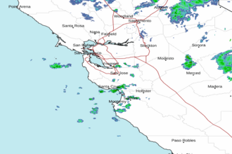
 San Francisco Radar
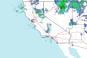
 Southwest Radar