Bonita Beach to Englewood FL out 20 - 60 NM Marine Forecast
| Overnight...East Winds 5 To 10 Knots. Seas Around 2 Feet. Wave Detail: East 1 Foot At 4 Seconds. |
| Thursday...East Winds 10 To 15 Knots With Gusts Up To 20 Knots, Diminishing To 5 To 10 Knots In The Afternoon. Seas Around 2 Feet. Wave Detail: East 2 Feet At 4 Seconds. |
| Thursday Night...East Winds 5 To 10 Knots, Increasing To 10 To 15 Knots With Gusts Up To 20 Knots After Midnight. Seas Around 2 Feet. Wave Detail: East 2 Feet At 4 Seconds. A Slight Chance Of Thunderstorms In The Evening. A Slight Chance Of Showers. |
| Friday...East Winds 10 To 15 Knots, Diminishing To 5 To 10 Knots In The Afternoon. Seas 2 To 3 Feet. Wave Detail: Southeast 2 Feet At 4 Seconds. |
| Friday Night...East Winds 5 To 10 Knots, Increasing To 10 To 15 Knots With Gusts Up To 20 Knots After Midnight. Seas 2 To 3 Feet. Wave Detail: Southeast 2 Feet At 6 Seconds. |
| Saturday...East Winds 10 To 15 Knots With Gusts Up To 20 Knots, Diminishing To 5 To 10 Knots In The Afternoon. Seas 2 To 3 Feet. Wave Detail: Southeast 2 Feet At 6 Seconds And East 1 Foot At 3 Seconds. |
| Saturday Night...Northeast Winds 5 To 10 Knots. Seas Around 2 Feet. |
| Sunday...East Winds 5 To 10 Knots, Becoming North In The Afternoon. Seas Around 2 Feet. |
| Sunday Night...North Winds 5 To 10 Knots. Seas 1 Foot Or Less. |
| Monday...North Winds 5 To 10 Knots. Seas 1 Foot Or Less. A Slight Chance Of Showers In The Afternoon. Winds And Seas Higher In And Near Thunderstorms. |
| Area Forecast Discussion National Weather Service Tampa Bay Ruskin FL 841pm EDT Wednesday April 1 2026 ...New .KEY MESSAGES... - Isolated to scattered showers and thunderstorms through the week. - Moderate to extreme drought conditions continue. Issued at 840pm EDT Wednesday April 1 2026 Some scattered low-topped shower activity continues to move offshore this evening with most land areas dry at this point. Additional precipitation is not expected through the remainder of the evening and overnight hours with mainly clear skies and overnight lows dropping to the upper 50s to the mid 60s. Other some minor tweaks to Probability of Precipitation this evening based on latest radar trends, the forecast remains on track at this time. Issued at 223pm EDT Wednesday April 1 2026 Today is shaping up to be a mostly dry and hot day with only a few showers possible this afternoon and evening. Tomorrow will look a little different with an increase in moisture in the mid levels moving over the state. As it does so it will allow for scattered showers and isolated thunderstorms to form during the afternoon and evening hours. With our easterly flow still in place we can expect these showers to move from east to west during the day. Our mid levels quickly dry back out for Friday and into the weekend. This will keep showers to a minimum with only a 20 to 30 percent chances each afternoon and evening. Temperatures will remain warm with highs around 90 degrees both Saturday and Sunday for most of the area. By next Monday a frontal boundary will start to slow down over North Florida resulting in increased moisture and better shower chances throughout the day. This front will slow drift south Monday night and stall over the area Tuesday. Right now models are showing a cloudy day with light on and off showers. This gloomy day will also result in temperatures staying in the mid to upper 70's for highs. Marine Issued at 223pm EDT Wednesday April 1 2026 Ridging will remain over the area through the weekend keeping winds out of the east. Winds will increase slightly to 10 to 15 knots for Thursday through Saturday before coming back down to 5 to 10 for Sunday. Our best chance of showers and storms will be Thursday evening as storms push off the coast. Fire Weather Issued at 223pm EDT Wednesday April 1 2026 RH will remain above critical levels through the period. The best chance of rain through the weekend will be on Thursday as increase moisture will allow for scattered showers and isolated thunderstorms through the afternoon and evening hours. NOAA Tampa FL Office: Watches - Warnings - Advisories FL...None. Gulf waters...None. |
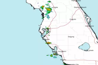 Tampa Bay FL Radar
 Gulf Radar