Cape Shoalwater WA to Cascade Head OR from 10 to 60 NM Marine Forecast
| Rest Of Today...S Wind 5 Kt. Wind Waves S 1 Ft At 4 Seconds. Nw Swell 2 Ft At 9 Seconds. Widespread Dense Fog And A Chance Of Showers In The Morning, Then Areas Of Dense Fog In The Afternoon. |
| Tonight...N Wind 5 Kt. Wind Waves N 1 Ft At 4 Seconds. Nw Swell 2 Ft At 9 Seconds. Areas Of Dense Fog In The Evening. Patchy Dense Fog After Midnight. |
| Wed...Ne Wind 5 Kt. Wind Waves Ne 1 Ft At 4 Seconds. Nw Swell 3 Ft At 9 Seconds. Patchy Dense Fog In The Morning. |
| Wed Night...Ne Wind 5 Kt. Wind Waves Ne 1 Ft At 4 Seconds. Nw Swell 3 Ft At 9 Seconds. |
| Thu...Se Wind 5 Kt. Wind Waves Se 2 Ft At 4 Seconds. Nw Swell 3 Ft At 10 Seconds. |
| Thu Night...Nw Wind 5 To 10 Kt. Wind Waves Nw 2 Ft At 4 Seconds. Nw Swell 3 Ft At 10 Seconds. |
| Fri...Nw Wind 5 To 10 Kt. Wind Waves 2 Ft. Nw Swell 4 Ft. |
| Sat...Nw Wind 5 To 10 Kt. Wind Waves 2 Ft. Nw Swell 4 Ft. |
| Area Forecast Discussion ...Updated National Weather Service Portland OR 852pm PDT Sunday April 28 2024 Made some updates to the forecast this afternoon and evening, mostly to remove the thunder mention for this evening as the 00z KSLE sounding confirms a strong mid-level capping inversion holding most cloud tops to around 10 kft...too shallow to achieve charge separation. Not sure why the NBM was so intent on holding on to thunder chances this afternoon and evening, as the 12z HREF showed nearly 0 percent chances of lightning and Storm Prediction Center SREF calibrated thunder didn't show much more. Ironically, thunder chances may actually improve overnight and into Monday morning as a pocket of sub-minus 30 deg C air at 500 mb swings across the forecast area, especially along the coast where temps likely remain a touch milder overnight. This cold pocket aloft will be accompanied by the left exit region of a 100 kt jet, which should also enhance lift early Monday morning. At the very least, expect a significant uptick in shower activity early Monday morning, with these showers moving into the Cascades while snow levels lower from around 4000 ft to around 2500 ft. While few changes to Quantitative Precipitation Forecast were made, the NBM snow ratios of up to 17:1 for the Cascade passes Monday morning look a bit excessive. We nearly halved these, given the strong late April sunshine as Monday progresses and marginal temperatures anyway. Snow ratios of that magnitude would be impressive for mid-winter, so it seems suspect that they would occur during a late season event with marginal temperatures. The resulting snow amounts are still enough to get us into advisory criteria, especially above 3000-3500 feet where 3-8 inches can be expected. At elevations where it is snowing now (generally 5500 ft and above), snow totals may exceed 8 inches as they will see all snow from this point forward in the event. Latest high-res models suggest shower activity will remain plentiful through midday before becoming more spotty, so we extended the Winter Weather Advisories through 2pm Monday for all our high Cascades zones. Aviation discussion has also been updated below. Weagle Synopsis Multiple colder weather systems to move through NW Oregon and SW Washington tonight into Monday morning and again Monday night into Tuesday, bringing continuing showers along with chances of isolated thunderstorms. Snow levels drop tonight down to 2500-3000 feet by tomorrow morning with snow at times expected over the Cascades through Tuesday. Dry and warmer weather returns Wednesday with unsettled weather returning late this week into the weekend. .SHORT TERM...Sunday afternoon through Wednesday...Radar imagery early Sunday afternoon shows showers are becoming more widespread across NW Oregon and SW Washington as the next weather system approaches the region. This upper trough and associated surface front are slated to move through the region late tonight into early Monday quickly followed by another weather system Monday night into Tuesday. Showers are expected to continue into Tuesday with these systems. The IVT associated with these are very low (less than 250 kg/ms), so expecting mostly showers instead of stratiform rain through Tuesday. A few bands of moderate rain are possible ahead of and along each front, with the Monday night through Tuesday front packing a little more punch. Current Quantitative Precipitation Forecast through 5pm Monday is 0.1-0.3 inch for the inland valleys and 0.4-1 inch for the coast and mountains. Additional Quantitative Precipitation Forecast through 5am Wednesday is 0.25-0.5 inch for inland valleys and 0.3-1.25 inch for the coast and mountains. For both systems, Lane county is expected to be on the lower end of these estimates as the strongest portion of each system remains north of Lane county. These are colder systems as they originate from west of Alaska, and as such they is forecast to bring colder air aloft into the region. Latest observations indicate this colder air aloft is beginning to push into the region this afternoon, with colder temperature expected tomorrow into Tuesday. This will cause both thunderstorm chances and lower snow levels. First, as colder air moves in aloft, instability is forecast to increase. This afternoon only has a weak chance of isolated thunderstorms with CAPE values only expected to increase to 150-250 J/kg, mainly along and north of the Columbia River, including the Portland/Vancouver metro area, and the north Oregon coast and Cascades. There are better chances for isolated thunderstorms across the region both tomorrow and Tuesday along and behind each frontal passage with CAPE values increasing to 200-400 J/kg and 0-6 km shear of 45-55 kts. Heavy rain, small hail, gusty winds, and lightning are the main impacts expected with any strong shower or thunderstorm that forms. Additionally, snow levels will begin dropping this evening into Monday as the cold air continues moving into the region. Expect snow levels to fall to 3500-4000 ft by this evening and 2500-3000 ft by tomorrow morning. As there will be a couple decent shots of precipitation with the front, expecting snow amounts of 2-8 inches above 2500 ft with up to 10-14 inches above 5000 ft. Elevations down to 2000 ft could see a dusting to an inch or so, especially in heavier showers. A Winter Weather Advisory remains in effect for the Cascades through tomorrow morning. Lighter snow is expected to continue tomorrow afternoon through Tuesday, though since conditions will turn to more scattered showers, there will likely not be much widespread additional accumulation except for potentially Tuesday morning with the second frontal passage. Daytime temperatures are forecast to remain fairly steady in the mid to upper 50s for the lowlands and 30s to low 40s for the higher terrain. Nighttime temperatures will cool a bit each day, with morning lows tomorrow down to the low 40s for the lowlands then potentially falling to the upper 30s for Tuesday and Wednesday mornings. May need to keep an eye out for frost potential Wednesday morning if clouds clear out enough for radiative cooling, especially in the outlying valley areas and the Coast Range. Could also see some locally breezy winds at times with each frontal passage with brief periods of gusts up to 20-25 mph, locally up to 30 mph along the coast and 40-45 mph over the high Cascades. By Wednesday, ensemble guidance agreement continues in increase in dry weather returning as ridging builds, though there is uncertainty on whether this dry period will last beyond Wednesday. More details on that below in the Long Term discussion. However, temperatures are forecast to warm back near seasonal normals for late April with NBM indicating 70-90% probability of temperatures rising back into the 60s. -HEC Long Term Thursday through next Sunday...Forecast confidence continues to drop off dramatically after the midweek period as guidance struggles with how to handle multiple disturbances presently over the west and central north Pacific. As longwave troughing exits the western US, it remains uncertain whether the next weaker system will maintain enough momentum to bring rain to SW Washington and NW Oregon. Latest NBM guidance basically shows a 50/50 chance of some light precipitation Thursday, then suggests a drier period of uncertain length. For Friday, 12z LREF grand ensemble shows a fairly normal distribution of 850 mb temps between 0 deg C and +10 deg C, with about 50% of members falling between +4 and +7 deg C. The majority of EC/GFS/CMC ensemble members want to bring troughing back to the Pac NW by next weekend, with cool/unsettled weather returning. However this is far from certain. While 20% of NBM members suggest high temps Friday will fail to reach 65 def F in the Willamette Valley, another 20% suggest highs will reach 80 deg F for the PDX metro. For Saturday, 20-30% of members suggest the Willamette Valley will reach the 70s, while 10% suggest another day reaching 80 degrees for the PDX metro. While our forecast is much closer to seasonal norms than the warmer members, with cooler/wetter weather returning by the weekend, the warmer members illustrate how there is still potential for upper ridging to hold on longer than what the majority of members and ensemble means suggest. Weagle Marine Active weather is expected to continue into midweek. A surface front moving through the waters this evening through early Monday will bring another round of elevated winds along with steep and choppy seas through midday Monday. Generally westerly winds with gusts up to 25 kt and seas of 6 to 9 ft at 10 to 13 seconds through Monday. A Small Craft Advisory remains in effect through Monday afternoon. A series of weak fronts will move through the waters Monday night into Tuesday and again late Tuesday into Wednesday, bringing elevated winds and seas at times. Some models are suggesting that small craft conditions could develop with each frontal passage. Will continue to monitor the situation as it develops. -HEC NOAA Portland OR Office: Watches - Warnings - Advisories OR...Winter Weather Advisory until 2pm PDT Monday for ORZ126>128. WA...Winter Weather Advisory until 2pm PDT Monday for WAZ211. PZ...Small Craft Advisory until 11pm PDT Tuesday for PZZ210-251>253- 271>273. |
 Portland OR Radar
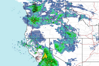 Northwest Radar