Jupiter Inlet to Deerfield Beach, FL out 20 - 60 NM Marine Forecast
| Tonight...E Winds 15 To 20 Kt. Seas 3 To 4 Ft, Occasionally To 5 Ft. Wave Detail: E 4 Ft At 5 Seconds And Nw 1 Foot At 7 Seconds. Intracoastal Waters Choppy In Exposed Areas. A Slight Chance Of Showers And Tstms Late. |
| Thu...E Winds 15 To 20 Kt. Seas 4 To 5 Ft, Occasionally To 6 Ft. Wave Detail: E 5 Ft At 5 Seconds And Nw 1 Foot At 6 Seconds. Intracoastal Waters Choppy In Exposed Areas. A Chance Of Showers In The Morning. |
| Thu Night...E Winds 15 To 20 Kt With Gusts Up To 25 Kt. Seas 4 To 5 Ft, Occasionally To 6 Ft. Wave Detail: E 5 Ft At 6 Seconds And Nw 1 Foot At 6 Seconds. Intracoastal Waters Choppy In Exposed Areas. |
| Fri...E Winds 15 To 20 Kt. Seas 4 To 5 Ft, Occasionally To 6 Ft. Wave Detail: E 5 Ft At 6 Seconds And Nw 1 Foot At 6 Seconds. Intracoastal Waters Choppy In Exposed Areas. |
| Fri Night...E Winds Around 20 Kt With Gusts Up To 25 Kt. Seas 4 To 6 Ft, Occasionally To 8 Ft. Wave Detail: E 5 Ft At 6 Seconds And Nw 1 Foot At 6 Seconds. Intracoastal Waters Choppy In Exposed Areas. |
| Sat And Sat Night...E Winds 15 To 20 Kt With Gusts Up To 25 Kt. Seas 4 To 5 Ft, Occasionally To 6 Ft. Wave Detail: E 5 Ft At 6 Seconds And Nw 1 Foot At 6 Seconds. Intracoastal Waters Choppy In Exposed Areas. A Chance Of Showers. |
| Sun...E Winds 10 To 15 Kt, Becoming Se 5 To 10 Kt After Midnight. Seas 2 To 4 Ft, Occasionally To 5 Ft. Intracoastal Waters A Moderate Chop. |
| Mon...E Winds 5 To 10 Kt, Increasing To 10 To 15 Kt. Seas 2 To 3 Ft. Intracoastal Waters A Moderate Chop. A Chance Of Showers. Winds And Seas Higher In And Near Tstms. |
| Area Forecast Discussion National Weather Service Miami FL 124am EDT Thu April 2 2026 .SHORT TERM... (Today through Thursday) Issued at 111am EDT Wednesday April 1 2026 Deep-layer ridging remains entrenched across South Florida early this morning as the combination of a departing mid-level ridge axis and the continued expansion of a large sprawling surface high into South Florida will result in much of the same; mainly dry and quiet weather. ACARS profiles and upper air soundings continue to depict a stout subsidence inversion which will once again limit the spatial and temporal extent of any shower activity, keeping activity isolated and low-topped in nature as copious amounts of dry air remains throughout much of the vertical column. As the high pressure at the surface continues to dominate the weather pattern within the lowest 1km of the atmosphere, the pressure gradient will weaken slightly but still produce breezy easterly winds throughout the course of today. Recent radar trends have depicted the development of a few isolated showers over the warm Gulfstream waters quickly advecting east to west into portions of the eastern half of South Florida. These brisk low-topped showers will continue across the Gulfstream waters and southeastern Florida through daybreak before the mixing down of mid-level dry air in tandem with drier low level boundary air advecting in from the east, should focus any sporadic diurnal activity across inland and western areas later in the day. Aloft, the axis of mid-level ridging will continue to advect further into the western Atlantic waters & northwestern Bahamas, gradually elongating and becoming increasingly diffuse as the day progresses. A plume of deeper atmospheric moisture (in tandem with perhaps a very weak surface trough as a very slight perturbation in the surface wind field is depicted on numerical guidance) is forecast to push into the region from the east tonight which may raise shower chances once again across the eastern half of the region overnight into early Thursday. The forecast gets a little more interesting during the day on Thursday as the arrival of a surface moisture plume (forecast precipitable water values increase to 1.3 to 1.5 inches) coincides with the arrival of colder 500mb values associated with a mid-level impulse/cut-off low that is forecast to transit near or just to the south of our region. The colder values aloft will act to steepen mid- level lapse rates to 6.0 to 6.5 C/km as 500mb temperatures cool to -11C to -13C which will be between the 10th and 25th percentile for the date. RAP & HRRR (High-Resolution Rapid Refresh) forecast soundings for Thursday afternoon depict marginal instability with an inverted V type setup as copious amounts of dry air will remain present. While morning activity is forecast to concentrate along the immediate east coast of South Florida, a non-zero conditional threat of marginal severe hail and isolated strong to severe wind gusts will exist on Thursday afternoon near Lake Okeechobee and southwestern Florida as the easterly breeze pushes convective activity westward. A potential fail mode for the conditional setup of one or two strong to marginally severe storms will be the development of widespread convection and cloud cover preventing any development of taller discrete cores. A temperature gradient will remain across the region both this afternoon and once again on Thursday with high temperatures in the upper 70s to low 80s across the eastern half of the peninsula due to the cooling aspects of the ocean breeze and the western half of the peninsula peaking in the mid 80s. Overnight temperatures will be inverse as the ocean breeze will keep warm and muggy conditons along the east coast with low temps in the 70s whereas inland and western locales will see low temperatures dip into the widespread 60s, even low 60s across cool spots across inland southwestern Florida. Long Term (Thursday night through Tuesday) Issued at 111am EDT Wednesday April 1 2026 Deterministic and ensemble guidance depict the continuation of a cold pool aloft on Friday and Saturday as the mid-level impulse/cut-off low gradually slides eastward over (American model solution) or just south of the region (European model solution) into the western Atlantic. The expansive surface high across the western Atlantic will remain in firm control at the surface as the persistent moderate easterly breeze continues into Saturday. After the moisture surge on Thursday, model guidance depicts the advection of a drier airmass on Friday and Saturday which will result in a reduction of rain chances both days. The instability laden waters of the Gulfstream will result in a maxima of shower activity over the Atlantic waters and east coast of South Florida each night before diurnal activity focuses across inland and western half of South Florida. Although temperatures will remain cooler aloft, the drier air at the surface may result in rain chances remaining in the 20- 30% range on Friday and Saturday. By Sunday, model guidance depicts the cut-off low beginning to lift northwards across the western Atlantic waters and northwestern Bahamas. 500mb flow over South Florida is forecast to veer out of a northerly direction on the western side of this feature as 500mb temperatures also begin to rebound/increase. Interestingly, this is where our two major model camps begin to have a notable disagreement as the European model shows an surface area of low pressure developing underneath the cut-off low and lifting northwards just to the east of South Florida. This would act to advect drier low-level air into the region from the north via cyclonic flow around this feature. The American model is much slower in the development of the surface low which results in deeper atmospheric moisture being able to rotate into the region during the second half of the weekend before the surface low lifts northwards in tandem with the cut-off low. Rain chances will depend on the evolution of any surface low as that will directly impact how much moisture arrives into the region as well as the direction of prevailing surface winds. Towards the tail end of the extended period, model guidance depicts the advection of a strong mid-level trough propagating across the eastern United States in tandem with a frontal boundary moving southwards across the southeastern United States into Florida. While it remains to be seen if a frontal passage or stall will occur, a period of higher rain chances and cooler temperatures could occur during the early to mid week portion of next week. Marine Issued at 111am EDT Wednesday April 1 2026 A moderate to strong easterly breeze will continue across the Atlantic waters during the remainder of the week into the first half of the upcoming weekend. While winds are currently below Small Craft Advisory criteria, model guidance hints at a strengthening of winds Thursday into Friday which may prompt the issuance of a new Small Craft Advisory for the Atlantic and Biscayne Bay waters. Seas across the Atlantic waters will mainly remain in the 4-6 ft range for the remainder of the work week with wave heigheights forecast to remain in the 2-3 ft range across the local Gulf waters. Elevated winds and waves will be possible in and around any shower or thunderstorm activity, especially on Thursday. Beaches Issued at 111am EDT Wednesday April 1 2026 Dangerous rip currents will continue at all Atlantic beaches through the remainder of the work week as strong onshore winds persist. Always swim at a guarded beach and when in doubt, don't venture out! NOAA Miami FL Office: Watches - Warnings - Advisories FL...High Rip Current Risk through Friday evening for FLZ168-172-173. AM...None. GM...None. |
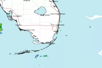 Miami FL Radar
 Southeast Radar
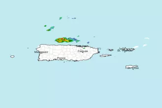 San Juan Radar
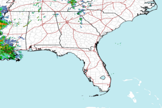 Southeast Radar