San Juan Islands and Northern Inland Waters Marine Forecast
| Today...W Wind To 10 Kt Becoming Sw 5 To 15 Kt In The Afternoon. Wind Waves 2 Ft Or Less. |
| Tonight...Sw Wind 5 To 15 Kt. Wind Waves 2 Ft Or Less. |
| Tue...Se Wind To 10 Kt Becoming W In The Afternoon. Wind Waves 1 Ft Or Less. |
| Tue Night...Sw Wind 5 To 15 Kt. Wind Waves 2 Ft Or Less. |
| Wed...S Wind To 10 Kt Becoming 5 To 15 Kt In The Afternoon. Wind Waves 2 Ft Or Less. |
| Wed Night...S Wind To 10 Kt. Wind Waves 1 Ft Or Less. |
| Thu...E Wind 5 To 15 Kt Becoming Nw To 10 Kt. Wind Waves 2 Ft Or Less. |
| Fri...Light Wind Becoming Ne To 10 Kt. Wind Waves Less Than 1 Ft Becoming 1 Ft Or Less. |
| Area Forecast Discussion National Weather Service Seattle WA 858pm PDT Sunday April 28 2024 Synopsis Unsettled, cool weather continues with a series of frontal systems crossing the region through the middle of the week. A brief warming and drying is expected midweek before conditions turn unsettled again late week. .Short Term - Tonight through Wednesday Showers associated with an upper level trough over the area continue as per latest radar loop. The strongest echoes are occurring over portions of the north Sound as well as western Skagit and Snohomish counties. Current IR satellite imagery does an excellent job of highlighting the PSCZ nature of this increased activity. What will be interesting to see is how precipitation amounts will be impacted as this feature starts to bleed eastward over the Cascades. The timing for this still seems to be on track with the overnight hours and thusly falling under the purview of the inherited Winter Weather Advisory...which, having said all this...looks to be in good shape with no need for alteration or updating. Soggy though it may be, forecast is holding true and as such no need for any evening updates to public products at this time. For additional forecast details, please refer to the Previous Discussion section below. From Previous Discussion...Scattered showers continue to spread onshore across Western Washington this afternoon as an upper trough west of Haida Gwaii digs southward toward the region. Cooling temperatures aloft will lead to increasing instability late today into Monday for a chance of thunderstorms as well as snow levels dipping to most pass levels late tonight. A Winter Weather Advisory continues for the Cascades above 3500 feet late tonight into Monday morning. Another upper trough digs southward across the area Monday night into early Tuesday. The focus with that system continues to be a bit further southward...with much of the Quantitative Precipitation Forecast from the Seattle area southward. The trough axis shifts east of the area by late Tuesday afternoon as drier north-northwest flow aloft develops ahead of a weak upper ridge offshore. As things presently stand, Wednesday is shaping up to be one of the nicest days of the week as weak ridging aloft leads to mostly dry conditions, some sunshine, and high temperatures bouncing back to near seasonal norms. Long Term - Thursday Through Sunday From Previous Discussion...The woes of deciphering the extended portion of the forecast continue. There is general agreement that another upper trough crossing southern British Columbia on Thursday will bring a returning chance of showers. Uncertainty in the forecast for Friday into next weekend increases by the day. The Euro ensembles favor additional troughing and cool temperatures while the more optimistic GFS (Global Forecast System) ensemble mean has weak upper ridging and temperatures climbing a little above normal. The NBM 10th and 90th percentile high temperature forecasts have a 10 to 15 degree spread by Friday and Saturday. Given these levels of uncertainty, near climo temps and a generic chance of showers forecast late in the week is the best forecast at this stage. 27 Marine Yet another disturbance continues to maintain gusty advisory strength winds through the central and eastern Strait of Juan de Fuca and into the adjacent interior waters this evening. Meanwhile, seas holding around 9 to 10 ft with a dominant period around 10 seconds will maintain rather steep conditions over the coastal waters tonight. While winds are expected to gradually trend down, the potential for localized gusts to 25-30 kt under strong showers or isolated thunderstorms will continue into Monday. Another front arrives Monday night into Tuesday for another round of more widespread advisory strength winds. Seas across the coastal waters will generally remain near or just below 10 ft through the next couple of days, before subsiding more significantly toward midweek. Hydrology No river flooding is anticipated over the next seven days. NOAA Seattle WA Office: Watches - Warnings - Advisories WA...Winter Weather Advisory from 11pm this evening to 11am PDT Monday for West Slopes North Cascades and Passes-West Slopes North Central Cascades and Passes-West Slopes South Central Cascades and Passes. PZ...Small Craft Advisory until 5am PDT Monday for Central U.S. Waters Strait Of Juan De Fuca- East Entrance U.S. Waters Strait Of Juan De Fuca. Small Craft Advisory until 11pm PDT this evening for Northern Inland Waters Including The San Juan Islands. Small Craft Advisory until 8pm PDT this evening for Puget Sound and Hood Canal |
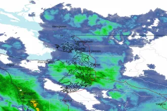 Seattle/Tacoma WA Radar
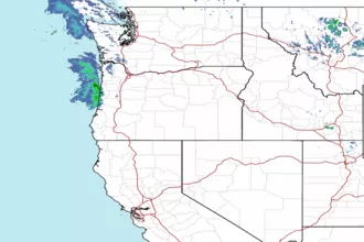 Northwest Radar