Central U.S. Waters Strait of Juan de Fuca Marine Forecast
| Today...W Wind Around 5 Kt, Rising To 10 To 15 Kt Late. Waves Around 2 Ft Or Less. |
| Tonight...W Wind 10 To 15 Kt. Waves Around 3 Ft. |
| Wed...W Wind 5 To 10 Kt, Rising To 10 To 15 Kt In The Afternoon. Waves Around 2 Ft Or Less. |
| Wed Night...W Wind 10 To 15 Kt. Waves Around 3 Ft. A Chance Of Rain After Midnight. |
| Thu...W Wind 5 To 10 Kt. Waves Around 2 Ft Or Less. A Chance Of Rain In The Morning, Then Rain Likely In The Afternoon. |
| Thu Night...W Wind 10 To 15 Kt. Waves Around 2 Ft Or Less, Then Around 3 Ft After Midnight. Rain Likely, Mainly In The Evening. |
| Fri...W Wind 5 To 10 Kt. Waves Around 2 Ft Or Less. |
| Fri Night...W Wind 10 To 15 Kt. Waves Around 3 Ft. |
| Sat...W Wind 5 To 10 Kt. Waves Around 2 Ft Or Less. |
| Sat Night...W Wind 10 To 15 Kt, Easing To 5 To 10 Kt After Midnight. Waves Around 3 Ft. |
| Area Forecast Discussion National Weather Service Seattle WA 949am PDT Tuesday July 14 2026 Synopsis High pressure aloft will remain over the region into Wednesday for continued warm and drier conditions. An area of low pressure may bring a threat of showers and thunderstorms around Thursday before high pressure regains control over the weekend for a return of dry conditions and well above normal temperatures. Short Term - Today through Thursday Clouds have scattered out this morning across the coastline and the Cascades giving way for clear skies across Western Washington this morning. Otherwise, no significant updates to the forecast this morning. An upper level ridge centered over the Rockies will remain the dominant factor in the weather over W WA today and again Wednesday, keeping warm and dry conditions in place. High temps in the lower to mid 80s will present generally persistent Minor HeatRisk for much of the area. The exception to this will be along the I-5 corridor between Seattle and Tacoma, where probabilities for Moderate HeatRisk will vary between 50-80 pct both days, which could impact those more sensitive to heat-related issues. An upper level low setting up over the coastal waters Wednesday will begin to move inland very late Wednesday night and Thursday morning. After a shaky start, models seem to be gelling on a solution bringing fairly widespread rainfall to the area. The prospect for convection continues to be monitored, with probability of thunder data generally in the 15-25 pct at this time. Latest stability analysis suggests focus for thunder being linked mainly with the higher terrain, but a little spillover into valleys cannot be ruled out. This aspect has been the hardest one for models to agree upon up to this point, but confidence has upped just enough to allow for slight chance/isolated type wording to make its way into the forecast for Thursday afternoon and evening. Thunder or no, this system will take the edge off of daytime highs Thursday, with most lowland locations ranging from the mid 70s to around 80. 18 Long Term - Thursday Night Through Monday Deterministic models showing agreement with the upper low tracking north-northeastward Thursday night and taking its moisture with it, tapering Probability of Precipitation off from south to north throughout the night. Friday brings a return to dry conditions but lingering clouds and moisture will keep temps static in the mid 70s to around 80 for the area. Building upper level high pressure over the Pacific will bring a return to dry conditions and warming temperatures to W WA starting on Saturday as daytime highs climb from the upper 70s to lower 80s to lower to mid 80 on Sunday and the mid 80s to around 90 on Monday. For the later two-thirds of this time frame, more widespread Moderate HeatRisk seems increasingly probable...with perhaps even some areas seeing probabilities for Major HeatRisk on Monday. That being out in the day 7 range however, there is certainly a degree of uncertainty that comes along with that data and will likely see updates. 18 Marine Northwesterly flow continues over the coastal waters as weak surface low pressure lingers well offshore while seas continue at 3-6 ft with a dominant W/NW swell at 7-8 seconds. Intermittent gusts to 20 kt are most likely Thursday afternoon beyond 40 NM. Diurnal westerly pushes down the Strait of Juan de Fuca will also continue, though winds should remain below conditions hazardous to small craft. The weak surface low will meander near the coast late in the week, shifting surface winds out of the south to southwest, before turning again out of the northwest with gusts reaching 15-20 kt late Friday. Seas may build slightly to 5-8 ft as winds peak near these shifts in direction, however uncertainty in the position of the weak low yields lower forecast confidence. A more typical summer pattern with diurnal north to northwest winds reaching 10-15 kt beyond 30 NM returns this weekend into early next week. Picard Fire Weather Warming temperatures are on track through the middle of the week, with minimum relative humidity values dipping into the upper 20 to low 30 percent range throughout western Washington. A bit of a change is possible by midweek as showers and possibly thunderstorms get reintroduced into the forecast for Thursday. While this forecast is still highly variable, the potential for new ignitions on dry fuels due to lightning strikes is of notable concern. Less is known about exact rain amounts and whether these storms will contain wetting rains, but these details will become more available over the next few forecast cycles. It's important to note that even if thunderstorms do not occur, elevated fire weather conditions are likely to persist due to the warmer and drier weather that is forecast to continue well into the weekend. 21/18 NOAA Seattle WA Office: Watches - Warnings - Advisories WA...None. PZ...None. |
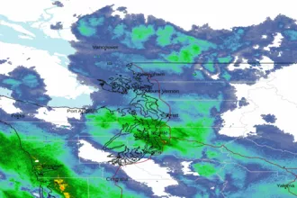 Seattle/Tacoma WA Radar
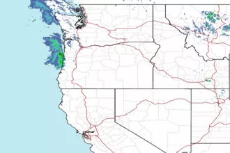 Northwest Radar