East Entrance U.S. waters Strait of Juan de Fuca Marine Forecast
| Today...W Wind 5 To 10 Kt, Rising To 10 To 15 Kt Late. Waves Around 2 Ft Or Less, Then Around 3 Ft This Afternoon. |
| Tonight...W Wind 15 To 20 Kt, Easing To 10 To 15 Kt After Midnight. Waves 3 To 4 Ft. |
| Thu...W Wind 10 To 15 Kt, Rising To 15 To 20 Kt In The Afternoon. Waves Around 2 Ft Or Less, Then Around 3 Ft In The Afternoon. A Chance Of Rain In The Morning, Then Rain Likely In The Afternoon. |
| Thu Night...W Wind 15 To 20 Kt, Becoming S 5 To 10 Kt After Midnight. Waves 3 To 4 Ft. Rain Likely In The Evening. |
| Fri...Se Wind 5 To 10 Kt, Veering To Sw In The Afternoon. Waves Around 2 Ft Or Less. |
| Fri Night...W Wind 10 To 15 Kt. Waves Around 3 Ft. |
| Sat...W Wind 5 To 10 Kt. Waves Around 3 Ft In The Morning, Then Around 2 Ft Or Less. |
| Sat Night...W Wind 5 To 10 Kt. Waves Around 2 Ft Or Less. |
| Sun...Nw Wind 5 To 10 Kt. Waves Around 2 Ft Or Less. |
| Sun Night...W Wind Around 5 Kt. Waves Around 2 Ft Or Less. |
| Area Forecast Discussion National Weather Service Seattle WA 953am PDT Wednesday July 15 2026 No changes made in this morning's update. The previous discussion remains below along with an updated aviation section. Synopsis Warm and dry conditions again today with high pressure over Western Washington. Widespread showers and the threat for thunderstorms returns Thursday as a low pressure system passes through, exiting the region this weekend. High pressure builds over the area next week, bringing a return to warm and dry weather. Short Term - Today through Friday Satellite shows some marine stratus present over the southern two- thirds of the coastline gradually seeping eastward...although its extent is still somewhat limited. The northern third of the coastline sees some stratus as well, but coverage is patchy and remains fairly stationary. Otherwise, a band of high clouds is passing over the area with some breaks here and there. Warm and dry conditions on tap again today as the upper level ridge axis begins to shift into the Great Plains. Latest models are trying to take into account some potential influence from the upper level low over the coastal waters when it comes to determining the daytime high temp for today...but any cooling would only be a degree or two different from highs yesterday. Thus, no change expected to HeatRisk over the area with most of W WA expected to remain at Minor/Yellow although some scattered areas of Moderate/Orange are expected in some valleys. The largest area of Moderate/Orange HeatRisk remains consistent with prior forecasts, generally along the I-5 corridor from the Seattle metro area down into Tacoma. Rainfall with the incoming upper low looks to be split into two waves with the first starting late tonight and primarily focused on the Cascades. The second wave enters into the CWA (County Warning Area) Thursday morning and spreads from SW to NE over the area throughout the day. This secondary wave poses the higher thunderstorm potential of the two and, unlike model output from 24 hours ago, the thunder threat no longer seems to be attached to terrain...putting the lowlands into a slight chance for thunderstorms as well. Daytime highs Thursday remain a bit of a challenge, as easterly flow during the overnight hours Wednesday could play a role in keeping temps a little higher than what would normally be the case. The timing of the changeover from offshore flow to onshore flow still looks favorable toward the cooler solutions and as such highs are expected to dip down into the lower to mid 70s for the interior lowlands, lower to mid 60s along the coast. The upper low then makes like a dine and dash, ejecting quickly out of the area Friday and taking the majority of its moisture with it. While some low-end chance to slight chance Probability of Precipitation will linger over the northern third of the CWA, generally dry conditions are expected, while daytime highs begin their rebound as mid to upper 70s are quick to return to the interior lowlands. 18 Long Term - Friday Night Through Tuesday Although upper level troughing will be present over the area Friday night and into the weekend, the building ridge over the eastern Pacific will be the driving force in W WA weather, returning warm and dry conditions to the area as this feature gradually slides eastward throughout the remainder of the forecast period. This will be most obvious in the steep warming trend in daytime highs during the long term period with temps ranging in the upper 70s to lower 80s Saturday /mid 60s to near 70 along the coast/, lower to mid 80s Sunday /lower 70s along the coast/ and upper 80s to lower 90s /mid 70s to near 80 along the coast/ on Monday. This will ratchet up HeatRisk over the area during this time frame. Saturday remains in widespread Minor/Yellow with larger swaths of Moderate/Orange becoming present for Sunday. Monday sees widespread Moderate/Orange conditions with some isolated splotches of Major/Red. The potential for a marine push Tuesday could keep this threat limited to one day as daytime highs retreat a handful of degrees. 18 Marine A weak surface low will meander over the coastal waters through Friday, resulting in northwest flow backing out of the south to southwest Thursday into Friday, before veering back out of the northwest by late Friday. Diurnal westerly flow will nonetheless continue through the Strait of Juan de Fuca, peaking each afternoon but remaining below Small Craft Advisory thresholds through at least the next few days. A more typical summertime pattern returns this weekend with northerly winds over the waters, and gusts as high as 15-25 kt beyond 30 NM. Seas of 4-6 ft today build slightly to 5-8 ft tonight into Thursday with a continued dominant west-northwest swell at 7-8 seconds. Seas ease back to 4-6 ft Friday, but stronger northwest winds developing this weekend will see 10-30% chances seas reach 8-10 ft, most likely beyond 30-40 NM. Picard Fire Weather Warm temperatures are expected to continue again today, with minimum relative humidity values dipping into the upper 20% to low 30% throughout Western Washington. An elevated fire weather pattern will set up starting tonight and likely continue through early next week. Showers and thunderstorms return to the forecast tonight through Thursday. The main concerns with these storms will be dry lightning /storms resulting in less than 0.25 of an inch of rainfall/ and the potential for strong outflows between 35-50 mph. Storms that develop on the west slopes of the Olympics are more likely to produce a wetting rain (0.25 inches or more), while storms along the Cascades will produce sub-wetting rain amounts of 0.10-0.20 inches. Taking all of that into account, the inherited Fire Weather Watch remains in place starting late tonight through Thursday evening. Fire weather concerns linger into early next week as a hotter and drier pattern sets up over Western Washington, potentially increasing fire activity from any new lightning starts from Thursday's convection. 29/18 NOAA Seattle WA Office: Watches - Warnings - Advisories WA...Fire Weather Watch from late tonight through Thursday evening for East Portion of the Olympic Mountains-West Portion of the Olympic Mountains-West Slopes of the Central Cascades Generally above 1500 Feet-West Slopes of the North Cascades Generally above 1500 Feet. PZ...None. |
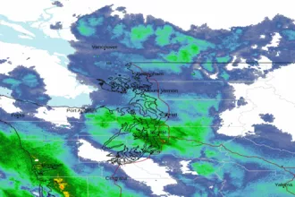 Seattle/Tacoma WA Radar
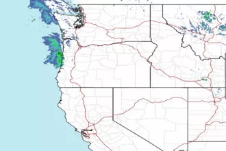 Northwest Radar