Bay Of Fundy Marine Forecast
| Winds... Wind Southwest 10 To 15 Knots Diminishing To Light Late Overnight Then Becoming Southwest 15 Near Noon Friday. |
| Waves... Seas 2 To 3 Metres Subsiding To 1 To 2 This Morning And To 1 Or Less This Afternoon. |
| Skies... Rain Ending This Evening. Showers Friday Late In The Day. Fog Patches Dissipating Near Midnight. |
| Saturday...Wind Southwest 10 To 15 Knots Increasing To Southwest 15 To 20 In The Afternoon. |
| Sunday...Wind South 25 Knots. |
| Monday...Wind South 15 Knots Increasing To Variable 15 To 20. |
Marine Weather Statement For The Maritimes
Issued By Environment Canada 2:43am ADT Thursday 7 May 2026.
A Trough Of Low Pressure Stretching From The Quebec Lower North Shore To Long Island Will Slowly Track Across The Marine District Today And Friday. Strong To Gale Force Southerly Winds Ahead Of The Trough Will Diminish In Its Wake.
Marine Interests Are Advised That Gale Warnings Are In Effect For Gulf-Magdalen - Eastern Half And Anticosti - Eastern Half.
Technical Marine Synopsis For The Maritimes
Issued By Environment Canada 3:00am ADT Thursday 7 May 2026 For Today Tonight And Friday. The Next Scheduled Synopsis Will Be Issued At 10:00am ADT.
Systems Position. At 3:00am ADT Today Trough Located From The Quebec Lower North Shore To Long Island. By 3:00am ADT Friday Trough Located From Labrador To East Scotian Slope.
At 8:00pm ADT Friday Departing Trough Located From Labrador Sea To Laurentian Fan.
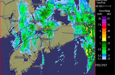
 Halifax Radar
 Atlantic Satellite