James Island to Point Grenville WA out 10 NM Marine Forecast
| Tonight...Nw Wind 20 To 25 Kt, Rising To 25 To 30 Kt Late This Evening. Seas 15 To 20 Ft, Building To 17 To 21 Ft After Midnight. Wave Detail: W 18 Ft At 15 Seconds. A Slight Chance Of Tstms This Evening. Showers. |
| Thu...W Wind 15 To 20 Kt, Easing To 10 To 15 Kt In The Afternoon. Seas 15 To 19 Ft, Subsiding To 13 To 16 Ft In The Afternoon. Wave Detail: W 15 Ft At 15 Seconds. Showers In The Morning, Then Rain Likely In The Afternoon. |
| Thu Night...Sw Wind 5 To 10 Kt, Becoming S 10 To 15 Kt After Midnight. Seas 9 To 12 Ft. Wave Detail: W 12 Ft At 15 Seconds. Rain Likely. |
| Fri...S Wind 15 To 20 Kt. Seas 7 To 9 Ft. Wave Detail: S 4 Ft At 10 Seconds And W 9 Ft At 14 Seconds. A Chance Of Rain In The Morning. |
| Fri Night...Se Wind 15 To 20 Kt. Seas 7 To 9 Ft. Wave Detail: W 9 Ft At 12 Seconds And Sw 6 Ft At 13 Seconds. A Chance Of Rain After Midnight. |
| Sat...Se Wind 20 To 25 Kt. Seas 9 To 12 Ft, Building To 11 To 13 Ft In The Afternoon. Wave Detail: Sw 7 Ft At 10 Seconds And Sw 13 Ft At 14 Seconds. Rain. |
| Sat Night...Se Wind 15 To 20 Kt. Seas 10 To 12 Ft. Wave Detail: Sw 12 Ft At 12 Seconds And Sw 12 Ft At 21 Seconds. Rain. |
| Sun...Se Wind 15 To 20 Kt. Seas 10 To 13 Ft. Wave Detail: Sw 10 Ft At 12 Seconds And W 11 Ft At 17 Seconds. Rain. |
| Sun Night...Se Wind 15 To 20 Kt. Seas 11 To 13 Ft. Wave Detail: Sw 7 Ft At 10 Seconds And W 12 Ft At 17 Seconds. Rain. |
| Mon...S Wind 10 To 15 Kt. Seas 11 To 12 Ft. Wave Detail: S 2 Ft At 11 Seconds And W 12 Ft At 15 Seconds. Rain Likely. |
| Mon Night...S Wind 5 To 10 Kt. Seas 9 To 11 Ft, Subsiding To 8 To 9 Ft After Midnight. Wave Detail: W 11 Ft At 14 Seconds. A Chance Of Rain. Winds And Seas Higher In And Near Tstms. |
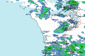
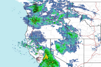
| Area Forecast Discussion National Weather Service Seattle WA 740pm PST Wednesday Jan 7 2026 Synopsis Widespread showers will continue into Tuesday. In the Cascades, this take the form of snow showers, heavy at times as snow levels will hover near 1500 feet. However, heavier showers at lower elevations may result in a rain-snow mix at times. Drier conditions are expected Friday into Saturday, with another system bringing warmer temperatures and rain to the region Sunday into Monday. Dry conditions are favored by the middle of next week. Short Term - Tonight Through Friday Night Latest radar image shows widespread showers over two-thirds of the Olympic Peninsula while activity remains more isolated on the east side of the Sound. Radar trends indicate that this might be a bit more of a splitting effect, with locations south of the Sound and north of Snohomish county at least initially receiving the bulk of activity as echoes continue eastward. Models suggest this could fill in some overnight at a weak shortwave impulse looks to keep showers in the forecast into Thursday. The main concern for heavier precip...and the prospect of mixed precipitation at lower elevations...would be the development of a convergence zone. Looking at wind obs as well as aforementioned radar trend, there is an echo currently over the southern portion of the San Juans that could be the formative stages of such a CZ...and this will warrant monitoring through the night. All in all, the forecast remains on track and inherited headlines look good. That said, no evening updates are planned at this time. For additional forecast details, please refer to the Previous Discussion section below. From Previous Discussion...As of 1230 PM, the heaviest precipitation was moving into the Cascades, with widespread shower activity in its wake across the rest of western Washington. As expected, some of the heavier showers have resulted in snow or a rain-snow mix, particularly along the Hood Canal, where some brief heavier showers led to some minor accumulations. Temperatures across the lowlands are generally in the upper 30s to around 40 so any snow will quickly melt off after individual showers end. In general, showers are expected to continue tonight into Thursday before tapering off through the day Thursday. Overnight lows tonight will fall into the low to mid-30s across the region, but most lowland locations will struggle to reach freezing, limiting accumulation potential. The main areas to watch will be some of the Olympic and Cascade foothills and valleys, particularly at elevations between 500-1500 feet where some minor accumulations are possible. In the Cascades expect snow showers to add another 8-18 inches to the already accumulated snowfall from this system by Thursday afternoon. The other primary hazard of concern will be high surf along the Pacific Coast. Waves of 20-25 feet are expected off the coast and could result in dangerous conditions for beachgoers this afternoon into Thursday. High pressure will build into the area Thursday into Friday allowing conditions to dry out and temperatures to gradually warm. Long Term - Saturday Through Wednesday Dry conditions will persist into early Saturday. The next system will likely begin to spread precipitation across the region late Saturday through roughly Monday. This will be a relatively warm system, with snow levels rising quickly from around 4000 feet to closer to 6000+ feet, limiting the snow potential. There is still a fairly wide range of potential precipitation accumulation, but even the higher end scenarios should be low enough to limit the flood potential, except perhaps the Skokomish River. In other words, expect wet PNW weather late Saturday through about Monday. Conditions should begin to dry out by the middle of next week, and longer range projections indicate a fairly strong favoring of below normal precipitation through the week 2 time frame. -Wolcott- Marine Westerly winds in the wake of the exiting front remain breezy, mainly across the coastal waters and along the Strait of Juan de Fuca into Thursday morning while winds have eased over remaining interior waters. While occasional gusts to gale will be possible along the coastal waters and along the Strait tonight, expect the majority of the winds to remain between 20-30 kt. In addition to winds, expect seas across the coastal waters to build towards 20-25 ft tonight. Seas will then peak late tonight into early Thursday. Winds will ease and seas will gradually subside through the day Thursday as high pressure builds back over the area. High pressure will then remain situated over the area through Friday, with seas decreasing towards 8-10 ft. A weak frontal system looks to move across the area on Saturday, bringing the next round of breezy southerlies to the waters. Seas will build towards 13-16 ft in response, before subsiding again on Sunday. A warm front may clip the coastal waters on Sunday for another round of breezy southerly winds, but expect impacts to remain minimal at this time. High pressure will then build back over the area waters early next week. 14/18 Hydrology The Skokomish River in Mason County continues to fluctuate within action stage this afternoon, but is not expected to reach flood stage given the relatively low snow levels and decreasing precipitation. Drier conditions expected Friday and Saturday will allow for decreasing river levels. Another, potentially wet system is expected Sunday-Monday. There is still a fairly wide range out potential outcomes, but the vast majority of solutions would keep rivers out of flood stage. The one exception to monitor will be the Skokomish. Dry conditions are expected by the middle of next week which are favored to persist well into the week-2 time frame. -Wolcott- NOAA Seattle WA Office: Watches - Warnings - Advisories WA...Winter Storm Warning until 4pm PST Thursday for Cascades of Pierce and Lewis Counties-Cascades of Snohomish and Northern King Counties-Cascades of Southern King County- Cascades of Whatcom and Skagit Counties. High Surf Advisory until 10am PST Thursday for Grays Harbor County Coast-Northern Washington Coast. PZ...Small Craft Advisory until 4am PST Friday for Grays Harbor Bar Small Craft Advisory until 10am PST Friday for Coastal Waters From Cape Flattery To James Island 10 To 60 Nm- Coastal Waters From Cape Flattery To James Island Out 10 Nm- Coastal Waters From James Island To Point Grenville 10 To 60 Nm- Coastal Waters From James Island To Point Grenville Out 10 Nm- Coastal Waters From Point Grenville To Cape Shoalwater 10 To 60 Nm- Coastal Waters From Point Grenville To Cape Shoalwater Out 10 Nm- West Entrance USA Waters Strait Of Juan De Fuca. Small Craft Advisory until 7am PST Thursday for Central U.S. Waters Strait Of Juan De Fuca- East Entrance U.S. Waters Strait Of Juan De Fuca. |