South Shore Bays from Jones Inlet through Shinnecock Bay Marine Forecast
| Today...Nw Winds 5 To 10 Kt. Waves 1 Ft Or Less. Slight Chance Of Showers Early. |
| Tonight...Nw Winds 5 To 10 Kt, Becoming Sw After Midnight. Waves 1 Ft Or Less, Then Around 2 Ft After Midnight. |
| Sat...Sw Winds 5 To 10 Kt, Increasing To 10 To 15 Kt With Gusts Up To 20 Kt In The Afternoon. Waves 1 Ft Or Less. |
| Sat Night...Sw Winds 15 To 20 Kt With Gusts Up To 25 Kt. Waves 1 Ft Or Less. |
| Sun...Sw Winds 5 To 10 Kt. Waves 1 Ft Or Less. |
| Sun Night...Sw Winds 5 To 10 Kt, Becoming Ne After Midnight. Waves 1 Ft Or Less. |
| Mon...Se Winds 5 To 10 Kt. Waves 1 Ft Or Less. |
| Mon Night...S Winds Around 5 Kt. Waves 1 Ft Or Less. |
| Tue...Sw Winds 10 To 15 Kt With Gusts Up To 25 Kt. Waves 1 Ft Or Less. |
| Tue Night...Sw Winds 10 To 15 Kt With Gusts Up To 25 Kt. Waves 1 Ft Or Less. |
| Area Forecast Discussion National Weather Service New York NY 724am EDT Fri May 15 2026 .WHAT HAS CHANGED... No significant changes made. .KEY MESSAGES... 1) Upper low departs to the east today with isolated to widely scattered showers. 2) Summer-like warmth builds this weekend into the first half of of next week. Cold water safety concerns for this weekend with good boating weather, and water temps still in the lower 50s. .KEY MESSAGE 1... An upper low over the area this morning will pass to the east today with isolated to widely scattered showers. The best chance will be this afternoon across southern CT and eastern LI. Steep low-level lapse rates, cyclonic flow, and low-level moisture should also result in a fair amount of clouds, with partly to mostly cloudy skies. W-NW winds may gust 15 to 20 mph. Highs today are forecast to get up into the 60s, slightly below normal for most locations. .KEY MESSAGE 2... Upper level ridging builds in tonight through early Saturday, then flattens some for the rest of the weekend before significant height rises work into the easter third of the country early next week. The latter of which will result in a significant warmup, with highs 15 to 20 degrees above normal for Tuesday and Wednesday. At this time, forecast highs fall well short of record highs, with many well into the 90s. Before then though, temperatures will steadily increase through the weekend, with highs in the 70s to lower 80s Saturday, then into the 80s for most locations on Sunday. Highs could get close to 90 across metro NE NJ. BDR and ISP are forecast to be a few degrees short of record highs Sunday, which is 85 set back in 1974. The high temperature forecast remains a bit tricky as the NBM5.0 continues to look too warm, especially near the coast. Have generally adjusted it downward for high temps a couple of degrees Saturday and Sunday. Much of the guidance is still a bit cooler than these values as well. What is interesting, is the NBM box and whisker plots show very small differences over the weekend between the 25th and 75th percentiles. The median and NBM deterministic are nearly on top of each other. So this tells us there is not much spread in the guidance, however, the bias algorithms may be still adjusting heading into the warm season. Time will tell. Additionally, there are cold water safety concerns this weekend as water temperatures remain in the lower 50s. The cold water temperatures can quickly cause hypothermia and physical incapacitation to anyone suddenly immersed in the water. Anyone going out on small boats, canoes or kayaks should plan accordingly and use extreme caution to avoid this threat. A Marine Weather Statement will likely be issued later today. Global model guidance for midweek continues to show a break down of the upper-level ridge in response to a closed upper-low traversing Canada. Rain chances increase with a cool down for the end of the week. Marine A building SE swell from low pressure heading up into the Canadian Maritime will produce SCA (Small Craft Advisory) seas across the ocean waters today into the fist half of tonight. Any respite after this will be short-lived, as high pressure quickly builds across the waters late tonight into Saturday morning, then to the east. A strengthening southerly flow is likely to bring a return to SCA (Small Craft Advisory) conditions on the ocean late Saturday afternoon/early evening. Some of the south shore bays could eve see a period of 25 kt gusts. Winds and seas will then begin to gradually subside the second half of Saturday night into Sunday. However, seas could linger around 5 ft on the ocean waters for much of Sunday. Sub-SCA (Small Craft Advisory) conditions are anticipated Sunday night through Monday night. Tuesday into Tuesday night, seas on ocean waters may climb to 5 ft. There are cold water safety concerns this weekend as water temperatures remain in the lower 50s. The cold water temperatures can quickly cause hypothermia and physical incapacitation to anyone suddenly immersed in the water. Anyone going out on small boats, canoes or kayaks should plan accordingly and use extreme caution to avoid this threat. A Marine Weather Statement will likely be issued later today. NOAA New York NY Office: Watches - Warnings - Advisories CT...None. NY...None. NJ...None. Marine Small Craft Advisory until 6am EDT Saturday for ANZ350. Small Craft Advisory until 6am EDT Saturday for ANZ353. Small Craft Advisory from 11am this morning to 6am EDT Saturday for ANZ355. |
 New York Radar
 Northeast Radar
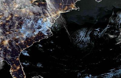
 East Coast Satellite