Cascade Head to Florence OR from 10 to 60 NM Marine Forecast
| Rest Of Today...S Wind To 5 Kt. Wind Waves S 1 Ft At 4 Seconds. Nw Swell 3 Ft At 9 Seconds. Widespread Dense Fog In The Morning. Areas Of Dense Fog In The Afternoon. |
| Tonight...N Wind To 5 Kt. Wind Waves N 1 Ft At 4 Seconds. Nw Swell 3 Ft At 9 Seconds. Areas Of Dense Fog In The Evening. Patchy Dense Fog After Midnight. |
| Wed...Ne Wind 5 Kt, Backing To Nw To 5 Kt In The Afternoon. Wind Waves Ne 1 Ft At 4 Seconds, Shifting To The Nw At 4 Seconds In The Afternoon. Nw Swell 3 Ft At 9 Seconds. Patchy Dense Fog In The Morning. |
| Wed Night...Nw Wind 5 Kt, Backing To Se After Midnight. Wind Waves Nw 1 Ft At 4 Seconds, Shifting To The Se At 4 Seconds After Midnight. Nw Swell 3 Ft At 9 Seconds. |
| Thu...S Wind 5 Kt. Wind Waves S 1 Ft At 4 Seconds. Nw Swell 3 Ft At 10 Seconds. |
| Thu Night...N Wind 5 To 10 Kt. Wind Waves N 2 Ft At 4 Seconds. Nw Swell 3 Ft At 10 Seconds. |
| Fri...N Wind 5 To 10 Kt. Wind Waves 2 Ft. Nw Swell 4 Ft. |
| Sat...Nw Wind 5 To 10 Kt. Wind Waves 2 Ft. Nw Swell 4 Ft. |
| Area Forecast Discussion National Weather Service Portland OR 334am PDT Monday April 29 2024 Synopsis Relatively colder weather systems will move through northwest Oregon and southwest Washington today and tomorrow. Expect lowland rain showers, Cascade snow showers, and the potential for thunderstorms with these systems. Potential hazards with any thunderstorms or heavy showers include lightning, small hail, heavy rain, and gusty winds. Conditions become dry and warm up on Wednesday. Another system arrives on Thursday, with unsettled weather potentially continuing into the weekend. .SHORT TERM...Now through Wednesday...As of 3am PDT, an upper level trough is beginning to enter the Pacific Northwest. The associated surface cold front is now moving inland, with radar imagery showing increasing shower activity across northwest Oregon and southwest Washington. Expect a continuation of lowland rain showers and Cascade snow showers as the system pushes through today. Snow levels will gradually fall this morning and settle between 2500-3500 ft today. Thus, the Winter Weather Advisory remains in effect for our entire Cascades through this afternoon, with the heaviest snowfall expected above the passes. Forecast Quantitative Precipitation Forecast today will be around 0.15-0.40 inch for the coast and inland valleys. Expect an additional 2-8 inches of snow in the Cascades, except up to 12 inches above the passes. Note that there will be a 15-25% chance of thunderstorms across northwest Oregon and southwest Washington today. Potential hazards with any thunderstorms or heavy showers include lightning, small hail, heavy rain, and gusty winds. Cold air will filter in aloft as the upper trough progresses through the region between now and 11am - 1pm today. This will create a more unstable airmass, as HREF shows CAPE values increasing to around 150-300 J/kg today. The threat for small hail will also increase as models show 500 mb temperatures falling to -30 to -35 deg C and lapse rates steepening to around -8 deg C/km. The upper trough doesn't dip too far south, so locations north of Lincoln City/Salem have the highest probabilities (20-25%) for thunderstorms today. The upper level trough is expected to exit our area and push east of the Cascades after 1-3pm today. Expect mostly light and decreasing shower activity late afternoon through this evening. However, the Cascades could maintain a 15-20% chance of thunderstorms this evening as the system exits. This relative lull will be short-lived: another low pressure system will drop down from the northwest tonight into Tuesday. This low is forecast to make landfall over the north Oregon coast. Similar to today, we'll also have a 15-25% chance for thunderstorms across the region. Forecast Quantitative Precipitation Forecast will be around 0.25-0.50 along the coast and inland valleys. Meanwhile, the Cascades would see another round of snowfall, albeit it doesn't look advisory worthy at the moment. Snow levels fall to around 2000 ft tonight, with an additional 2 to 6 inches of snow for the Cascades in a 24 hour period ending at 11pm Tuesday. With these cooler systems in place today and tomorrow, high temperatures will be around 10 degrees below normal. Expect today and tomorrow's highs to be in the low to mid 50s along the coast and inland valleys, 40s in the Coast Range and Willapa Hills, and 30s in the Cascades (sub-freezing highs for the crest and highest peaks of the Cascades). Tuesday night to Wednesday, conditions begin to dry up as the second system pushes east and upper level high pressure builds. We could see some clearing Tuesday night - this could lead to radiational cooling and the potential for frost development. Currently, it looks like the highest frost potential will be in the Coast Range, Willapa Hills, and Upper Hood River Valley. Based on the latest NBM, these locations of a greater than 70-90% chance of Wednesday morning lows dropping below 37 degrees. For the Willamette Valley, that probability is around 40-60%. Seasonable high temperatures will likely return Wednesday, with a 60-80% chance of highs exceeding 60 degrees for inland valleys. -Alviz Long Term Thursday through next Sunday...WPC cluster analyses have around 65% of ensemble members suggesting an additional trough pushing into the Pacific Northwest Thursday. In this case, we would see another round of light precipitation. The other 35% of ensembles members suggest ridging, which would maintain drier conditions. Current NBM probabilities for Quantitative Precipitation Forecast exceeding 0.25 inch ending 5pm Thursday is less than 20% for inland valleys and 40-50% for the Coast Range and Cascades. Friday looks relatively drier as the majority of WPC clusters suggest transient ridging; however, the ridging doesn't look particularly strong. This may allow for some shortwave troughing to push through and bring some precipitation. The majority of clusters still show precipitation on Friday, despite them also showing ridging. With this uncertainty, NBM Probability of Precipitation of 25-50% across the region Friday look reasonable. Saturday to Sunday, the majority of the clusters are showing a troughing pattern returning. However there is uncertainty with the strength of the next trough. About half of the ensemble members show weak troughing moving into the Pacific Northwest, while the other half show a deeper trough developing over the NE Pacific. The members that show the deeper trough have it progressing southward toward southern Oregon and northern California by Sunday, and becoming negatively tilted. In either scenario, unsettled weather with showery activity would continue for our area. -Alviz Marine Active weather continues into midweek. A surface front moving through the waters on Monday will bring another round of elevated winds along with steep and choppy seas through at least Monday afternoon. Generally westerly winds with gusts up to 25 kt and seas of 6 to 9 ft at 10 to 13 seconds through this time frame. Therefore have maintained the current suite of Small Craft Advisories. A series of weak fronts will move through the waters Monday night into Tuesday and again late Tuesday into Wednesday, bringing elevated winds and seas at times. Some models are suggesting that small craft conditions could develop with each frontal passage. Will continue to monitor the situation as it develops. -HEC/42 NOAA Portland OR Office: Watches - Warnings - Advisories OR...Winter Weather Advisory until 3pm PDT this afternoon for ORZ126>128. WA...Winter Weather Advisory until 3pm PDT this afternoon for WAZ211. PZ...Small Craft Advisory until 11pm PDT Tuesday for PZZ210-251>253- 271>273. |
 Portland OR Radar
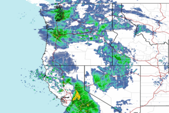 Northwest Radar