Oregon Inlet to Cape Hatteras, NC out 20 NM Marine Forecast
| Today...Sw Winds 10 To 15 Kt With Gusts Up To 25 Kt. Seas 3 To 4 Ft. Wave Detail: E 3 Ft At 10 Seconds And Sw 3 Ft At 4 Seconds. |
| Tonight...Sw Winds 15 To 20 Kt With Gusts Up To 25 Kt, Diminishing To 10 To 15 Kt After Midnight. Seas 3 To 4 Ft. Wave Detail: E 3 Ft At 11 Seconds And S 3 Ft At 4 Seconds. |
| Tue...Sw Winds 10 To 15 Kt. Seas 3 To 4 Ft. Wave Detail: Ne 3 Ft At 12 Seconds And S 3 Ft At 4 Seconds. |
| Tue Night...Sw Winds 10 To 15 Kt. Seas 4 To 5 Ft. Wave Detail: Ne 3 Ft At 12 Seconds And S 3 Ft At 4 Seconds. |
| Wed...Sw Winds 10 To 15 Kt. Seas 3 To 4 Ft. Wave Detail: S 3 Ft At 5 Seconds And Ne 2 Ft At 11 Seconds. A Chance Of Showers. A Chance Of Tstms In The Afternoon. |
| Wed Night...Sw Winds 5 To 10 Kt, Becoming W After Midnight. Seas 2 To 3 Ft. Wave Detail: Ne 2 Ft At 10 Seconds And S 2 Ft At 5 Seconds. A Chance Of Showers And Tstms In The Evening. |
| Thu...N Winds 5 To 10 Kt. Seas 2 To 3 Ft. |
| Thu Night...Ne Winds 5 To 10 Kt. Seas 2 To 3 Ft. |
| Fri...E Winds 5 To 10 Kt. Seas 2 To 3 Ft. |
| Fri Night...Se Winds 5 To 10 Kt. Seas 2 To 3 Ft. Winds And Seas Higher In And Near Tstms. |
| Area Forecast Discussion National Weather Service Newport/Morehead City NC 406am EDT Monday April 29 2024 Synopsis High pressure will remain anchored offshore through mid week. A cold front will impact the area late in the week. Near Term - Until 6pm This Evening As of 230am Monday... Given how active this time of year could be, the weather is expected to be remarkably quiet today thanks to mid/upper level ridging overhead. At the surface, high pressure has slid further south which will keep more of a southwesterly low-level flow going. This combined with warming low-level thicknesses will support above to well above normal highs away from the coast. Short Term - 6pm This Evening Through 6am Tuesday As of 230am Monday... Mid/upper level ridging remains overhead tonight, with a continued southwesterly flow helping support mild, above normal, overnight temperatures. One potential fly in the ointment for tonight is the potential development of fog/stratus. The orientation of the high offshore will support a moistening southwesterly flow, with dewpoints forecast to rise into the low 60s through the night. Forecast soundings suggest the depth of low-level moistening may be sufficiently deep to support some low stratus, or fog, development. At minimum, it could be a scenario where at least patchy fog is able to develop that has more depth to it than the patchy ground fog of late. Long Term - Tuesday Through Sunday As of 330am Monday... KEY MESSAGES - Low to mid 80s for the rest of the week - Best rain chances Wednesday and then this weekend FORECAST DETAILS Above normal temperatures persist on Tuesday with highs in the low to mid 80s inland and mid to upper 70s along the coast. A mid-level trough will amplify as it moves east across the SECONUS. Dry weather should prevail Tuesday with the system not making its way to ENC until Wednesday. With this disturbance expected to pass during Wednesday's peak heating, showers and thunderstorms are possible across the area (30-55% chance). Although thunderstorms are possible, severe storms are less likely as very little shear is expected. Thursday has trended drier for showers and thunderstorms with PoPs below slight chance. Temperatures will remain high with the upper 80s inland to mid to upper 70s along the coast. A little more moisture advection Saturday and Sunday with both the Bermuda High and an approaching frontal system from the west contributing to the increase in precipitable water. Increasing chances for rain and thunderstorms (35-40%) by Saturday afternoon and then lingering into Sunday as the front moves into the region. Temperatures slightly cooler both days but still well above normal for this time of year. Marine SHORT TERM Through Tonight As of 230am Monday... Relatively good boating conditions are expected through tonight. However, there are a couple of caveats worth mentioning. The diurnal increase in southwesterly winds associated with the developing thermal gradient may support a few gusts to 25kt for the coastal waters and the Pamlico Sound. The duration and magnitude forecast appears too marginal for any marine headlines, and I'll continue to hold off on this for now. For the coastal waters, seas are forecast to hold in the 2-4 ft range through this evening. By tonight, long period swell arriving from the Northern Atlantic may lead to seas building to 3-5 ft, especially north of Cape Hatteras. Long Term - Tuesday Through Friday As of 330pm Sunday... KEY MESSAGES - Good boating conditions expected early this week FORECAST DETAILS High pressure will shift offshore early this week, with inland troughing developing in the lee of the Appalachians. Winds will steadily increase early next week with southwesterly flow of 10-20kt common. Seas of 3-5 ft will be common through early next week, setting up good boating conditions for several days. NOAA Newport/Morehead City NC Office - Watches - Warnings - Advisories NC...None. Marine None. |
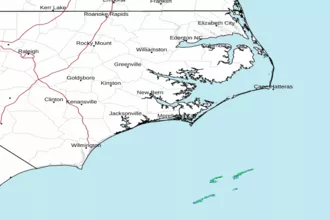 Newport NC Radar
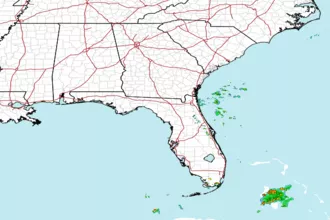 Southeast Radar
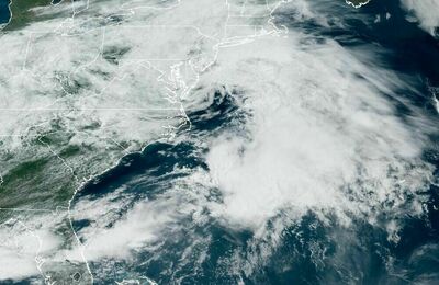 East Coast Satellite