Casco Bay Marine Forecast
| Today...Ne Winds Around 5 Kt, Becoming Se Around 5 Kt This Afternoon. Seas Around 2 Ft This Morning, Then 1 Foot Or Less. |
| Tonight...Sw Winds Around 5 Kt, Becoming N After Midnight. Seas 1 Foot Or Less. |
| Mon...Ne Winds Around 5 Kt, Becoming Se In The Afternoon. Seas 1 Foot Or Less. |
| Mon Night...E Winds Around 5 Kt. Seas 1 Foot Or Less. |
| Tue...Ne Winds Around 5 Kt, Becoming E In The Afternoon. Seas Around 2 Ft. |
| Tue Night...E Winds 5 To 10 Kt. Seas 2 To 3 Ft. |
| Wed...E Winds 5 To 10 Kt. Seas 3 To 5 Ft. |
| Wed Night...E Winds 5 To 10 Kt. Seas 3 To 5 Ft. Showers Likely. |
| Thu...E Winds 10 To 15 Kt With Gusts Up To 20 Kt. Seas 3 To 5 Ft. Showers. |
| Thu Night...E Winds 10 To 15 Kt With Gusts Up To 25 Kt. Seas 3 To 5 Ft. Showers. |
| Area Forecast Discussion National Weather Service Gray ME 624am EDT Sunday April 26 2026 .WHAT HAS CHANGED... Minor update toNear Term - Rest Of Today Through Tonight s to align with observed trends .KEY MESSAGES... 1. Dry weather continues through the Tuesday with near seasonable temperatures. 2. Wet weather makes a return for the second half of the week. KEY MESSAGE 1 DESCRIPTION... No high impact weather is expected through Tuesday as high pressure ridging continues to hold firm across New England. With the high pressure system nearby or just to the east we can expect onshore flow much of the time which will keep temperatures from getting too warm, especially at the coast. Dry weather continues as well. KEY MESSAGE 2 DESCRIPTION... Wednesday kicks off a pattern change to rainy conditions, but precipitation chances peak Thursday and Friday, where a soaking rain looks increasingly likely. Wednesday shows scattered (20-40%) rain chances as some remnant energy with the offshore coastal low may phase with the incoming shortwave from the Great Lakes. By Thursday, precipitation chances are widespread (80-100%) as the main trough axis moves in. Some newer guidance is suggesting a dual low pressure structure, with a second low forming near the New England coast as the first low cuts north into Quebec. This may lead to locally enhanced precipitation totals in our vicinity. By Friday, model spread becomes evident, as some guidance members suggest a more progressive system with improving conditions, but others show the second low cutting off over New England, leading to continued rainy conditions into the weekend (although it is unlikely to be raining the entire time). How much precipitation is on the way? NBM has a widespread 1-2 inches across the entire forecast area, specifically for the ensemble mean from Wednesday-Friday, and some eye-popping values for the 90th percentile (2-4 inches). Keep in mind this is representing a three day rainfall. Therefore, right now we are not concerned about excessive rainfall, but regardless there is the potential for a soaking rainfall which could help make a much needed dent in the current drought conditions. Finally, with cooling temperatures aloft, there is the chance for some mountain snow. Marine Sub-sca conditions are expected through Tuesday as high pressure builds over the waters. SCA (Small Craft Advisory) conditions likely Tuesday night through at least Thursday due to building seas outside of the bays as low pressure crosses over the Gulf of ME. Gale conditions possible for the outer waters Thursday-Friday with gusts up to 40 kts. NOAA Gray/Portland ME Office - Watches - Warnings - Advisories ME...None. NH...None. Marine None. |
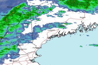 Portland ME Radar
 Northeast Radar