Cape Lookout to Surf City, NC out 20 NM Marine Forecast
| Tonight...Ne Winds 15 To 20 Kt With Gusts To 25 Kt Early, Becoming E. Seas 3 To 5 Ft, Except 2 To 3 Ft Near Shore. Wave Detail: E 4 Ft At 5 Seconds And Ne 1 Ft At 9 Seconds. Adjacent Sounds And Rivers Choppy. |
| Sat...E Winds Around 15 Kt. Seas 3 To 5 Ft, Except 2 To 3 Ft Near Shore. Wave Detail: E 4 Ft At 6 Seconds. Adjacent Sounds And Rivers A Moderate Chop. |
| Sat Night...E Winds 5 To 10 Kt. Seas 2 To 4 Ft. Wave Detail: E 3 Ft At 7 Seconds. Adjacent Sounds And Rivers Light Chop. |
| Sun...Se Winds 5 To 10 Kt, Becoming S In The Afternoon. Seas 2 To 3 Ft. Wave Detail: Se 3 Ft At 7 Seconds. Adjacent Sounds And Rivers Light Chop. |
| Sun Night...Sw Winds 10 To 15 Kt. Seas 2 To 4 Ft. Wave Detail: Se 3 Ft At 8 Seconds. Adjacent Sounds And Rivers A Moderate Chop. |
| Mon...Sw Winds 10 To 15 Kt. Seas 2 To 4 Ft. Wave Detail: E 2 Ft At 10 Seconds And Se 2 Ft At 7 Seconds. Adjacent Sounds And Rivers A Moderate Chop. |
| Mon Night...Sw Winds 10 To 15 Kt. Seas 2 To 4 Ft. Adjacent Sounds And Rivers A Moderate Chop. |
| Tue...Sw Winds 10 To 15 Kt. Seas 2 To 3 Ft. Adjacent Sounds And Rivers A Moderate Chop. |
| Tue Night...Sw Winds Around 15 Kt. Seas 3 To 4 Ft. Adjacent Sounds And Rivers A Moderate Chop. |
| Wed...Sw Winds 10 To 15 Kt. Seas 2 To 4 Ft. Adjacent Sounds And Rivers A Moderate Chop. |
| Wed Night...Sw Winds 10 To 15 Kt. Seas 2 To 3 Ft. Adjacent Sounds And Rivers A Moderate Chop. |
| Area Forecast Discussion National Weather Service Newport/Morehead City NC 218pm EDT Fri April 26 2024 Synopsis High pressure will remain in control while gradually sliding offshore this weekend into early next week. A few upper disturbances will bring better chances for precipitation late next week. Near Term - Through Tonight As of 220pm Fri...Latest analysis shows strong 1033mb high pressure centered over the NE US, ridging southwestward into the Carolinas. Quiet weather continues tonight as high pressure slowly move southeastward. Lows falling into the upper 40s and low 50s across the area. Short Term - Saturday As of 220pm Fri...Upper ridge will continue to build over the SE US as strong high pressure becomes centered along the Mid- Atlantic coast. This should lead to another pleasant, dry spring day with temps a few degrees below normal thanks to low level easterly flow. Highs ranging from the 60s along the Outer Banks to low to mid 70s inland. Long Term - Saturday Night Through Friday As of 300am Friday... KEY MESSAGES - Well above normal temperatures Tuesday-Thursday - Thunderstorm risk may return mid to late-week FORECAST DETAILS The most prominent feature in the long-term period will be an amplified upper level ridge forecast to develop over the Eastern U.S. this weekend and into early next week. Beneath the ridge, warm/above normal low-level thicknesses are forecast to develop. There may be some mid-level cloudiness around over the weekend, but by early next week, the combination of mostly sunny skies, warm thicknesses, a reduced risk of precipitation, and persistent southwesterly flow should support a period of well above normal temperatures focused in the Tuesday-Thursday timeframe. Both deterministic and ensemble guidance support this, and with this forecast update, I've bumped temps up towards the 75th percentile of guidance. Inland, this suggests highs in the upper 80s to near 90. Along the coast, this suggests mid to upper 70s to near 80 degrees. With persistent southerly flow, dewpoints are forecast to steadily increase early next week as well, which may allow heat indices to reach the 90s. While not headline-worthy, it's still noteworthy as this would increase the risk of heat exhaustion for those with prolonged exposure. From mid to late-week, model guidance begins to differ, but the general theme is for the ridge to breakdown. While not immediate, the lack of ridging could eventually open the door to an increase in the risk of convection, if for no other reason than the daily seabreeze. Several shortwaves are forecast to pass over, or near, the Carolinas late in the week, which would also support an increase in the risk of convection. Of note, CIPS and CSU severe weather guidance are showing a modest signal for severe weather potential late-week, although deterministic guidance show less of a signal. Despite the differences, it's something to watch as we move into next week. Forecast-wise, we'll show a low-end risk of thunderstorms Thursday into Friday (10-30% chance). While still warm, temperatures late in the week should lower some compared to early in the week, especially with the potential for thunderstorms and more cloudiness around at times. Marine SHORT TERM /through Saturday/... As of 220pm Fri...Latest obs show NE winds 10-20 kt gusting 20-25 kt, with seas 4-6 ft north of Ocracoke and 3-5 ft south. SCAs (Small Craft Advisories) will continue into early this evening for the southern waters and the Pamlico Sound, and through late tonight into Saturday for the northern and central waters. Winds will gradient veer and slowly diminish to 10-15 kt overnight. Though elevated seas will linger north of Ocracoke. Strong high pressure becomes centered along the Mid-Atlantic coast Saturday, with winds becoming more easterly. E winds 10-15 kt with occasional gusts to 20 kt early. Seas will continue to gradient diminish to 3-6 ft, potentially lingering at 6 ft across the outer central waters through late afternoon. Long Term - Saturday night Wednesday: As of 200am Friday... KEY MESSAGES - Good boating conditions expected late-weekend into early next week FORECAST DETAILS High pressure overhead this weekend will shift offshore early next week, with inland troughing developing in the lee of the Appalachians. Winds will be very light over the weekend, then will steadily increase early next week with southwesterly flow of 10-20kt common. Seas of 3-5 ft will be common through early next week, setting up good boating conditions for several days. The one exception is early this weekend as seas will remain elevated within the northeasterly background swell that has been impacting the area for the past few days. NOAA Newport/Morehead City NC Office - Watches - Warnings - Advisories NC...Beach Hazards Statement until 8pm EDT this evening for NCZ203- 205. Marine Small Craft Advisory until 7pm EDT this evening for AMZ135(Pamlico Sound)- 156-158. Small Craft Advisory until 7am EDT Saturday for AMZ150. Small Craft Advisory until 2pm EDT Saturday for AMZ152(Oregon Inlet to Cape Hatteras NC)-154. |
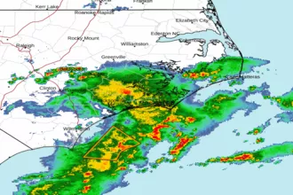 Newport NC Radar
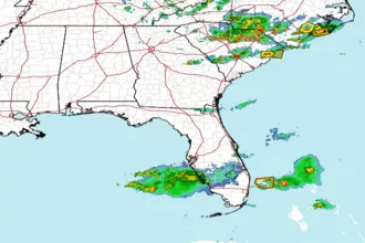 Southeast Radar
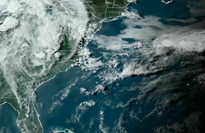 East Coast Satellite