Neah Bay, WA Weather Forecast
Marine Forecast: Strait of Juan de Fuca - West Entrance US Waters
Neah Bay, Washington
Lat: 48.37N, Lon: 124.62W
Overcast
Temp: 54°F
- Humidity:
- 69%
- Winds:
- 5 MPH VRB
- Gusts:
- N/A MPH
- Barometer:
- 30.37 in.
- Dewpoint:
- 44°F
- Heat index:
- 54°F
- Sunrise:
- 5:43 AM PDT
- Sunset:
- 9:03 PM PDT
- Moonrise:
- 7:06 PM PDT
- Moonset:
- 1:36 AM PDT
| Today...Cloudy with a chance of rain in the morning, then rain at Times in the afternoon. Rainfall amounts a tenth to a quarter of an inch possible. Highs in the 40s. East wind 10 to 20 mph. Gusts to 30 mph. |
| Tonight...Rain until early morning, then mostly cloudy with a chance of rain in the morning. Rainfall amounts a half inch to one inch possible. Lows near 40. Southeast wind 10 to 20 mph becoming southwest 10 to 15 mph after midnight. Gusts to 35 mph. |
| Thursday...Rain at Times. Rainfall amounts a quarter to a half inch possible. Highs in the 40s. South wind 10 to 15 mph with gusts to 30 mph. |
| Thursday Night...Rain. Rainfall amounts a half inch to one inch possible. Lows near 40. South wind 10 to 15 mph becoming southwest after midnight. Gusts to 35 mph. |
| Friday...Rain. Rainfall amounts a quarter to a half inch possible. Highs in the 40s. Southwest wind 10 to 15 mph with gusts to 25 mph. |
| Friday Night...Rain showers in the evening, then rain showers likely after midnight. Lows in the mid to upper 30s. |
| Saturday...Rain showers likely in the morning, then rain at Times in the afternoon. Highs in the mid to upper 40s. |
| Saturday Night...Rain at Times. Lows in the lower 40s. |
| Sunday...Rain at Times. Highs in the upper 40s. |
| Sunday Night...Rain at Times. Lows in the mid 40s. |
| Monday...Rain at Times. Highs in the lower to mid 50s. |
| Monday Night...Mostly cloudy with rain likely in the evening, then mostly cloudy with a chance of rain after midnight. Lows in the mid to upper 40s. |
| Tuesday...Partly sunny. A chance of rain in the morning, then a slight chance of rain in the afternoon. Highs in the upper 50s. && temperature / precipitation sekiu 45 42 46 / 100 100 100 |
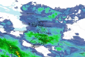 Seattle/Tacoma WA Radar
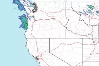 Northwest Radar