Cape Flattery to James Island WA out 10 to 60 NM Marine Forecast
| Rest Of Today...Nw Wind 20 To 25 Kt. Seas 9 To 12 Ft. Wave Detail: Nw 12 Ft At 10 Seconds. |
| Tonight...Nw Wind 20 To 25 Kt. Seas 9 To 12 Ft. Wave Detail: Nw 12 Ft At 10 Seconds. |
| Wed...Nw Wind 15 To 20 Kt, Becoming W 10 To 15 Kt In The Afternoon. Seas 7 To 9 Ft, Subsiding To 5 To 7 Ft In The Afternoon. Wave Detail: Nw 9 Ft At 9 Seconds. |
| Wed Night...W Wind 10 To 15 Kt, Easing To 5 To 10 Kt After Midnight. Seas 4 To 5 Ft. Wave Detail: Nw 5 Ft At 7 Seconds And Sw 2 Ft At 17 Seconds. |
| Thu...S Wind 5 To 10 Kt. Seas Around 4 Ft. Wave Detail: W 4 Ft At 8 Seconds And Sw 2 Ft At 17 Seconds. A Chance Of Showers In The Morning, Then Showers Likely In The Afternoon. |
| Thu Night...S Wind 5 To 10 Kt, Veering To Sw After Midnight. Seas 4 To 5 Ft. Wave Detail: W 3 Ft At 8 Seconds And Sw 2 Ft At 17 Seconds. A Chance Of Showers. |
| Fri...W Wind Around 5 Kt. Seas Around 4 Ft. Wave Detail: W 4 Ft At 8 Seconds And Sw 2 Ft At 16 Seconds. |
| Fri Night...W Wind 5 To 10 Kt. Seas Around 4 Ft. Wave Detail: W 4 Ft At 9 Seconds And Sw 2 Ft At 15 Seconds. |
| Sat...W Wind 5 To 10 Kt. Seas Around 4 Ft. Wave Detail: W 4 Ft At 9 Seconds And Sw 2 Ft At 16 Seconds. |
| Sat Night...Nw Wind 10 To 15 Kt. Seas 4 To 6 Ft. Wave Detail: Nw 6 Ft At 8 Seconds And Sw 2 Ft At 16 Seconds. |
| Area Forecast Discussion National Weather Service Seattle WA 829am PDT Tuesday Jun 30 2026 Synopsis A broad upper level trough will continue to produce mostly cloudy and cool conditions across Western Washington into Thursday along with chances for mainly mountain showers. Drier conditions and a small warming trend are expected Friday into the holiday weekend as the flow aloft becomes first more zonal then southwesterly by Monday. Short Term - Today through Thursday No changes to the forecast this morning. Thick marine stratus (depths around 3000 ft) will continue to persist across the area for most of the day, slowly lifting and breaking up by the afternoon for some sun breaks by the late afternoon/early evening. Temperatures currently in the mid 50s are on track to reach the mid 60s for highs. 62 Little change in the pattern for the next three days. Weak upper level trough over the area with onshore flow through Thursday. The onshore flow will keep plenty of low level moisture over the area resulting in cloudy mornings with slight clearing in the afternoon. Could see a light shower or a little drizzle in the lowlands during the morning commute along with a light late day shower in the mountains. Temperatures will remain well below normal with highs in the upper 50s to mid 60s. Lows in the upper 40s to mid 50s. Long Term - Thursday Night Through Monday Weakening front fizzles out as it moves into the area Thursday night. Weak trough overhead gets replaced by zonal flow aloft beginning Friday with the zonal flow aloft continuing into Sunday. 500 mb heigheights rising over the weekend into the mid to upper 570s dms. Low level flow remaining onshore which will keep temperatures from warming too much. Warmer Friday with highs in the mid 60s to mid 70s. Temperatures remaining in that range over the weekend. A little more warming Monday as an upper level trough digs well offshore turning the flow aloft southwesterly. Highs Monday in the 70s over the interior with the warmer locations pushing 80. Highs on the coast with the continued Marine Broad high pressure will continue over the northeast Pacific with lower pressure inland. High pressure will weaken Thursday as a low moves towards the British Columbia coast with a weak front over the coastal waters. High pressure will rebuild later Friday into the weekend. Diurnal westerly pushes down the Strait of Juan de Fuca through much of the week and into the weekend. Winds will be rather marginal with Small Craft Advisory gusts, with stronger pushes expected into the weekend. Small craft advisory for the outer coastal waters through Wednesday. Small craft advisory winds today and tonight with seas 10 to 13 feet. Winds and seas easing Wednesday but seas still near 10 feet. Small craft advisory for the inner coastal waters through tonight for choppy seas 9 or 10 feet with a 9 or 10 second Fire Weather Little in the way of fire weather concerns in the week ahead. Upper level troughing maintaining cool conditions with high relative humidity values and a slight chance for showers through Thursday. Drier and more seasonable temperatures beginning Friday continuing into early next week. Low level onshore flow will keep good humidity recoveries going in the late night and NOAA Seattle WA Office: Watches - Warnings - Advisories WA...None. PZ...Small Craft Advisory from 5pm this afternoon to 5am PDT Wednesday for Central U.S. Waters Strait Of Juan De Fuca- East Entrance U.S. Waters Strait Of Juan De Fuca. Small Craft Advisory until 5am PDT Wednesday for Coastal Waters From Cape Flattery To James Island Out 10 Nm- Coastal Waters From James Island To Point Grenville Out 10 Nm- Coastal Waters From Point Grenville To Cape Shoalwater Out 10 Nm. Small Craft Advisory until 6pm PDT Wednesday for Coastal Waters From Cape Flattery To James Island 10 To 60 Nm- Coastal Waters From James Island To Point Grenville 10 To 60 Nm- Coastal Waters From Point Grenville To Cape Shoalwater 10 To 60 Nm. |
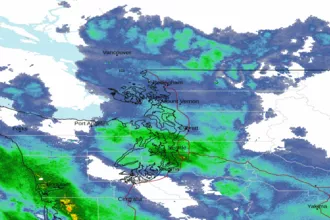 Seattle/Tacoma WA Radar
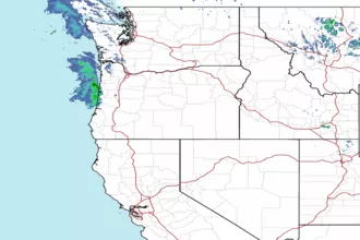 Northwest Radar