San Juan Islands and Northern Inland Waters Marine Forecast
| Tonight...Sw Wind Around 5 Kt, Veering To W Late. Waves Around 2 Ft Or Less. |
| Sun...Nw Wind 5 To 10 Kt. Waves Around 2 Ft Or Less. |
| Sun Night...Nw Wind Around 5 Kt. Waves Around 2 Ft Or Less. |
| Mon...Nw Wind Around 5 Kt. Waves Around 2 Ft Or Less. |
| Mon Night...Sw Wind Around 5 Kt, Backing To Se After Midnight. Waves Around 2 Ft Or Less. |
| Tue...Light And Variable Winds, Becoming W Around 5 Kt In The Afternoon. Waves Around 2 Ft Or Less. |
| Tue Night...Sw Wind Around 5 Kt, Backing To Se After Midnight. Waves Around 2 Ft Or Less. |
| Wed...Light And Variable Winds, Becoming W Around 5 Kt In The Afternoon. Waves Around 2 Ft Or Less. |
| Wed Night...Sw Wind Around 5 Kt. Waves Around 2 Ft Or Less. |
| Thu...S Wind Around 5 Kt. Waves Around 2 Ft Or Less. |
| Thu Night...S Wind Around 5 Kt. Waves Around 2 Ft Or Less. |
| Area Forecast Discussion National Weather Service Seattle WA 148pm PDT Sat July 18 2026 Synopsis Weak troughing aloft is moving toward the northeast, allowing high pressure to resume for the first half of the week. This will lead to much above normal temperatures and widespread areas of Moderate to locally Major HeatRisk levels. A pattern change is possible Thursday into Friday, with the potential for another round of monsoonal moisture reaching the area. Short Term - Tonight Through Monday Night Low pressure is actively moving off to the northeast, allowing for the ridge to build into the Northwest through the first half of the week. Temperatures tomorrow will be in the upper 70s to low 80s, climbing to the mid to upper 80s by Monday. This corresponds to widespread Moderate HeatRisk on Monday, especially from the Seattle Metro area southward into Olympia and the Chehalis Valley. Very light winds going offshore temporarily in the afternoon will lead to very dry conditions over the next several days. The coast will see marine stratus clouds tomorrow morning, with an increasingly limited eastward extent over the next several days as high pressure returns. Long Term - Tuesday Through Saturday The pattern is consistent with the ridge remaining the dominant feature in the region through the middle of the week. Temperatures climb into the upper 80s to low 90s on Tuesday, and then remain in the low 90s on Wednesday. Major HeatRisk values will be centered on typical urban heat islands, including the Bellevue area (60-65% chance of Major HeatRisk) and portions of south King County (50-60% chance of Major HeatRisk). Moderate HeatRisk levels return by Thursday, but the weather pattern beyond Wednesday seems a bit uncertain. Models are generally divergent on the solutions where some bring another influx of monsoonal moisture into the state and others keep the high pressure in place. This will be something that is monitored as more clarity evolves as the potential for additional lightning starts is still a risk after another round of hot and dry conditions. Right now, temperatures are forecast to begin falling late in the week and into next weekend. 21 Marine The overall pattern remains steady with high pressure centered offshore with lower pressure over land. This will maintain northwesterly winds over the coastal waters. Wind speeds will pick up tonight and through much of Sunday which will bring marginal Small Craft Advisory winds to the outer waters, but this will allow seas to pick up and become steep, with 6-8 ft seas at around 8 seconds. Winds and seas ease Sunday night, and winds look to remain light and seas below 6 ft through much of the week. An onshore push is expected late this afternoon and into tonight, bringing Small Craft Advisory winds through the Strait of Juan de Fuca. Onshore gradients will ease through the early part of next week as thermally-induced low pressure develops across western Washington and Oregon. Stronger onshore flow and pushes down the Strait look to resume in the latter half of the week. 62 Fire Weather Another period of hot and dry weather will increase fire weather concerns throughout the first half of the week. Temperatures climbing back into the upper 80s and low 90s with relative humidity values the drop into the 20 percent range are expected through Wednesday. While wind does not look to be a considerable factor in the elevated conditions, there will be periods of weak offshore flow that can still act to dry out the environment and make fuels more receptive. Beyond Wednesday, the pattern will need to be monitored as there is a suggestion of another influx of monsoonal moisture that could lead to another round of thunderstorms late in the week. Details on this will evolve throughout the first half of the week. 21 NOAA Seattle WA Office: Watches - Warnings - Advisories WA...None. PZ...Small Craft Advisory until 1am PDT Sunday for Central U.S. Waters Strait Of Juan De Fuca- East Entrance U.S. Waters Strait Of Juan De Fuca. Small Craft Advisory from 5pm this afternoon to 11pm PDT Sunday for Coastal Waters From Cape Flattery To James Island 10 To 60 Nm- Coastal Waters From James Island To Point Grenville 10 To 60 Nm- Coastal Waters From Point Grenville To Cape Shoalwater 10 To 60 Nm. |
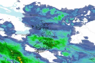 Seattle/Tacoma WA Radar
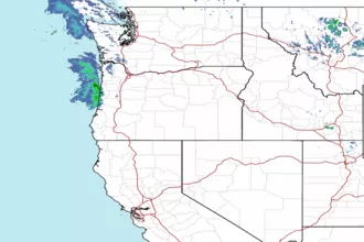 Northwest Radar