Manasquan Inlet to Little Egg Inlet NJ out 20 NM Marine Forecast
| Overnight...Ne Winds 5 To 10 Kt. Seas 3 To 4 Ft. Wave Detail: E 4 Ft At 8 Seconds. |
| Sat...Ne Winds 5 To 10 Kt. Seas 3 To 4 Ft. Wave Detail: E 4 Ft At 9 Seconds. A Chance Of Showers In The Afternoon. |
| Sat Night...Ne Winds 5 To 10 Kt. Seas 3 To 4 Ft. Wave Detail: E 4 Ft At 9 Seconds. A Chance Of Showers In The Evening. |
| Sun...Ne Winds Around 10 Kt With Gusts Up To 20 Kt. Seas 3 To 4 Ft. Wave Detail: E 4 Ft At 8 Seconds. |
| Sun Night...Ne Winds Around 10 Kt With Gusts Up To 20 Kt. Seas Around 3 Ft. Wave Detail: E 3 Ft At 8 Seconds. |
| Mon...Ne Winds 10 To 15 Kt With Gusts Up To 20 Kt. Seas 3 To 4 Ft. Wave Detail: E 3 Ft At 7 Seconds And Se 1 Foot At 11 Seconds. |
| Mon Night...E Winds 5 To 10 Kt. Seas 3 To 4 Ft. |
| Tue...Se Winds 5 To 10 Kt, Becoming S 10 To 15 Kt In The Afternoon. Seas Around 3 Ft. |
| Tue Night...S Winds 10 To 15 Kt, Diminishing To 5 To 10 Kt After Midnight. Seas Around 3 Ft. |
| Wed...S Winds 5 To 10 Kt, Increasing To 10 To 15 Kt In The Afternoon. Seas 2 To 3 Ft. |
| Wed Night...S Winds 10 To 15 Kt. Seas Around 3 Ft. |
| Area Forecast Discussion National Weather Service Mount Holly NJ 1004pm EDT Fri May 17 2024 Synopsis As low pressure continues to move farther away from our area through tonight, another area of low pressure slides to our south over the weekend. High pressure then builds across our area early next week before shifting to our south. A cold front then moves through Thursday into Friday. Near Term - Through Saturday Increasing high/mid clouds overnight as the next system approaches. Scattered showers are possible for the western areas overnight. Many of the models have the rains decreasing overnight. Patchy fog is possible overnight. Lows will drop into the low/mid 50s for most spots with some upper 50s for metro Philadelphia. Winds will be light tonight. On Saturday, a disorganized short wave will move from the upper Ohio Valley across the Middle Atlantic region. A weak surface low will accompany the feature. Clouds will have the upper hand much of the day and scattered to numerous showers will be across the area. Better chances for rains will be across Delmarva, south NJ and up into Berks County PA. These areas will be close to the better lift associated with the low/short wave. It'll remain cool with the clouds and rains, so high temperatures will likely only climb into the low/mid 60s. Winds will be light from the East or Southeast much of the time. Short Term - Saturday Night Through Monday Night Surface high pressure extends southward into our area later Saturday night and Sunday, with most of the energy now confined to the south of the area which will help to completely end the shower chances after Saturday evening. Some lingering low-level moisture though and especially if the clouds clear enough may result in patchy fog Saturday night into early Sunday. By Sunday afternoon, expect at least some sunshine to make a return. High temperatures top out into the 70s for many inland areas, although a lingering onshore flow will keep it much cooler closer to the coast. As an upper-level ridge starts to build over the area Monday, surface high pressure becomes more centered across our region. The increasing subsidence and drier air should assist in less cloud cover for much if not all of the region. The air mass will continue to modify and therefore afternoon high temperatures are forecast into the 70s again for much of the area. A northeast wind though should turn east to southeast as a sea breeze becomes more established and this will yet again keep it much cooler closer to the coast Monday. Long Term - Tuesday Through Friday Summary...Above average temperatures and dry to start, followed by some chances for showers/thunderstorms with a cold front. Some cooling then possible Friday. Synoptic Overview...An upper-level ridge is forecast to be across much of the East Tuesday before it shifts offshore Wednesday. An upper-level trough tracking eastward from south-central Canada to the mid-Mississippi Valley will drive surface low pressure well to our north. A cold front however is forecast to arrive across our area Thursday into Friday as the upper-level trough mostly glances the Northeast. The flow aloft then may turn more zonal into Friday, although a shortwave trough in the Tennessee Valley may make a run at our area later Friday. The latter is much more uncertain at this time range. For Tuesday and Wednesday...Given the presence of upper-level ridging overhead Tuesday along with high pressure at the surface, a warmer air mass will be in place. The light winds however should result in a sea breeze Tuesday afternoon which will then make a run inland keeping it cooler closer to the coast. This setup is expected to result in no precipitation and a decent amount of sunshine given the subsidence. As we go through Wednesday, more of a return flow should become established as the ridge aloft and also the surface high shifts offshore. Low-level warm air advection should increase some with this southerly flow ahead of an upper-level trough which drives surface low pressure and a cold front. The forward motion/timing of the cold front is less certain especially as the main upper-level trough may just glance the Northeast and the surface low tracks well to our north. It is possible a band or broken band of showers and thunder makes it into our far western zones late Wednesday tied to a surface trough. Given the initial subsidence and favorable setup, temperatures were bumped up some especially away from the coast. For Thursday And Friday The aforementioned upper-level trough glances our area Thursday however a cold front tied to low pressure well to our north should move through sometime during this time frame. There looks to be enough forcing to produce some showers and instability should be sufficient during the afternoon and evening Thursday for some possible thunderstorms. The warmth (and more humid) may peak Thursday ahead of the cold front with widespread low to mid 80s for highs, although probably cooler closest to the coast due to a southerly wind. As of now, the cold front should be offshore to start Friday with some cooling in its wake. The cooling does not look all that significant at this time given the weakness of the upper-level trough and it tending to just glance our region. Marine Fair tonight and then showers for Saturday. There is a better chance for showers across the southern NJ and Delaware waters as well as Delaware Bay. SCA (Small Craft Advisory) is not expected through Saturday. Outlook... Saturday night through Wednesday...The conditions are anticipated to be below Small Craft Advisory criteria. .Rip Currents... Winds are generally around 5 to 10 mph, and the rip current risk is no longer HIGH. Will therefore cancel the HIGH risk for rip currents that was set to expire at 8 pm. A prolonged period of N to NE winds at 5 to 10 mph through the weekend along with 3 to 4 ft seas will result in a MODERATE risk for the development of dangerous and life threatening rip currents on Saturday and Sunday. NOAA Mount Holly NJ Office: Watches - Warnings - Advisories PA...None. NJ...None. DE...None. MD...None. Marine None. |
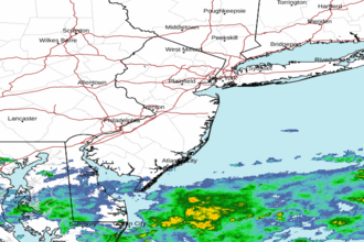 Mount Holly NJ Radar
 Northeast Radar
 East Coast Satellite