Penobscot Bay Marine Forecast
| Today...N Winds 15 To 20 Kt, Becoming Ne 10 To 15 Kt This Afternoon. Seas 2 To 4 Ft. Wave Detail: S 3 Ft At 7 Seconds. |
| Tonight...E Winds 10 To 15 Kt, Becoming Se 15 To 20 Kt After Midnight. Seas 2 To 4 Ft. Wave Detail: E 2 Ft At 3 Seconds And S 2 Ft At 7 Seconds. A Chance Of Showers After Midnight. |
| Sun...Se Winds 15 To 20 Kt, Becoming Sw 10 To 15 Kt In The Afternoon. Seas 2 To 4 Ft. Wave Detail: S 3 Ft At 5 Seconds. Showers. Patchy Dense Fog. Vsby 1 Nm Or Less. |
| Sun Night...W Winds 5 To 10 Kt. Seas 2 To 4 Ft. Wave Detail: S 4 Ft At 7 Seconds. Showers In The Evening. |
| Mon...W Winds 10 To 15 Kt With Gusts Up To 20 Kt. Seas 2 To 4 Ft. Wave Detail: S 3 Ft At 8 Seconds. |
| Mon Night...Nw Winds 5 To 10 Kt. Seas 2 To 4 Ft. Wave Detail: S 3 Ft At 7 Seconds. |
| Tue...Nw Winds Around 5 Kt, Becoming Sw In The Afternoon. Seas 2 To 3 Ft. A Chance Of Snow Showers In The Afternoon. |
| Tue Night...Nw Winds 10 To 15 Kt With Gusts Up To 20 Kt. Seas Around 2 Ft. A Chance Of Snow Showers In The Evening. |
| Wed...Nw Winds 5 To 10 Kt With Gusts Up To 20 Kt, Becoming Sw In The Afternoon. Seas Around 2 Ft. |
| Wed Night...Sw Winds 5 To 10 Kt, Increasing To 10 To 15 Kt After Midnight. Gusts Up To 25 Kt. Seas 2 To 4 Ft. |
| Area Forecast Discussion National Weather Service Gray ME 232am EDT Sat April 4 2026 .WHAT HAS CHANGED... No significant changes in the short term. Some increase in potential light snowfall late Tuesday or Tuesday night, especially across southern locations. .KEY MESSAGES... 1. Another round of soaking rain is expected Sunday, with a wintry mix possible in the mountains. 2. Drier and cooler weather is expected on Monday. There is then a low potential for some light snow or rain on Tuesday and Tuesday night. This will be followed by mainly dry conditions and moderating temperatures through the remainder of the week. KEY MESSAGE 1 DESCRIPTION... The next precipitation event will arrive late tonight and Sun, as low pressure tracks across southern Quebec. Model guidance agrees the strongest forcing and highest Quantitative Precipitation Forecast will be north and west of the forecast area. However, ensemble guidance also is fairly consistent that a solid soaking Quantitative Precipitation Forecast event is likely for the forecast area. There is roughly a 3 in 4 chance that most areas will see between 0.25 and 0.5 inches liquid by the time things are all said and done. I say liquid equivalent because there is a question of how cold do temps get in the interim between cold frontal passage and onset of precip. Mesoscale model guidance drops readings across the north below freezing this morning and then barely bring them up above freezing during the afternoon. This is especially true for the western Maine mtns. Temps then sink back a few more degrees this evening before showers arrive with the mid level warm front. The Winter Weather Advisory covers this area nicely already, and I do not foresee a reason to expand at this time. Across those same northern zones precipitation may end as snow showers, as the next cold front comes thru and mixes out the low level inversion. KEY MESSAGE 2 DESCRIPTION... High pressure will allow for a dry but cool day on Monday with northwesterly wind gusts up to 25-30 mph. High temperatures will be into the 30s across the north with 40s to near 50 degrees south. It will remain dry on Monday night with lows mostly into the 20s. Attention then turns towards Tuesday as there is some increasing potential that a weak wave of low pressure may ride far enough north at the base of an H5 s/wv trough axis to bring some light precipitation to the region. Temperature profiles currently support mainly snow but with the high April sun angle and marginal surface temperatures, accumulations during the daytime will be tough to achieve. Light snow and/or rain may continue through Tuesday evening before ending overnight. There remains significant forecast uncertainty though and Tuesday could become another dry day. Regardless, Tuesday night will be cold with lows falling into the teens across the north with lower to middle 20s south. Geopotential heigheights are then forecast to increase Wednesday through the end of the week as flow becomes increasingly out of the southwest. This will allow for a gradual moderating trend with temperatures potentially becoming above average by the end of the week. Mainly dry conditions also are likely. Marine A cold front crossing the waters will have offshore winds gusting to around 25 kt thru the mid morning. Later today winds will turn back onshore and steadily increase thru Sunday as another storm approaches. SCA (Small Craft Advisory) remains in effect for the westerly winds thru morning, but a new SCA (Small Craft Advisory) or extension is likely for the onshore winds thru Sunday night. Westerly wind gusts up to 30 kts are possible on Monday before becoming northerly Tuesday night-Wedam with gusts between 25-30 kts possible. Elevated seas of 3-7 ft outside of the bays are also possible on Monday. NOAA Gray/Portland ME Office - Watches - Warnings - Advisories ME...Winter Weather Advisory from midnight tonight to 10am EDT Sunday for MEZ007>009. NH...Winter Weather Advisory from midnight tonight to 10am EDT Sunday for NHZ001-002. Marine Small Craft Advisory until 2pm EDT this afternoon for ANZ150- 152. Small Craft Advisory until noon EDT today for ANZ151-154. |
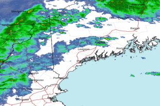 Portland ME Radar
 Northeast Radar