San Juan Islands and Northern Inland Waters Marine Forecast
| Tonight...Sw Wind 5 To 10 Kt, Backing To S Late. Waves Around 2 Ft Or Less. A Slight Chance Of Rain Late. |
| Fri...Se Wind 10 To 15 Kt, Easing To 5 To 10 Kt In The Afternoon. Waves Around 2 Ft Or Less. |
| Fri Night...S Wind Around 5 Kt, Backing To Ne After Midnight. Waves Around 2 Ft Or Less. |
| Sat...N Wind Around 5 Kt. Waves Around 2 Ft Or Less. |
| Sat Night...Nw Wind 5 To 10 Kt. Waves Around 2 Ft Or Less. |
| Sun...Nw Wind 5 To 10 Kt. Waves Around 2 Ft Or Less. |
| Sun Night...Nw Wind Around 5 Kt In The Evening, Becoming Light And Variable. Waves Around 2 Ft Or Less. |
| Mon...E Wind Around 5 Kt, Veering To S In The Afternoon. Waves Around 2 Ft Or Less. |
| Mon Night...Sw Wind 5 To 10 Kt. Waves Around 2 Ft Or Less. |
| Tue...W Wind 5 To 10 Kt. Waves Around 2 Ft Or Less. |
| Tue Night...W Wind Around 5 Kt. Waves Around 2 Ft Or Less. |
| Area Forecast Discussion National Weather Service Seattle WA 217pm PDT Thu April 2 2026 Synopsis Showers will taper off today as high pressure builds into Western Washington. This will kick off a warming and drying trend through the weekend and into early next week. Chances of precipitation increase towards the middle of next week as a series of troughs pass over British Columbia. Short Term - Tonight Through Saturday Night Lowland rain and mountain snow will continue to taper off throughout the day today as a low pressure system progresses further inland. Post-frontal convergence zone activity will linger between King and Snohomish Counties into the evening, bringing potential for locally heavy rain and breezy winds. Elsewhere, more benign conditions will settle into the region today under cloudy skies with some sun breaks and highs in the low 50s. An upper level ridge will continue to amplify into the region into Saturday, bringing in drier and warmer conditions. A weak system moving over Vancouver Island on Friday may bring light rain showers to the Olympic Peninsula and North Interior, but rainfall accumulations are expected to be minimal. Highs will warm up to near- normal on Friday with highs in the mid to upper 50s for most areas. The warming trend will continue on Saturday, with highs reaching the upper 50s to mid 60s for the lowlands. Long Term - Sunday Through Thursday Sunday and Monday will bring the warmest conditions of the year so far for most areas as high pressure remains overhead, with high temperatures in the upper 60s to low 70s. The warmest temperatures are favored across the south Sound and along the Cascade Foothills. This also introduces Minor (Yellow) HeatRisk for areas south and east of the Puget Sound on Sunday and Monday. While deterministic forecast models maintain dry conditions through much of next week, a series of troughs is set to move through British Columbia towards the middle of next week, with chances for light precipitation returning for western Washington. Marine Onshore low will gradually relax tonight as surface ridging over the coastal and offshore waters shifts into the interior of Western Washington. A weak front will clip the coastal waters on Friday, but is not expected to generate much in the way of impacts. A ridge will strengthen over area waters over the weekend with the flow turning northerly or weakly offshore as thermally induced low pressure expands northward along the Oregon coast. Onshore flow returns early next week as another frontal system passes north of the waters. This may generate a strong westerly push in the Strait of Juan de Fuca Monday night into Tuesday. Seas will straddle the 10 foot mark today before subsiding back into single digits Friday into the early portion of next week. 27 Hydrology No river flooding is expected over the next 7 days. NOAA Seattle WA Office: Watches - Warnings - Advisories WA...None. PZ...Small Craft Advisory until 8pm PDT this evening for Coastal Waters From Cape Flattery To James Island 10 To 60 Nm- Coastal Waters From Cape Flattery To James Island Out 10 Nm- Coastal Waters From James Island To Point Grenville 10 To 60 Nm- Coastal Waters From James Island To Point Grenville Out 10 Nm- Coastal Waters From Point Grenville To Cape Shoalwater 10 To 60 Nm- Coastal Waters From Point Grenville To Cape Shoalwater Out 10 Nm Grays Harbor Bar. Small Craft Advisory until 10pm PDT this evening for Central U.S. Waters Strait Of Juan De Fuca- East Entrance U.S. Waters Strait Of Juan De Fuca. |
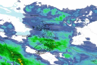 Seattle/Tacoma WA Radar
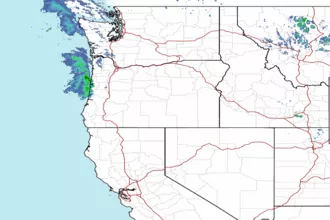 Northwest Radar