Chesapeake Bay from Drum Point MD to Smith Point VA Marine Forecast
| Today...E Winds 10 To 15 Kt With Gusts To 20 Kt. Waves 1 To 2 Ft. |
| Tonight...E Winds 10 To 15 Kt With Gusts To 20 Kt. Waves 2 Ft. |
| Sat...Se Winds 10 To 15 Kt With Gusts To 20 Kt. Waves 2 Ft. |
| Sat Night...S Winds 10 To 15 Kt With Gusts To 20 Kt. Waves 2 Ft. |
| Sun...S Winds 10 Kt. Waves 2 Ft. |
| Sun Night...Sw Winds 10 Kt. Waves 2 Ft. |
| Mon...Sw Winds 5 To 10 Kt...Becoming S. Waves 1 To 2 Ft. |
| Tue...S Winds 10 To 15 Kt...Becoming Sw After Midnight. Waves 2 Ft. |
| Area Forecast Discussion National Weather Service Baltimore MD/Washington DC 1015am EDT Fri April 26 2024 Synopsis Surface high pressure moves south along the eastern Appalachians today into Saturday. Cooler temperatures prevail as a result along, with increased cloud cover and showers on Saturday. A warm front lifts through the area this weekend bringing a significant warm up Sunday and Monday. The next chance for widespread precipitation arrives with a cold front Tuesday into Wednesday next week. Near Term - Through Tonight Upper level ridging will begin building from the west through tonight. A surface high over southern New England begins to slide south into the western Atlantic Ocean. Dry conditions expected today. However, onshore flow continues to result in clouds banked against the central Appalachians. Guidance indicates some thinning of the cloud deck as mixing of dry air increases through this afternoon. In general, more clouds are expected with southwestward extend from DC. Below normal temperatures continue today as highs reach the low to mid 60s. Not as cool tonight, with lows settling in the low to mid 40s. Short Term - Saturday Through Sunday Night A mid-level trough over the Northern Plains ejects east over the Great Lakes Saturday. Most of the energy associated with this system remains well to our west, though some weak vorticity riding atop the ridge aloft will make its way over our area. Combined with a warm front lifting north there will be scattered shower activity, especially west of US-15. Given the slow moving nature of this system, Saturday looks to be cloudy and at time showery. This keeps highs slightly cooler in the upper 50s to low 60s. Though, much milder Saturday night as lows settle in the 50s. Deep ridging engulfs much of the Southeast and Mid-Atlantic Sunday, bringing a return of dry, partly cloudy, and significantly warmer conditions. An early taste of summer Sunday as highs reach the low to mid 80s, which is about 20-25 degrees higher than Saturday. A few showers or thunderstorms could develop west of the Blue Ridge Sunday afternoon, though given the deep mixing and dry low-levels any convective activity will be short lived. Even milder Sunday night as lows settle in the upper 50s to low 60s. Long Term - Monday Through Thursday A strong upper ridge remains overhead on Monday with anomalously warm temperatures to start the work week. Highs well into the 80s are forecast Monday and Tuesday, though a few degrees cooler Tuesday with the increased cloud cover as high pressure moves offshore and a weak cold front approaches from the west. The frontal passage isn't expected to bring much relief from the heat, however. Showers and thunderstorms could accompany the front in the afternoon and evening and some could be strong to severe. Decent instability will be available, but guidance has been weaker on the shear. Will continue to monitor. A weaker shortwave moves through on Wednesday, with more potential for showers and thunderstorms. The environment will be similar as far as instability and shear, but with weaker forcing. Guidance diverges heading into late week, but thus far above average temperatures are expected to continue with possibly some relief near the end of the week or into the weekend. Marine Onshore flow will continue through tonight. Periods of SCA (Small Craft Advisory) conditions are likely across most of the waters, especially the open waters of the Chesapeake Bay through Saturday night. Southeast winds are likely to result in several hours of gusts to around 20 knots this afternoon to evening, so a Small Craft Advisory has been issued. For Saturday, southerly channeling is likely to result in additional SCA (Small Craft Advisory) winds during the evening hours. High pressure builds across the region Sunday, likely keeping southwest winds at 10 knots or less. Westerly flow to start on Monday becomes southerly in the evening. Winds may approach SCA (Small Craft Advisory) criteria on Tuesday as a weak cold front moves through the area, and stronger gusts will be possible with any showers and thunderstorms passing over the waters. Winds become westerly behind the front Tuesday night. Tides / Coastal Flooding Coastal Flood Advisories are in effect for some locations for this morning's high tide. This is due in part to increased northeast to easterly flow eventually switching to the south/southeast this weekend. The potential for coastal flooding continues Saturday as southerly flow persists, with several sites approaching or exceeding minor. NOAA Baltimore MD/Washington DC Office: Watches - Warnings - Advisories DC...Coastal Flood Advisory until 1pm EDT this afternoon for DCZ001. MD...Coastal Flood Advisory until 1pm EDT this afternoon for MDZ011. Coastal Flood Advisory until noon EDT today for MDZ014. Coastal Flood Advisory until 2pm EDT this afternoon for MDZ508. VA...None. WV...None. Marine Small Craft Advisory from 7pm this evening to 2am EDT Saturday for ANZ530>533-536-538>542. Small Craft Advisory from 5pm this afternoon to 4am EDT Saturday for ANZ534-537-543. Small Craft Advisory from 7pm this evening to midnight EDT tonight for ANZ535. |
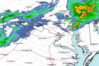 Baltimore/Washington Radar
 Northeast Radar
 East Coast Satellite