Chesapeake Bay from North Beach to Drum Point MD Marine Forecast
| Today...N Winds 5 To 10 Kt...Becoming Se Late. Waves 1 Ft. |
| Tonight...S Winds 15 To 20 Kt. Waves 2 To 3 Ft. |
| Wed...S Winds 15 To 20 Kt With Gusts To 25 Kt. Waves 3 Ft. |
| Wed Night...S Winds 15 To 20 Kt...Becoming Sw 10 To 15 Kt After Midnight. Gusts Up To 25 Kt. Waves 2 To 3 Ft. Showers With A Chance Of Tstms. |
| Thu...Nw Winds 10 To 15 Kt With Gusts To 20 Kt. Waves 2 Ft. |
| Thu Night...Nw Winds 10 To 15 Kt With Gusts To 20 Kt. Waves 2 Ft. |
| Fri...Nw Winds 15 To 20 Kt...Becoming W Around 5 Kt. Waves 1 To 2 Ft...Subsiding To Flat After Midnight. |
| Sat...Sw Winds 5 To 10 Kt. Waves 1 Ft Or Less. Winds And Waves Higher And Visibilities Lower In And Near Tstms. |
| Area Forecast Discussion National Weather Service Baltimore MD/Washington DC 1032am EDT Tuesday May 12 2026 .WHAT HAS CHANGED... Nothing. .KEY MESSAGES... 1) Gusty thunderstorms are possible Wednesday afternoon and evening. 2) After another cool down, above average temperatures return for the weekend into early next week. KEY MESSAGE 1...Gusty thunderstorms are possible Wednesday afternoon and evening. A trough diving southeast from central Canada will drive a surface low across the Great Lakes on Wednesday. Gusty southerly winds will battle increasing clouds to push temperatures into the 70s. A lead vort max may result in an initial round of showers moving across the area during the daytime. It's uncertain how far east these will make it with residual dry air in place. Either way, very little instability will be available for this first round, even though the showers could be reaching areas east of the Blue Ridge during the afternoon. A second round of convection is expected to develop west of the Appalachian crest closer to the main trough axis and surface cold front. While shear will be sufficient for organization, instability will be lacking. Most models show this activity crossing the mountains during the late afternoon, then affecting areas east of the Blue Ridge during the evening. While some stronger thunderstorms could occur across western areas, a gradual diminishing trend is expected with eastward extent. SPC has maintained a Marginal/Level 1 Risk for western portions of the area. The main threat will be strong to locally damaging winds. KEY MESSAGE 2...After another cool down, above average temperatures return for the weekend into early next week. The earlier mid-week trough is expected to close off in the vicinity of the upper Mid-Atlantic to southern New England on Thursday. Not only will this keep temperatures cooler with some enhanced cloud cover, scattered mountain showers look possible during the daytime hours. Surface high pressure builds over the region on Friday. Temperatures start to creep back up to the low 70s on Friday and then quickly rise as upper level ridging builds and warm air from southwest CONUS moves into the region. Highs for Saturday and Sunday are forecasted to broadly range in the 80s, and early temperature outlooks for Monday show highs reaching the 90s as persistent upper level ridging continues. There are some hints a shortwave trough may bring shower and thunderstorm potential at some point between Saturday and Sunday, although model spread in this feature remains large. Drier air moves into the region at the start of next week as upper level ridging builds, minimizing additional rain chances. Marine Southerly flow will take hold this afternoon, increasing tonight as high pressure departs. Gusts of 20 to 25 knots will be commonplace across a majority of the waters, especially by Wednesday. While wind gust forecasts are tricky on the interior waterways during the overnight, have eventually all waters entering a Small Craft Advisory tonight. The current advisory continues through 6pm Wednesday, although it will likely need to be extended into the evening. Some late afternoon to evening thunderstorms. could impact the waters as the cold front approaches from the west. Any stronger storm may require Special Marine Warnings. Winds shift to west-northwesterly early Thursday behind the cold front. Winds will increase through the day, and advisories will likely be needed. SCA (Small Craft Advisory) conditions likely continue through Friday afternoon. Winds fall below SCA (Small Craft Advisory) criteria by Friday evening. Northwest winds shift southerly by Saturday afternoon. Tides / Coastal Flooding Expect a gradual uptick in water levels ahead of a mid-week low pressure system. The influence of increasing southerlies will carry the tidal forecast to action stage at several locations during times of high tide. The Stevens ensemble shows the potential for Minor tidal flooding by early Thursday at Annapolis. Expect anomalies to fall thereafter as winds shift to northwesterly. NOAA Baltimore MD/Washington DC Office: Watches - Warnings - Advisories DC...None. MD...Small Craft Advisory from 2am to 6pm EDT Wednesday for MDZ008. VA...None. WV...None. Marine Small Craft Advisory from 2am to 6pm EDT Wednesday for ANZ530-535>539-542. Small Craft Advisory from 10pm this evening to 6pm EDT Wednesday for ANZ531>534-540-541-543. |
 Baltimore/Washington Radar
 Northeast Radar
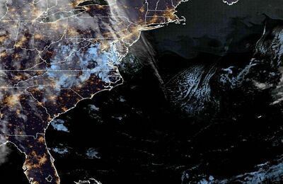
 East Coast Satellite