Admiralty Inlet Marine Forecast
| Today...Nw Wind Around 5 Kt, Rising To 5 To 10 Kt Late This Morning And Afternoon. Waves Around 2 Ft Or Less. |
| Tonight...Nw Wind 5 To 10 Kt In The Evening, Becoming Light And Variable. Waves Around 2 Ft Or Less. |
| Thu...Nw Wind Around 5 Kt. Waves Around 2 Ft Or Less. |
| Thu Night...Nw Wind 20 To 25 Kt, Becoming Sw 15 To 20 Kt After Midnight. Waves Around 2 Ft Or Less, Then 3 To 4 Ft After Midnight. A Chance Of Rain After Midnight. |
| Fri...Sw Wind 10 To 15 Kt, Veering To Nw In The Afternoon. Waves 3 To 4 Ft. A Chance Of Rain. |
| Fri Night...W Wind 15 To 20 Kt. Waves 3 To 4 Ft. |
| Sat...Sw Wind 5 To 10 Kt, Veering To Nw In The Afternoon. Waves Around 2 Ft Or Less. |
| Sat Night...Nw Wind 15 To 20 Kt, Becoming W 10 To 15 Kt After Midnight. Waves Around 2 Ft Or Less, Then Around 3 Ft After Midnight. |
| Sun...Sw Wind 5 To 10 Kt, Veering To Nw In The Afternoon. Waves Around 2 Ft Or Less. |
| Sun Night...W Wind 5 To 10 Kt. Waves Around 2 Ft Or Less. |
| Area Forecast Discussion National Weather Service Seattle WA 826am PDT Wednesday May 27 2026 Synopsis Upper level low well to the south with a weak upper level ridge nosing into Western Washington today and tonight. The low will drift north Thursday while an upper level trough begins to exit the Gulf of Alaska. Low weakening and moving east Thursday night into Friday. Weak upper level trough settling over Western Washington later Friday into Saturday. The trough will give way to a building upper level ridge late Sunday. The ridge will continue to build the first part of next week. Short Term - Today through Friday Satellite imagery shows a mixed bag of weather conditions over Western Washington early this morning. Clear skies along the I-5 corridor and the North Coast with cloudy skies elsewhere. Temperatures at 3 am/10z were in the mid 40s to mid 50s. Upper level low well to the south today with moisture associated with the low only as far north as Oregon or over Eastern Washington. Clouds over Western Washington this morning will dissipate later this morning into the afternoon leaving mostly sunny skies. Warm air moving up from the south around the low combining with the sunshine today pushing high temperatures into the 70s over the interior. Along the coast highs in the mid to upper 60s. Little change in the pattern tonight. Light onshore flow in the lower levels with stratus developing along the coastline spreading into the Lower Chehalis Valley at best. Lows in the mid 40s to mid 50s. Upper level low starting to drift north Thursday with moisture spinning around the low reaching the area late in the day. Air mass slightly unstable with plenty of daytime heating creating a chance of showers over the Cascades late in the afternoon. Continued warm over the interior with highs in the 70s and lower 80s. Highs along the coast mid 60s. Upper level low weakening and moving east Thursday night into Friday while an upper level trough approaches the coast. Showers with a slight chance of thunderstorms over the Cascades Thursday night with showers spreading into the interior lowlands Friday morning. In the lower levels the flow turning strong onshore with possible gales in the Strait of Juan de Fuca adding moisture. End result increasing clouds Thursday night with a cloudy Friday along with the showers over the Cascades and interior in at least the morning. Highs much cooler, near 60 Long Term - Friday Night Through Tuesday Models in good agreement with upper level troughiness over Western Washington through Saturday night. Not much moisture aloft associated with the trough but onshore flow will provide some moisture to the lower levels especially Saturday. No showers in the forecast just morning clouds with some afternoon sunshine Saturday. More sunshine and less morning clouds Sunday. Highs upper 50s to mid 60s Saturday and 60s Sunday. Upper level ridge building over Western Washington from the south beginning Sunday night and continuing through Tuesday. 500 mb heigheights up to the mid 580 dms by Tuesday. Thermally induced surface trough developing along the coast Monday night remaining in place Tuesday. Highs in the upper 60s and 70s Monday warming to the 70s and lower 80s Tuesday. Lows in the upper 40s to mid 50s. Marine Surface high pressure will remain centered well offshore into Thursday producing onshore flow across the waters. Low pressure will deepen over the interior of British Columbia and east of the Cascades late Thursday and Friday. This will act to increase onshore flow. As a result, there is a high likelihood of gales in the central and east Strait of Juan de Fuca Thursday evening and a watch has been issued. Gusty northwesterly winds are expected across the outer coastal waters. Short period steep seas in addition to longer period swell arriving will lead to hazardous seas. Seas and winds will subside and ease toward the weekend as a building surface ridge expands into the interior waters allowing onshore gradients to gradually relax. 27 Hydrology The daily hydrology discussion has ended until the start of the next rainy season; it will only be updated during this time as needed. NOAA Seattle WA Office: Watches - Warnings - Advisories WA...None. PZ...Gale Watch from Thursday afternoon through late Thursday night for Central U.S. Waters Strait Of Juan De Fuca- East Entrance U.S. Waters Strait Of Juan De Fuca. Small Craft Advisory until 5pm PDT Thursday for Coastal Waters From Cape Flattery To James Island 10 To 60 Nm- Coastal Waters From Cape Flattery To James Island Out 10 Nm- Coastal Waters From James Island To Point Grenville 10 To 60 Nm- Coastal Waters From James Island To Point Grenville Out 10 Nm- Coastal Waters From Point Grenville To Cape Shoalwater 10 To 60 Nm- Coastal Waters From Point Grenville To Cape Shoalwater Out 10 Nm. |
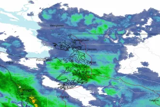 Seattle/Tacoma WA Radar
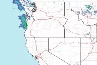 Northwest Radar