Puget Sound and Hood Canal Marine Forecast
| Tonight...N Wind 5 To 10 Kt, Easing To Around 5 Kt After Midnight. Waves Around 2 Ft Or Less. |
| Tue...N Wind Around 5 Kt, Rising To 5 To 10 Kt In The Afternoon. Waves Around 2 Ft Or Less. |
| Tue Night...N Wind 5 To 10 Kt, Becoming Nw After Midnight. Waves Around 2 Ft Or Less. |
| Wed...Sw Wind Around 5 Kt, Veering To Nw In The Afternoon. Waves Around 2 Ft Or Less. |
| Wed Night...Nw Wind 5 To 10 Kt, Becoming W After Midnight. Waves Around 2 Ft Or Less. A Chance Of Rain After Midnight. |
| Thu...Sw Wind Around 5 Kt, Veering To Nw In The Afternoon. Waves Around 2 Ft Or Less. A Chance Of Rain In The Morning, Then A Chance Of Showers In The Afternoon. |
| Thu Night...Nw Wind 5 To 10 Kt, Backing To Sw After Midnight. Waves Around 2 Ft Or Less. A Chance Of Rain In The Evening. |
| Fri...S Wind 5 To 10 Kt, Veering To Sw In The Afternoon. Waves Around 2 Ft Or Less. |
| Fri Night...Nw Wind 5 To 10 Kt, Backing To W After Midnight. Waves Around 2 Ft Or Less. |
| Sat...S Wind Around 5 Kt, Veering To W In The Afternoon. Waves Around 2 Ft Or Less. |
| Sat Night...Nw Wind 5 To 10 Kt, Easing To Around 5 Kt After Midnight. Waves Around 2 Ft Or Less. |
| Area Forecast Discussion National Weather Service Seattle WA 346pm PDT Monday July 13 2026 Synopsis High pressure aloft will rebuild across the region into Wednesday for warm and drier conditions. An area of low pressure may bring a threat of showers and thunderstorms around Thursday before high pressure regains control over the weekend for a return of dry conditions and well above normal temperatures. Short Term - Tonight Through Wednesday Night Mostly clear conditions this afternoon across Western Washington with localized stratus along the coast. High pressure will continue to build over the region as an area of low pressure dives southwards well offshore. Dry, warm conditions continue for the majority of the area through Wednesday. Temperatures will warm into the 80s for much of the interior Tuesday into Wednesday, resulting in continued Minor HeatRisk and areas of Moderate HeatRisk. Although POPs remain very low on Wednesday afternoon, will need to monitor the threat for convection over the Cascades with increasing instability. Otherwise, haze aloft will be around into midweek with continued southerly flow. Long Term - Thursday Through Monday Uncertainty increases in ensembles for Thursday into Friday as the upper low located offshore meanders closer to the Pacific Northwest. However, there has been an uptick in POPs for the Thursday period on the NBM. Looking at Cluster Analysis, ECMWF/CMC ensembles generally bring the upper low track closer to W WA by Thursday, with the GEFS maintaining more of an offshore solution (more ridging over W WA). Dependent on the track, there is a threat for showers and thunderstorms during this period with more S/SE flow aloft. Given the potential in elevated instability, convection could occur during the overnight and morning periods as well, from late Wednesday night into early Friday. This will need to be monitored closely as this would pose a fire weather concern, as well as impact any outdoor events. Upper level ridging is then expected to build next weekend into early next week, resulting in the return of dry conditions and warming temperatures. The threat for Moderate HeatRisk increases early next week, with widespread probabilities of 50% or greater for Moderate HeatRisk. Marine Surface high pressure will remain over the coastal waters throughout the next couple of days. Diurnally driven westerly pushes down the Strait of Juan De Fuca will continue, with a Small Craft Advisory out for this evenings push. The coastal waters may see a few wind gusts up to 20 kts on Thursday and Friday as a low pressure system tracks through the waters, but confidence is low at this time. Coastal seas remain at 4 to 6 feet through midweek, with seas slightly increasing to 7 to 8 feet with periods of 6 to 8 seconds. Mazurkiewicz Fire Weather Warming temperatures are on track through the middle of the week, with minimum relative humidity values dipping into the upper 20 to low 30 percent range throughout western Washington. A bit of a change is possible by midweek as thunderstorms get reintroduced into the forecast for Thursday. While this forecast is still highly variable, the potential for new ignitions on dry fuels due to lightning strikes is of notable concern. Less is known about exact rain amounts and whether these storms will contain wetting rains, but these details will become more available over the next few forecast cycles. It's important to note that even if thunderstorms do not occur, elevated fire weather conditions are likely to persist due to the warmer and drier weather that is forecast to continue well into the weekend. 21 NOAA Seattle WA Office: Watches - Warnings - Advisories WA...None. PZ...Small Craft Advisory from 5pm this afternoon to 1am PDT Tuesday for Central U.S. Waters Strait Of Juan De Fuca- East Entrance U.S. Waters Strait Of Juan De Fuca. |
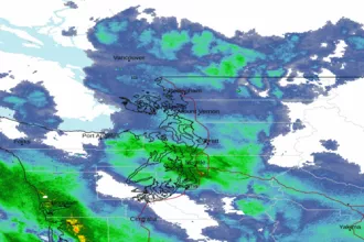 Seattle/Tacoma WA Radar
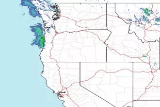 Northwest Radar