Suwannee River to Keaton Beach out 20 NM Marine Forecast
| Today...Southeast Winds 10 To 15 Knots, Diminishing To 5 To 10 Knots This Afternoon. Seas Around 3 Feet This Morning, Then 1 Foot Or Less. Wave Detail: Southeast 3 Feet At 5 Seconds, Becoming South 2 Feet At 5 Seconds. Protected Waters A Moderate Chop. A Slight Chance Of Showers Until Late Afternoon. A Slight Chance Of Thunderstorms Early This Afternoon, Then A Chance Of Showers And Thunderstorms Late. |
| Tonight...Northeast Winds 5 To 10 Knots, Becoming East 10 To 15 Knots After Midnight. Waves 1 Foot Or Less, Then Around 3 Feet After Midnight. Wave Detail: South 2 Feet At 5 Seconds, Becoming South 3 Feet At 6 Seconds. Protected Waters A Moderate Chop. A Slight Chance Of Showers And Thunderstorms In The Evening. |
| Saturday...Southeast Winds 10 To 15 Knots. Seas Around 3 Feet. Wave Detail: South 3 Feet At 7 Seconds. Protected Waters A Moderate Chop. |
| Saturday Night...West Winds Around 5 Knots, Becoming East Around 5 Knots After Midnight. Seas Around 3 Feet. Wave Detail: South 3 Feet At 7 Seconds. Protected Waters Smooth. |
| Sunday...Southeast Winds 5 To 10 Knots. Seas Around 3 Feet In The Morning, Then 1 Foot Or Less. Wave Detail: South 2 Feet At 7 Seconds, Becoming South 2 Feet At 6 Seconds. Protected Waters A Light Chop. |
| Sunday Night...West Winds 5 To 10 Knots, Becoming Northwest After Midnight. Waves 1 Foot Or Less. Wave Detail: South 2 Feet At 6 Seconds. Protected Waters A Light Chop. A Slight Chance Of Thunderstorms. A Slight Chance Of Showers In The Evening, Then A Chance Of Showers After Midnight. |
| Monday...North Winds 10 To 15 Knots. Seas Around 3 Feet. Protected Waters A Moderate Chop. A Slight Chance Of Thunderstorms In The Morning. A Chance Of Showers. |
| Monday Night...Northeast Winds 15 To 20 Knots. Seas 3 To 4 Feet. Protected Waters Choppy. A Chance Of Showers. |
| Tuesday...Northeast Winds 15 To 20 Knots. Seas 3 To 4 Feet. Protected Waters Choppy. A Chance Of Showers. |
| Tuesday Night...Northeast Winds 15 To 20 Knots, Increasing To 20 To 25 Knots After Midnight. Seas 3 To 5 Feet, Occasionally To 6 Feet. Protected Waters Rough. A Slight Chance Of Showers In The Evening. Winds And Waves Higher In And Near Thunderstorms. |
| Area Forecast Discussion National Weather Service Tallahassee FL 651am EDT Fri April 3 2026 .SHORT TERM... (Today and Tonight) Issued at 254am EDT Fri April 3 2026 Satellite observations show a shortwave trough tracking across the Lower MS Valley and fog/low stratus developing east of Mobile Bay. The former will provide forcing for scattered showers and thunderstorms focusing from the East FL Big Bend into SW GA, especially around the I-75 corridor. An unseasonably moist airmass supports multi-cell clusters/mergers capable of strong-gusty winds, frequent lightning, and locally heavy rainfall. In fact, local CAMs show probabilities up to 20-25% of isolated 3-inch pockets with an excess of 2 inches as a "reasonable worst case" along/south of the I-75. Such amounts could produce short-lived runoff issues, ponding of water, or nuisance flooding in urban/low-lying/poor- drainage locations. Convection should gradually diminish after sunset as diurnal instability wanes. High temperatures are forecast to be in the low to mid 80s while lows merely drop to the low 60s. Patchy fog encroaches on the western and eastern flanks of the Tri-State area late tonight. Beachgoers are urged to continue monitoring beach flags if visiting as a high risk of rip currents persist into the weekend despite the warm, inviting weather. Long Term (Saturday through Thursday) Issued at 254am EDT Fri April 3 2026 For tomorrow, rain chances shift to SE AL, Flint River Valley, and parts of the inland FL Panhandle. Showers and thunderstorms look to drift NE through the afternoon in a summer-like fashion where there isn't much organization, but rather pulsy loose cell structures occasionally clustering together and/or producing new cells via outflow boundaries. Attention then turns to an extensive cold front marching into the region some time on Easter Sunday. This boundary will be accompanied by widely scattered showers and thunderstorms, some of which could be strong. Confidence is lower than normal on the prospects for severe weather thanks in part to some continued uncertainty on the front's arrival. A daytime passage would theoretically raise chances for more robust convection as diurnal instability increases. Even so, fleeting upper-level support and max modeled deep-layer shear around 20-25 kts suggests a low likelihood of severe thunderstorms. Regardless, widespread beneficial rains are expected with this system, something that we definitely need given our ongoing/worsening drought situation. Drier conditions filter in behind the front via northerly winds going into Monday. However, an active southern stream impulse forces a wave of low pressure off the TX coast that then traverses the Gulf. The track of this feature will play an important role on any further rainfall following Sunday's event. The best chances for seeing another round of precipitation is along the coastal strip into the Suwannee Valley. However, this current model cycle has trended southward with the Gulf wave (i.e., ECMWF/CMC) with the GFS (Global Forecast System) a bit more north. Inland locations likely dry out completely by late Tuesday or early Wednesday. Highs mainly in the low 80s are forecast on Sunday afternoon, then get knocked down into the 70s through mid next week. Lows in the low 60s Sunday morning cool to the 50s for the remainder of the period. Marine Issued at 254am EDT Fri April 3 2026 A persistent subtropical ridge of high pressure maintains gentle to moderate easterly breezes through this weekend with daily afternoon seabreezes and nightly landbreeze surges. A passing front some time Sunday afternoon or evening causes winds to veer southerly and southwesterly. Winds then quickly freshen out of the north following frontal passage and approach advisory levels west of Apalachicola by Monday morning. Rainy weather is likely to persist into mid week from a wave low pressure traversing the Gulf. The chances for advisory winds and seas increase on Tuesday and persist the remainder of the work week. Fire Weather Issued at 254am EDT Fri April 3 2026 Expect a more convectively active afternoon today compared to yesterday. Scattered showers and thunderstorms are poised to focus the most from the SE FL Big Bend into SW GA, especially around the I- 75 corridor. Convection will be capable of strong-gusty- erratic winds, frequent lightning, and potential locally wetting rains. Overall rain chances decrease with westward extent - i.e., less coverage over the Central Timezone counties. For tomorrow afternoon, the convective focus flips to the inland FL Panhandle towards the Wiregrass-Flint River Valley with the best chances over SE AL. On Sunday, a cold front gradually pushes through the Tri-State area and will be accompanied by widely scattered showers and thunderstorms with increasing winds out of the SW ahead of it. The latter fosters high afternoon dispersion potential across parts of the FL Big Bend & South-Central GA. Some storms may be strong. Wetting rains appear likely along/NW of an Albany-Marianna- DeFuniak Springs line. After a prolonged period of prevailing east to southeast winds, we see a switch out of the north on Monday following frontal passage. However, conditions do not look to completely dry out as a wave of low pressure traverses eastward across the Gulf. This system keeps rain chances in the forecast early next week - best potential along the coast into the Suwannee Valley. Hydrology Issued at 254am EDT Fri April 3 2026 The best chances for rain over the next several days are today and Sunday, which will be much welcomed given our ongoing extreme (D3) to exceptional (D4) drought conditions. Yesterday, we saw further D3- D4 expansion. Additional rainfall is likely early next week, especially along the coastal strip into the Suwannee Valley. Current amounts are up to about 1.25 inches (isolated higher) east of the Apalachicola River. Values are subject to change. For more local drought information & statements, visit the following websites: weather.gov/tae/LocalDrought weather.gov/tae/DroughtInformationStatement NOAA Tallahassee FL Office: Watches - Warnings - Advisories FL...High Rip Current Risk through late Saturday night for FLZ108-112- 114-115. GA...None. AL...None. GM...None. |
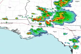 Tallahassee FL Radar
 Gulf Radar