Coupeville, WA Weather Forecast
Marine Forecast: San Juan Islands and Northern Inland Waters
Coupeville, Washington
Lat: 48.22N, Lon: 122.69W
Mostly Clear
Temp: 47°F
- Humidity:
- 92%
- Winds:
- 3 MPH ESE
- Gusts:
- N/A MPH
- Barometer:
- 30.08 in.
- Dewpoint:
- 45°F
- Heat index:
- 47°F
- Sunrise:
- 5:23 AM PDT
- Sunset:
- 9:06 PM PDT
- Moonrise:
- 5:25 AM PDT
- Moonset:
- 9:50 PM PDT
| Today...Sunny. Highs in the 70s. Light wind becoming north around 10 mph in the afternoon. |
| Tonight...Mostly clear. Lows in the lower to mid 50s. Northwest wind 10 to 15 mph becoming southwest after midnight. |
| Wednesday...Partly sunny in the morning then becoming sunny. Highs in the 70s. Light wind becoming northwest around 10 mph in the afternoon. |
| Wednesday Night...Mostly clear. A slight chance of rain after midnight. Lows in the 50s. Northwest wind 10 to 15 mph becoming west after midnight. |
| Thursday...Mostly cloudy with rain likely. Rainfall amounts a tenth to a quarter of an inch possible. Highs in the 70s. Light wind becoming northwest around 10 mph in the afternoon. |
| Thursday Night...Mostly cloudy with rain likely in the evening, then partly cloudy with a slight chance of rain after midnight. Lows in the lower to mid 50s. |
| Friday...Partly sunny with a slight chance of rain. Highs in the lower to mid 70s. |
| Friday Night...Mostly clear. Lows in the lower to mid 50s. |
| Saturday...Mostly sunny. Highs in the lower to mid 70s. |
| Saturday Night...Mostly clear. Lows in the lower to mid 50s. |
| Sunday...Mostly sunny. Highs in the 70s. |
| Sunday Night...Mostly clear. Lows in the mid 50s. |
| Monday...Mostly sunny. Highs in the mid 70s to lower 80s. && temperature / precipitation port townsend 74 54 75 / |
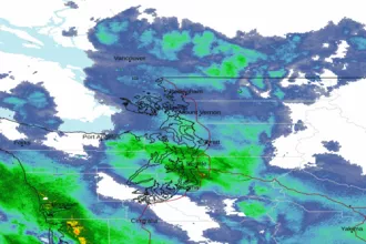 Seattle/Tacoma WA Radar
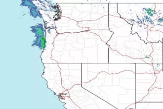 Northwest Radar