Puget Sound and Hood Canal Marine Forecast
| Today...N Wind Around 5 Kt, Backing To Sw 10 To 15 Kt Late. Waves Around 2 Ft Or Less. |
| Tonight...S Wind 10 To 15 Kt. Waves Around 2 Ft Or Less. A Chance Of Rain. |
| Wed...S Wind 10 To 15 Kt, Rising To 15 To 20 Kt In The Afternoon. Waves Around 2 Ft Or Less. Rain Likely, Mainly In The Morning. |
| Wed Night...Sw Wind 15 To 20 Kt, Easing To 10 To 15 Kt After Midnight. Waves Around 2 Ft Or Less. A Chance Of Rain In The Evening. |
| Thu...S Wind 5 To 10 Kt, Becoming Sw 10 To 15 Kt In The Afternoon. Waves Around 2 Ft Or Less. |
| Thu Night...Sw Wind 10 To 15 Kt, Becoming S 5 To 10 Kt After Midnight. Waves Around 2 Ft Or Less. A Chance Of Rain In The Evening. |
| Fri...Sw Wind 10 To 15 Kt. Waves Around 2 Ft Or Less. A Chance Of Rain In The Morning, Then Showers Likely In The Afternoon. |
| Fri Night...Sw Wind 10 To 15 Kt, Becoming S 5 To 10 Kt After Midnight. Waves Around 2 Ft Or Less. Showers Likely In The Evening. |
| Sat...Sw Wind 5 To 10 Kt, Veering To W In The Afternoon. Waves Around 2 Ft Or Less. A Chance Of Rain. |
| Sat Night...Nw Wind 5 To 10 Kt, Becoming S After Midnight. Waves Around 2 Ft Or Less. |
| Area Forecast Discussion National Weather Service Seattle WA 307am PDT Tuesday May 12 2026 Synopsis A lingering ridge of high pressure will bring one more day of warm temperatures to western Washington today. A transition to onshore flow and cooler conditions will take place on Wednesday along with a chance of some precipitation. Cooler and unsettled conditions will continue into the weekend as a trough of low pressure over the Northeast Pacific sends a series of weak frontal systems across the area. Short Term - Today through Thursday Generally clear skies over W WA this early morning although seeing some high clouds starting to move in from the far SW corner of the CWA. Some low-level clouds are possible inland from the coastline, although their eastward extent is pretty limited. One last day under the ridge will see daytime highs a few degrees warmer than yesterday with widespread upper 70s to lower 80 expected throughout the interior lowlands. Locations along the coast and in the islands will benefit from their proximity to water with highs in these spots much milder in the upper 60s to around 70. The ridge pushes eastward late this afternoon/early this evening allowing for an onshore push. While the most obvious change will be the cooling of temperatures, the incoming upper level trough tonight and associated moisture could give rise to evening and overnight showers. Best chances of this seem to be near the Cascades and associated foothills where orographics will give a boost to the incoming instability, but the lower end Probability of Precipitation for these showers extends to the eastern half of the Olympic Peninsula. A slight chance for thunderstorms is present over the far southern portion of the Cascades, which lines up with latest Storm Prediction Center thougheights of general thunder...although this is more of a concern for down in PQRs CWA. Wednesday sees the upper low traverse the area, keeping showers in the forecast and significantly cooler temperatures...mainly in the lower 60s. Best chance for rain is largely confined to east of the Sound, however Probability of Precipitation are present area-wide for much of the day. Thursday sees a shortwave ridge quickly enter and exit the area. While this will limit Probability of Precipitation over the area, it does not completely eliminate the chance for showers in some locations...again with a preference over the northern two-thirds of the Cascades. Temps warm slightly...mainly a couple of degrees at best...as lowland highs remain in the lower 60s...although some spots may nudge into the mid 60s. 18 Long Term - Thursday Night Through Monday An alternating series of troughs and shortwave ridges for the remainder of this week will keep temperatures cool...upper 50s to lower 60s for daytime highs...and the chances for rain elevated. A broad trough begins to impact the area starting Friday and at the time of this writing models seem to be favoring some level of instablilty over W WA...resulting in a widespread slight chance for thunderstorms in the afternoon and evening hours. While this trough ejects Saturday morning, embedded shortwaves in the upper flow will keep showers in place for much of the remainder of the day. How quickly this moisture is pushed out of the area appears to be a point of contention in the long range model data. While there is consensus on an upper level ridge setting up for the remainder of the forecast period, the amplitude of said ridge will play a role in how quickly dry conditions return, thus introducing some uncertainty. Latest NBM output suggests moisture...and thus showers...lingering Sunday before tapering off on Monday. This transition will also help temperatures find their footing as daytime highs Monday get into the mid to upper 60s. 18 Marine A ridge will transit east over the waters today over a thermal trough at the surface. Winds will return to onshore later this afternoon as a trough/front passes over the waters this evening into Wednesday. The interior waters have the highest chance of seeing showers Wednesday morning. Pushes through the Strait of Juan de Fuca will resume with this system passing through this evening, with the strongest one expected Wednesday evening with a marginal chance of wind gusts approaching gale force in the central/east sections. The southern portion of the Puget Sound waters and the north interior waters have a medium chance of seeing gusts over 20 kts for rougher small craft conditions. Seas will hold around 4-6 ft through the week, with a brief bump to 6-8 ft with the midweek system. HPR Hydrology The daily hydrology discussion has ended until the start of the next rainy season; it will only be updated during this time as needed. NOAA Seattle WA Office: Watches - Warnings - Advisories WA...None. PZ...None. |
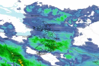 Seattle/Tacoma WA Radar
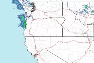 Northwest Radar